

38
6 Sediment Section from Shallow Pits
The foundation of the U-shaped Maitri station rests partly on the rock exposure and
partly on the glacial till deposits. During the construction of the station a number of
pits were made by the construction team. The depth of the pits varied from 45 cm to
about a meter depending upon depth of the bedrock or the permafrost zone, which
ever was reached earlier. Out of nearly 36 such pits, 05 pits of 0.75 × 0.75 × 100 cm
(Inset in Fig. 5) were selected for studying the vertical profile of the sediments.
Since all the pits are located within a rectangle of 55 m × 30 m, pits located at the
sides of the rectangle were selected to get the cross section along and across the
direction of extent of the deposit.
The top surface up to the depth of 25 cm was found to contain very coarse sand
with boulders. The boulders varied widely in composition and size and appear to
have been transported from long distances. The most common constituent of the
boulders are various varieties of gneisses (granite gneiss, augen gneiss, biotite
gneiss, alaskite etc.), followed by melanocratic rocks of dolerite, basalt and ultramafites. The coarse sand comprised quartz and plagioclase. This is followed by
about 8–12 cm thick horizon of coarse sand mixed with rock clasts. Mica and garnet
mark their presence in the sand but are not present in all the sections. The section
below, varying in depth from 23 to 43 cm, shows dominance of sand with minor silt
and pebble sized clasts, mostly of local provenance. The depth section from 35 to
58 cm comprised mostly sand + silt with cobble and pebble sized clasts of dark
Sand wt.
Silt wt.
1
2
3B
4
5
Clay wt.
Sand wt.
Silt wt.
Clay wt.
Sand wt.
Silt wt.
Clay wt.
Sand wt.
Silt wt.
Clay wt.
Sand wt.
Silt wt.
Clay wt.
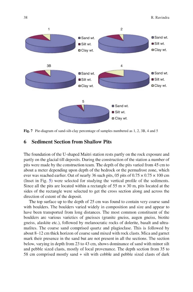
Fig. 7 Pie-diagram of sand-silt-clay percentage of samples numbered as 1, 2, 3B, 4 and 5
R. Ravindra
6 Sediment Section from Shallow Pits
The foundation of the U-shaped Maitri station rests partly on the rock exposure and
partly on the glacial till deposits. During the construction of the station a number of
pits were made by the construction team. The depth of the pits varied from 45 cm to
about a meter depending upon depth of the bedrock or the permafrost zone, which
ever was reached earlier. Out of nearly 36 such pits, 05 pits of 0.75 × 0.75 × 100 cm
(Inset in Fig. 5) were selected for studying the vertical profile of the sediments.
Since all the pits are located within a rectangle of 55 m × 30 m, pits located at the
sides of the rectangle were selected to get the cross section along and across the
direction of extent of the deposit.
The top surface up to the depth of 25 cm was found to contain very coarse sand
with boulders. The boulders varied widely in composition and size and appear to
have been transported from long distances. The most common constituent of the
boulders are various varieties of gneisses (granite gneiss, augen gneiss, biotite
gneiss, alaskite etc.), followed by melanocratic rocks of dolerite, basalt and ultramafites. The coarse sand comprised quartz and plagioclase. This is followed by
about 8–12 cm thick horizon of coarse sand mixed with rock clasts. Mica and garnet
mark their presence in the sand but are not present in all the sections. The section
below, varying in depth from 23 to 43 cm, shows dominance of sand with minor silt
and pebble sized clasts, mostly of local provenance. The depth section from 35 to
58 cm comprised mostly sand + silt with cobble and pebble sized clasts of dark
Sand wt.
Silt wt.
1
2
3B
4
5
Clay wt.
Sand wt.
Silt wt.
Clay wt.
Sand wt.
Silt wt.
Clay wt.
Sand wt.
Silt wt.
Clay wt.
Sand wt.
Silt wt.
Clay wt.
Fig. 7 Pie-diagram of sand-silt-clay percentage of samples numbered as 1, 2, 3B, 4 and 5
R. Ravindra