

190
phy of the deposits was ascertained and vertical lithologs were prepared depicting
distinct lithounits. The lithofacies were broadly grouped into fluvial gravel/sand,
floodplain silt-mud and landslide/alluvial fan debris, which are further divided into
sub-facies on the basis of colour, stratification, bedding geometry and sediment
organization (Table 1). The present day river profile is prepared on 3 arc (c.90 m)
Shuttle Radar Topographic Mission (SRTM) digital elevation model (DEMs) using
Global Mapper software and strands of landform surfaces, there continuity were
raised in profile from the present-day river bed through GPS based elevation. The
localized nickpoints were identified and probable causes were interpreted in field.
Areas where complete sections were not exposed, composite sections depicting
lithostratigraphy and vertical as well as lateral facies variation was established. The
distinct sediment aggradation phases were ascertained through sedimentological
attributes and chronostratigraphy of deposits supplemented by optically stimulated
luminescence (OSL) dating at TL/OSL Laboratory, Geological Survey of India,
Faridabad. Samples from appropriate sand lenses from sections exposed at basal
and top part of terrace and fan deposits for OSL chronology were collected in metallic pipes. Sandy fractions from the middle part of the pipe were processed in subdued red light for the removal of carbonate and organic matter using 1 N HCl and
30% H 2 O 2 , respectively. The 90–150 micron size grains were sieved from which
quartz grains were extracted by density separation using sodium polytungstate solution (Sp gr. 2.58). The grains were etched for 80 min in hydrofluoric acid (HF) to
remove the outer 20 micron layer which may have been affected by alpha radiation.
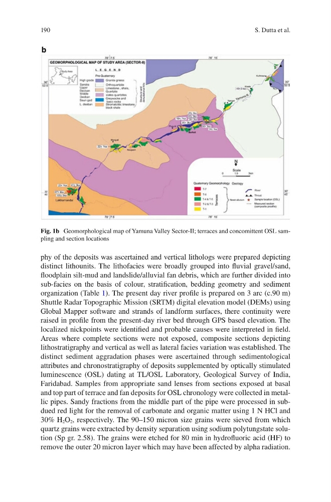
Fig. 1b Geomorphological map of Yamuna Valley Sector-II; terraces and concomittent OSL sampling and section locations
S. Dutta et al.
phy of the deposits was ascertained and vertical lithologs were prepared depicting
distinct lithounits. The lithofacies were broadly grouped into fluvial gravel/sand,
floodplain silt-mud and landslide/alluvial fan debris, which are further divided into
sub-facies on the basis of colour, stratification, bedding geometry and sediment
organization (Table 1). The present day river profile is prepared on 3 arc (c.90 m)
Shuttle Radar Topographic Mission (SRTM) digital elevation model (DEMs) using
Global Mapper software and strands of landform surfaces, there continuity were
raised in profile from the present-day river bed through GPS based elevation. The
localized nickpoints were identified and probable causes were interpreted in field.
Areas where complete sections were not exposed, composite sections depicting
lithostratigraphy and vertical as well as lateral facies variation was established. The
distinct sediment aggradation phases were ascertained through sedimentological
attributes and chronostratigraphy of deposits supplemented by optically stimulated
luminescence (OSL) dating at TL/OSL Laboratory, Geological Survey of India,
Faridabad. Samples from appropriate sand lenses from sections exposed at basal
and top part of terrace and fan deposits for OSL chronology were collected in metallic pipes. Sandy fractions from the middle part of the pipe were processed in subdued red light for the removal of carbonate and organic matter using 1 N HCl and
30% H 2 O 2 , respectively. The 90–150 micron size grains were sieved from which
quartz grains were extracted by density separation using sodium polytungstate solution (Sp gr. 2.58). The grains were etched for 80 min in hydrofluoric acid (HF) to
remove the outer 20 micron layer which may have been affected by alpha radiation.
Fig. 1b Geomorphological map of Yamuna Valley Sector-II; terraces and concomittent OSL sampling and section locations
S. Dutta et al.