

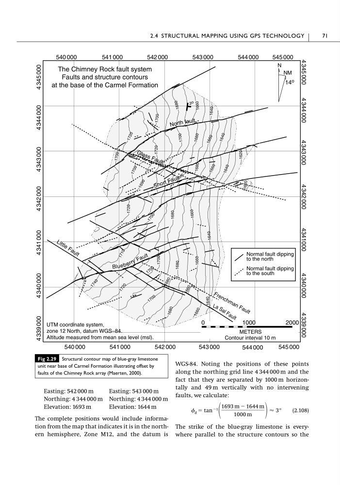
Easting: 542 000 m
Easting: 543 000 m
Northing: 4 344 000 m Northing: 4 344 000 m
Elevation: 1693 m
Elevation: 1644 m
The complete positions would include information from the map that indicates it is in the northern hemisphere, Zone M12, and the datum is
WGS-84. Noting the positions of these points
along the northing grid line 4 344 000 m and the
fact that they are separated by 1000 m horizontally and 49 m vertically with no intervening
faults, we calculate:
(2.108)
The strike of the blue-gray limestone is everywhere parallel to the structure contours so the
d ϭ tan Ϫ1
1693 m Ϫ 1644 m
1000 m
Ϸ 3°
2.4 STRUCTURAL MAPPING USING GPS TECHNOLOGY
71
Fig 2.29 Structural contour map of blue-gray limestone
unit near base of Carmel Formation illustrating offset by
faults of the Chimney Rock array (Maerten, 2000).
1640
1 6 4 0 1 6 4 0
1660
1680
1680
166
0
1 7 1 0
1700
1 7 0 0
1 6 8 0
1 6 6 0
1 7 2 0
1 7 4 0
1720
1 7 0 0
1 7 0 0
1 6 9 0
1 6 6 0
1 6 6 0
168 0
1 6 6 0
16 80
170
0
1720
16
80
170 0
166
0
1 7 2 0
1640
17 00
162 0
1620
1640
1 6 8 0
1 7 0 0
1 6 6 0
3 o
540 000
541 000
542 000
543 000
544 000
545 000
540 000
541 000
542 000
543 000
544 000
545 000
4 345 000
4 344 000
4 343 000
4 342 000
4341000
4 340 000
4 339 000
4 345 000
4 344 000
4 343 000
4 342 000
4 341 000
4 340 000
4 339 000
N
NM
14 o
Contour interval 10 m
METERS
0
1000
2000
The Chimney Rock fault system
Faults and structure contours
at the base of the Carmel Formation
UTM coordinate system,
zone 12 North, datum WGS–84.
Altitude measured from mean sea level (msl).
Normal fault dipping
to the north
Normal fault dipping
to the south
Blu ue b e e r r r r y y F a u lt
L a S a l F a u lt
L it t le F a u l t
S h o rt F a u lt
N or th fa ult
G la s s F a u lt
F r e n c h m a n F a u lt
Easting: 543 000 m
Northing: 4 344 000 m Northing: 4 344 000 m
Elevation: 1693 m
Elevation: 1644 m
The complete positions would include information from the map that indicates it is in the northern hemisphere, Zone M12, and the datum is
WGS-84. Noting the positions of these points
along the northing grid line 4 344 000 m and the
fact that they are separated by 1000 m horizontally and 49 m vertically with no intervening
faults, we calculate:
(2.108)
The strike of the blue-gray limestone is everywhere parallel to the structure contours so the
d ϭ tan Ϫ1
1693 m Ϫ 1644 m
1000 m
Ϸ 3°
2.4 STRUCTURAL MAPPING USING GPS TECHNOLOGY
71
Fig 2.29 Structural contour map of blue-gray limestone
unit near base of Carmel Formation illustrating offset by
faults of the Chimney Rock array (Maerten, 2000).
1640
1 6 4 0 1 6 4 0
1660
1680
1680
166
0
1 7 1 0
1700
1 7 0 0
1 6 8 0
1 6 6 0
1 7 2 0
1 7 4 0
1720
1 7 0 0
1 7 0 0
1 6 9 0
1 6 6 0
1 6 6 0
168 0
1 6 6 0
16 80
170
0
1720
16
80
170 0
166
0
1 7 2 0
1640
17 00
162 0
1620
1640
1 6 8 0
1 7 0 0
1 6 6 0
3 o
540 000
541 000
542 000
543 000
544 000
545 000
540 000
541 000
542 000
543 000
544 000
545 000
4 345 000
4 344 000
4 343 000
4 342 000
4341000
4 340 000
4 339 000
4 345 000
4 344 000
4 343 000
4 342 000
4 341 000
4 340 000
4 339 000
N
NM
14 o
Contour interval 10 m
METERS
0
1000
2000
The Chimney Rock fault system
Faults and structure contours
at the base of the Carmel Formation
UTM coordinate system,
zone 12 North, datum WGS–84.
Altitude measured from mean sea level (msl).
Normal fault dipping
to the north
Normal fault dipping
to the south
Blu ue b e e r r r r y y F a u lt
L a S a l F a u lt
L it t le F a u l t
S h o rt F a u lt
N or th fa ult
G la s s F a u lt
F r e n c h m a n F a u lt