

The Cartesian coordinates defined in the first line
of (2.29) are the scalar components of the position
vector. These scalar components carry the units of
length (meters) as do the radius, r, and axial
length, z. The angle, , is measured in radians
which may be thought of as the ratio of arc length
to radial length, s/r.
For modeling purposes it is helpful to reduce
the number of coordinates from three to two by
idealizing the structure as one that is perfectly
cylindrical. For the volcanic neck at Ship Rock
(Fig. 2.10c), we would say that it has a similar
geometry for any horizontal cross section within
several tens of meters of the current outcrop, so
we can ignore spatial variations in geometry,
material properties, and boundary conditions
with the axial coordinate z. Then we focus on the
two-dimensional polar coordinates (r, ) and define
the problem in terms of these two coordinates
(Fig. 2.10d). Radial lines of constant and circles
of constant r form an orthogonal network centered on the origin. The contact between the
minette of the neck and the Mancos Shale is
defined as a particular circle, r ϭ Rϭ15 m, with a
radius that best approximates that of the neck.
The alternative would be to define the contact in
terms of the Cartesian coordinates as the circle (x
2
ϩ y
2 )
1/2 ϭ R, but this is mathematically more cumbersome.
Similarly, the boundary (BC) and initial (IC)
conditions for models of the volcanic neck are
simplified using polar rather than Cartesian coordinates. For example consider a model for the conductive heat flow from the hot magma into the
cold host rock. The cylindrical geometry of the volcanic neck dictates a temperature field that varies
spatially only in the radial coordinate direction,
thereby reducing the problem to one spatial
dimension. Because the governing equation for
heat conduction is written with temperature as
the dependent variable, the initial conditions typically constrain the temperature field at some
specified time and the boundary conditions constrain the temperature field at specified locations
on the surface(s) of the body. Here we consider
initial conditions at the time t ϭ 0, such that the
temperature is uniform, T m , throughout the neck
and zero throughout the host rock. Then let the
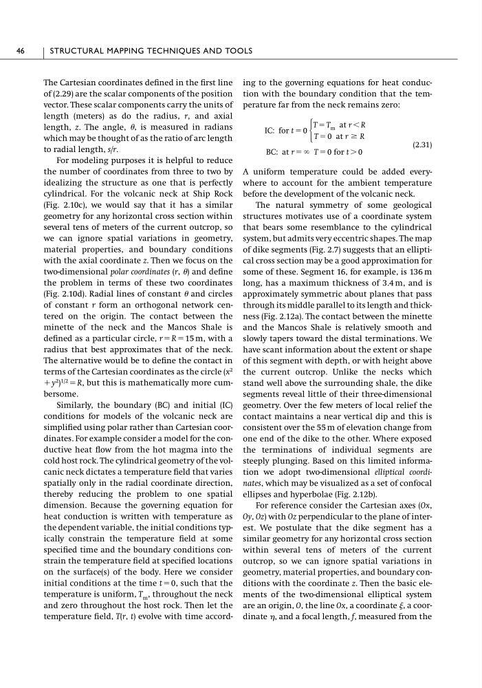
temperature field, T(r, t) evolve with time according to the governing equations for heat conduction with the boundary condition that the temperature far from the neck remains zero:
(2.31)
A uniform temperature could be added everywhere to account for the ambient temperature
before the development of the volcanic neck.
The natural symmetry of some geological
structures motivates use of a coordinate system
that bears some resemblance to the cylindrical
system, but admits very eccentric shapes. The map
of dike segments (Fig. 2.7) suggests that an elliptical cross section may be a good approximation for
some of these. Segment 16, for example, is 136 m
long, has a maximum thickness of 3.4 m, and is
approximately symmetric about planes that pass
through its middle parallel to its length and thickness (Fig. 2.12a). The contact between the minette
and the Mancos Shale is relatively smooth and
slowly tapers toward the distal terminations. We
have scant information about the extent or shape
of this segment with depth, or with height above
the current outcrop. Unlike the necks which
stand well above the surrounding shale, the dike
segments reveal little of their three-dimensional
geometry. Over the few meters of local relief the
contact maintains a near vertical dip and this is
consistent over the 55 m of elevation change from
one end of the dike to the other. Where exposed
the terminations of individual segments are
steeply plunging. Based on this limited information we adopt two-dimensional elliptical coordinates, which may be visualized as a set of confocal
ellipses and hyperbolae (Fig. 2.12b).
For reference consider the Cartesian axes (Ox,
Oy, Oz) with Oz perpendicular to the plane of interest. We postulate that the dike segment has a
similar geometry for any horizontal cross section
within several tens of meters of the current
outcrop, so we can ignore spatial variations in
geometry, material properties, and boundary conditions with the coordinate z. Then the basic elements of the two-dimensional elliptical system
are an origin, O, the line Ox, a coordinate , a coordinate , and a focal length, f, measured from the
BC: at r ϭ ϱ T ϭ 0 for t Ͼ 0
IC: for t ϭ 0
Ά
T ϭ T m at r Ͻ R
T ϭ 0 at r Ն R
46
STRUCTURAL MAPPING TECHNIQUES AND TOOLS
of (2.29) are the scalar components of the position
vector. These scalar components carry the units of
length (meters) as do the radius, r, and axial
length, z. The angle, , is measured in radians
which may be thought of as the ratio of arc length
to radial length, s/r.
For modeling purposes it is helpful to reduce
the number of coordinates from three to two by
idealizing the structure as one that is perfectly
cylindrical. For the volcanic neck at Ship Rock
(Fig. 2.10c), we would say that it has a similar
geometry for any horizontal cross section within
several tens of meters of the current outcrop, so
we can ignore spatial variations in geometry,
material properties, and boundary conditions
with the axial coordinate z. Then we focus on the
two-dimensional polar coordinates (r, ) and define
the problem in terms of these two coordinates
(Fig. 2.10d). Radial lines of constant and circles
of constant r form an orthogonal network centered on the origin. The contact between the
minette of the neck and the Mancos Shale is
defined as a particular circle, r ϭ Rϭ15 m, with a
radius that best approximates that of the neck.
The alternative would be to define the contact in
terms of the Cartesian coordinates as the circle (x
2
ϩ y
2 )
1/2 ϭ R, but this is mathematically more cumbersome.
Similarly, the boundary (BC) and initial (IC)
conditions for models of the volcanic neck are
simplified using polar rather than Cartesian coordinates. For example consider a model for the conductive heat flow from the hot magma into the
cold host rock. The cylindrical geometry of the volcanic neck dictates a temperature field that varies
spatially only in the radial coordinate direction,
thereby reducing the problem to one spatial
dimension. Because the governing equation for
heat conduction is written with temperature as
the dependent variable, the initial conditions typically constrain the temperature field at some
specified time and the boundary conditions constrain the temperature field at specified locations
on the surface(s) of the body. Here we consider
initial conditions at the time t ϭ 0, such that the
temperature is uniform, T m , throughout the neck
and zero throughout the host rock. Then let the
temperature field, T(r, t) evolve with time according to the governing equations for heat conduction with the boundary condition that the temperature far from the neck remains zero:
(2.31)
A uniform temperature could be added everywhere to account for the ambient temperature
before the development of the volcanic neck.
The natural symmetry of some geological
structures motivates use of a coordinate system
that bears some resemblance to the cylindrical
system, but admits very eccentric shapes. The map
of dike segments (Fig. 2.7) suggests that an elliptical cross section may be a good approximation for
some of these. Segment 16, for example, is 136 m
long, has a maximum thickness of 3.4 m, and is
approximately symmetric about planes that pass
through its middle parallel to its length and thickness (Fig. 2.12a). The contact between the minette
and the Mancos Shale is relatively smooth and
slowly tapers toward the distal terminations. We
have scant information about the extent or shape
of this segment with depth, or with height above
the current outcrop. Unlike the necks which
stand well above the surrounding shale, the dike
segments reveal little of their three-dimensional
geometry. Over the few meters of local relief the
contact maintains a near vertical dip and this is
consistent over the 55 m of elevation change from
one end of the dike to the other. Where exposed
the terminations of individual segments are
steeply plunging. Based on this limited information we adopt two-dimensional elliptical coordinates, which may be visualized as a set of confocal
ellipses and hyperbolae (Fig. 2.12b).
For reference consider the Cartesian axes (Ox,
Oy, Oz) with Oz perpendicular to the plane of interest. We postulate that the dike segment has a
similar geometry for any horizontal cross section
within several tens of meters of the current
outcrop, so we can ignore spatial variations in
geometry, material properties, and boundary conditions with the coordinate z. Then the basic elements of the two-dimensional elliptical system
are an origin, O, the line Ox, a coordinate , a coordinate , and a focal length, f, measured from the
BC: at r ϭ ϱ T ϭ 0 for t Ͼ 0
IC: for t ϭ 0
Ά
T ϭ T m at r Ͻ R
T ϭ 0 at r Ն R
46
STRUCTURAL MAPPING TECHNIQUES AND TOOLS