

igneous core at Mt. Hillers and the vertical dikes at
Mt. Holmes. No one would mistakenly claim that
these sketches are photographs because the simple
lines and patterns are mere representations. On
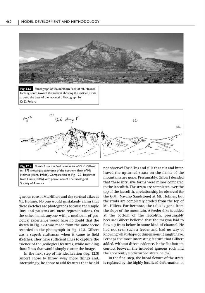
the other hand, anyone with a modicum of geological experience would have no doubt that the
sketch in Fig. 12.4 was made from the same scene
recorded in the photograph in Fig. 12.3. Gilbert
was a superb craftsman when it came to field
sketches. They have sufficient lines to capture the
essence of the geological features, while avoiding
those lines that would simply clutter the image.
In the next step of his idealization (Fig. 12.5)
Gilbert chose to throw away more things and,
interestingly, he chose to add features that he did
not observe! The dikes and sills that cut and interleaved the upturned strata on the flanks of the
mountains are gone. Presumably, Gilbert decided
that these intrusive forms were minor compared
to the laccolith. The strata are completed over the
top of the laccolith, a relationship he observed for
the G.M. (Navaho Sandstone) at Mt. Holmes, but
the strata are completely eroded from the top of
Mt. Hillers. Furthermore, the talus is gone from
the slope of the mountain. A feeder dike is added
at the bottom of the laccolith, presumably
because Gilbert believed that the magma had to
flow up from below in some kind of channel. He
had not seen such a feeder and had no way of
knowing what shape or dimensions it might have.
Perhaps the most interesting feature that Gilbert
added, without direct evidence, is the flat bottom
contact between the intruded igneous rock and
the apparently undisturbed strata below.
In the final step, the broad flexure of the strata
is replaced by the highly localized deformation of
460
MODEL DEVELOPMENT AND METHODOLOGY
Fig 12.3 Photograph of the northern flank of Mt. Holmes
looking south toward the summit showing the inclined strata
around the base of the mountain. Photograph by
D. D. Pollard
Fig 12.4 Sketch from the field notebooks of G. K. Gilbert
in 1875 showing a panorama of the northern flank of Mt.
Holmes (Hunt, 1988a). Compare this to Fig. 12.3. Reprinted
from Hunt (1988a) with permission of The Geological
Society of America.
Mt. Holmes. No one would mistakenly claim that
these sketches are photographs because the simple
lines and patterns are mere representations. On
the other hand, anyone with a modicum of geological experience would have no doubt that the
sketch in Fig. 12.4 was made from the same scene
recorded in the photograph in Fig. 12.3. Gilbert
was a superb craftsman when it came to field
sketches. They have sufficient lines to capture the
essence of the geological features, while avoiding
those lines that would simply clutter the image.
In the next step of his idealization (Fig. 12.5)
Gilbert chose to throw away more things and,
interestingly, he chose to add features that he did
not observe! The dikes and sills that cut and interleaved the upturned strata on the flanks of the
mountains are gone. Presumably, Gilbert decided
that these intrusive forms were minor compared
to the laccolith. The strata are completed over the
top of the laccolith, a relationship he observed for
the G.M. (Navaho Sandstone) at Mt. Holmes, but
the strata are completely eroded from the top of
Mt. Hillers. Furthermore, the talus is gone from
the slope of the mountain. A feeder dike is added
at the bottom of the laccolith, presumably
because Gilbert believed that the magma had to
flow up from below in some kind of channel. He
had not seen such a feeder and had no way of
knowing what shape or dimensions it might have.
Perhaps the most interesting feature that Gilbert
added, without direct evidence, is the flat bottom
contact between the intruded igneous rock and
the apparently undisturbed strata below.
In the final step, the broad flexure of the strata
is replaced by the highly localized deformation of
460
MODEL DEVELOPMENT AND METHODOLOGY
Fig 12.3 Photograph of the northern flank of Mt. Holmes
looking south toward the summit showing the inclined strata
around the base of the mountain. Photograph by
D. D. Pollard
Fig 12.4 Sketch from the field notebooks of G. K. Gilbert
in 1875 showing a panorama of the northern flank of Mt.
Holmes (Hunt, 1988a). Compare this to Fig. 12.3. Reprinted
from Hunt (1988a) with permission of The Geological
Society of America.