

12.2, 12.4) may be used to reproduce the scene for
others. Of course what one sees directly in the
field and then records on a photograph, sketch, or
map should be recognizably similar, but many features of the scene are lost, while others are captured in these procedures. The act of recording
the scene is a form of idealization. The photograph loses much of the three-dimensional view
provided by one’s eyes and may lose much of the
color information as well as features hidden in
shadows. Typically, sketches and maps record very
little of the totality of a given scene. Yet, with a
few lines and a bit of shading a skillful recorder
such as Gilbert can transform the visible scene
(Fig. 12.3) into a sketch (Fig. 12.4) that includes
most of the geologically salient features.
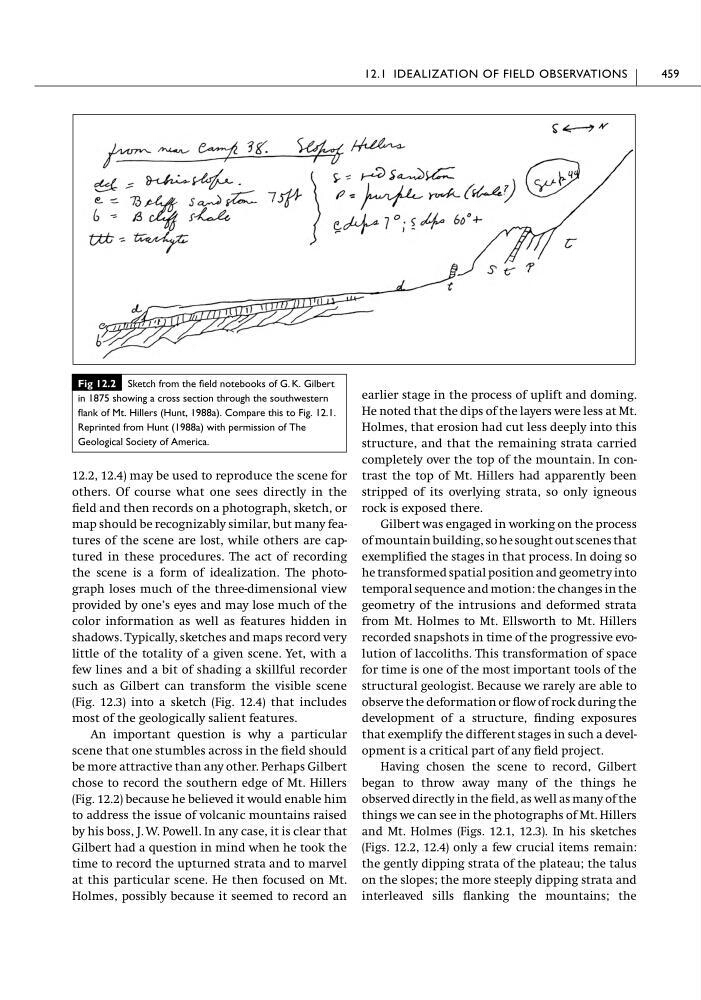
An important question is why a particular
scene that one stumbles across in the field should
be more attractive than any other. Perhaps Gilbert
chose to record the southern edge of Mt. Hillers
(Fig. 12.2) because he believed it would enable him
to address the issue of volcanic mountains raised
by his boss, J. W. Powell. In any case, it is clear that
Gilbert had a question in mind when he took the
time to record the upturned strata and to marvel
at this particular scene. He then focused on Mt.
Holmes, possibly because it seemed to record an
earlier stage in the process of uplift and doming.
He noted that the dips of the layers were less at Mt.
Holmes, that erosion had cut less deeply into this
structure, and that the remaining strata carried
completely over the top of the mountain. In contrast the top of Mt. Hillers had apparently been
stripped of its overlying strata, so only igneous
rock is exposed there.
Gilbert was engaged in working on the process
of mountain building, so he sought out scenes that
exemplified the stages in that process. In doing so
he transformed spatial position and geometry into
temporal sequence and motion: the changes in the
geometry of the intrusions and deformed strata
from Mt. Holmes to Mt. Ellsworth to Mt. Hillers
recorded snapshots in time of the progressive evolution of laccoliths. This transformation of space
for time is one of the most important tools of the
structural geologist. Because we rarely are able to
observe the deformation or flow of rock during the
development of a structure, finding exposures
that exemplify the different stages in such a development is a critical part of any field project.
Having chosen the scene to record, Gilbert
began to throw away many of the things he
observed directly in the field, as well as many of the
things we can see in the photographs of Mt. Hillers
and Mt. Holmes (Figs. 12.1, 12.3). In his sketches
(Figs. 12.2, 12.4) only a few crucial items remain:
the gently dipping strata of the plateau; the talus
on the slopes; the more steeply dipping strata and
interleaved sills flanking the mountains; the
12.1 IDEALIZATION OF FIELD OBSERVATIONS
459
Fig 12.2 Sketch from the field notebooks of G. K. Gilbert
in 1875 showing a cross section through the southwestern
flank of Mt. Hillers (Hunt, 1988a). Compare this to Fig. 12.1.
Reprinted from Hunt (1988a) with permission of The
Geological Society of America.
others. Of course what one sees directly in the
field and then records on a photograph, sketch, or
map should be recognizably similar, but many features of the scene are lost, while others are captured in these procedures. The act of recording
the scene is a form of idealization. The photograph loses much of the three-dimensional view
provided by one’s eyes and may lose much of the
color information as well as features hidden in
shadows. Typically, sketches and maps record very
little of the totality of a given scene. Yet, with a
few lines and a bit of shading a skillful recorder
such as Gilbert can transform the visible scene
(Fig. 12.3) into a sketch (Fig. 12.4) that includes
most of the geologically salient features.
An important question is why a particular
scene that one stumbles across in the field should
be more attractive than any other. Perhaps Gilbert
chose to record the southern edge of Mt. Hillers
(Fig. 12.2) because he believed it would enable him
to address the issue of volcanic mountains raised
by his boss, J. W. Powell. In any case, it is clear that
Gilbert had a question in mind when he took the
time to record the upturned strata and to marvel
at this particular scene. He then focused on Mt.
Holmes, possibly because it seemed to record an
earlier stage in the process of uplift and doming.
He noted that the dips of the layers were less at Mt.
Holmes, that erosion had cut less deeply into this
structure, and that the remaining strata carried
completely over the top of the mountain. In contrast the top of Mt. Hillers had apparently been
stripped of its overlying strata, so only igneous
rock is exposed there.
Gilbert was engaged in working on the process
of mountain building, so he sought out scenes that
exemplified the stages in that process. In doing so
he transformed spatial position and geometry into
temporal sequence and motion: the changes in the
geometry of the intrusions and deformed strata
from Mt. Holmes to Mt. Ellsworth to Mt. Hillers
recorded snapshots in time of the progressive evolution of laccoliths. This transformation of space
for time is one of the most important tools of the
structural geologist. Because we rarely are able to
observe the deformation or flow of rock during the
development of a structure, finding exposures
that exemplify the different stages in such a development is a critical part of any field project.
Having chosen the scene to record, Gilbert
began to throw away many of the things he
observed directly in the field, as well as many of the
things we can see in the photographs of Mt. Hillers
and Mt. Holmes (Figs. 12.1, 12.3). In his sketches
(Figs. 12.2, 12.4) only a few crucial items remain:
the gently dipping strata of the plateau; the talus
on the slopes; the more steeply dipping strata and
interleaved sills flanking the mountains; the
12.1 IDEALIZATION OF FIELD OBSERVATIONS
459
Fig 12.2 Sketch from the field notebooks of G. K. Gilbert
in 1875 showing a cross section through the southwestern
flank of Mt. Hillers (Hunt, 1988a). Compare this to Fig. 12.1.
Reprinted from Hunt (1988a) with permission of The
Geological Society of America.