

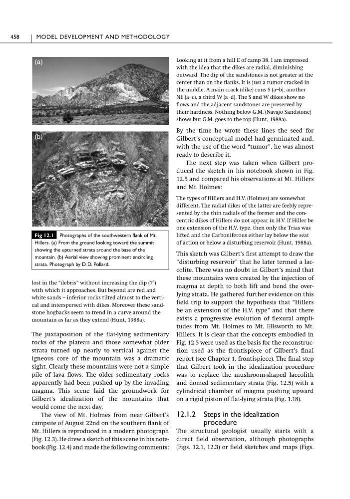
lost in the “debris” without increasing the dip (7Њ)
with which it approaches. But beyond are red and
white sands – inferior rocks tilted almost to the vertical and interspersed with dikes. Moreover these sandstone hogbacks seem to trend in a curve around the
mountain as far as they extend (Hunt, 1988a).
The juxtaposition of the flat-lying sedimentary
rocks of the plateau and those somewhat older
strata turned up nearly to vertical against the
igneous core of the mountain was a dramatic
sight. Clearly these mountains were not a simple
pile of lava flows. The older sedimentary rocks
apparently had been pushed up by the invading
magma. This scene laid the groundwork for
Gilbert’s idealization of the mountains that
would come the next day.
The view of Mt. Holmes from near Gilbert’s
campsite of August 22nd on the southern flank of
Mt. Hillers is reproduced in a modern photograph
(Fig. 12.3). He drew a sketch of this scene in his notebook (Fig. 12.4) and made the following comments:
Looking at it from a hill E of camp 38, I am impressed
with the idea that the dikes are radial, diminishing
outward. The dip of the sandstones is not greater at the
center than on the flanks. It is just a tumor cracked in
the middle. A main crack (dike) runs S (a–b), another
NE (a–c), a third W (a–d). The S and W dikes show no
flows and the adjacent sandstones are preserved by
their hardness. Nothing below G.M. (Navajo Sandstone)
shows but G.M. goes to the top (Hunt, 1988a).
By the time he wrote these lines the seed for
Gilbert’s conceptual model had germinated and,
with the use of the word “tumor”, he was almost
ready to describe it.
The next step was taken when Gilbert produced the sketch in his notebook shown in Fig.
12.5 and compared his observations at Mt. Hillers
and Mt. Holmes:
The types of Hillers and H.V. (Holmes) are somewhat
different. The radial dikes of the latter are feebly represented by the thin radials of the former and the concentric dikes of Hillers do not appear in H.V. If Hiller be
one extension of the H.V. type, then only the Trias was
lifted and the Carboniferous either lay below the seat
of action or below a disturbing reservoir (Hunt, 1988a).
This sketch was Gilbert’s first attempt to draw the
“disturbing reservoir” that he later termed a laccolite. There was no doubt in Gilbert’s mind that
these mountains were created by the injection of
magma at depth to both lift and bend the overlying strata. He gathered further evidence on this
field trip to support the hypothesis that “Hillers
be an extension of the H.V. type” and that there
exists a progressive evolution of flexural amplitudes from Mt. Holmes to Mt. Ellsworth to Mt.
Hillers. It is clear that the concepts embodied in
Fig. 12.5 were used as the basis for the reconstruction used as the frontispiece of Gilbert’s final
report (see Chapter 1, frontispiece). The final step
that Gilbert took in the idealization procedure
was to replace the mushroom-shaped laccolith
and domed sedimentary strata (Fig. 12.5) with a
cylindrical chamber of magma pushing upward
on a rigid piston of flat-lying strata (Fig. 1.18).
12.1.2 Steps in the idealization
procedure
The structural geologist usually starts with a
direct field observation, although photographs
(Figs. 12.1, 12.3) or field sketches and maps (Figs.
458
MODEL DEVELOPMENT AND METHODOLOGY
Fig 12.1 Photographs of the southwestern flank of Mt.
Hillers. (a) From the ground looking toward the summit
showing the upturned strata around the base of the
mountain. (b) Aerial view showing prominent encircling
strata. Photograph by D. D. Pollard.
(a)
(b)
with which it approaches. But beyond are red and
white sands – inferior rocks tilted almost to the vertical and interspersed with dikes. Moreover these sandstone hogbacks seem to trend in a curve around the
mountain as far as they extend (Hunt, 1988a).
The juxtaposition of the flat-lying sedimentary
rocks of the plateau and those somewhat older
strata turned up nearly to vertical against the
igneous core of the mountain was a dramatic
sight. Clearly these mountains were not a simple
pile of lava flows. The older sedimentary rocks
apparently had been pushed up by the invading
magma. This scene laid the groundwork for
Gilbert’s idealization of the mountains that
would come the next day.
The view of Mt. Holmes from near Gilbert’s
campsite of August 22nd on the southern flank of
Mt. Hillers is reproduced in a modern photograph
(Fig. 12.3). He drew a sketch of this scene in his notebook (Fig. 12.4) and made the following comments:
Looking at it from a hill E of camp 38, I am impressed
with the idea that the dikes are radial, diminishing
outward. The dip of the sandstones is not greater at the
center than on the flanks. It is just a tumor cracked in
the middle. A main crack (dike) runs S (a–b), another
NE (a–c), a third W (a–d). The S and W dikes show no
flows and the adjacent sandstones are preserved by
their hardness. Nothing below G.M. (Navajo Sandstone)
shows but G.M. goes to the top (Hunt, 1988a).
By the time he wrote these lines the seed for
Gilbert’s conceptual model had germinated and,
with the use of the word “tumor”, he was almost
ready to describe it.
The next step was taken when Gilbert produced the sketch in his notebook shown in Fig.
12.5 and compared his observations at Mt. Hillers
and Mt. Holmes:
The types of Hillers and H.V. (Holmes) are somewhat
different. The radial dikes of the latter are feebly represented by the thin radials of the former and the concentric dikes of Hillers do not appear in H.V. If Hiller be
one extension of the H.V. type, then only the Trias was
lifted and the Carboniferous either lay below the seat
of action or below a disturbing reservoir (Hunt, 1988a).
This sketch was Gilbert’s first attempt to draw the
“disturbing reservoir” that he later termed a laccolite. There was no doubt in Gilbert’s mind that
these mountains were created by the injection of
magma at depth to both lift and bend the overlying strata. He gathered further evidence on this
field trip to support the hypothesis that “Hillers
be an extension of the H.V. type” and that there
exists a progressive evolution of flexural amplitudes from Mt. Holmes to Mt. Ellsworth to Mt.
Hillers. It is clear that the concepts embodied in
Fig. 12.5 were used as the basis for the reconstruction used as the frontispiece of Gilbert’s final
report (see Chapter 1, frontispiece). The final step
that Gilbert took in the idealization procedure
was to replace the mushroom-shaped laccolith
and domed sedimentary strata (Fig. 12.5) with a
cylindrical chamber of magma pushing upward
on a rigid piston of flat-lying strata (Fig. 1.18).
12.1.2 Steps in the idealization
procedure
The structural geologist usually starts with a
direct field observation, although photographs
(Figs. 12.1, 12.3) or field sketches and maps (Figs.
458
MODEL DEVELOPMENT AND METHODOLOGY
Fig 12.1 Photographs of the southwestern flank of Mt.
Hillers. (a) From the ground looking toward the summit
showing the upturned strata around the base of the
mountain. (b) Aerial view showing prominent encircling
strata. Photograph by D. D. Pollard.
(a)
(b)