

on the Greenwich meridian ⌬ ϭ . All forms of
this projection are limited in that an entire hemisphere cannot be projected: the boundary of the
hemisphere would plot at an infinite distance
from the origin.
One of the more common projections in use
today is the Transverse Mercator (TM) projection in
which a spherical or ellipsoidal datum is projected
onto a right circular cylinder. The mathematical
procedure used to accomplish the projection is
called conformal mapping (Hofmann-Wellenhof et
al., 1997, p. 287). As the name implies this transformation and others in this class preserve the
angular relations of curves on the datum. The TM
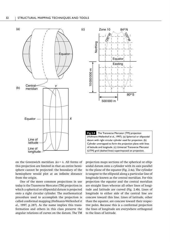
projection maps sections of the spherical or ellipsoidal datum onto a cylinder with its axis parallel
to the plane of the equator (Fig. 2.4a). The cylinder
is tangent to the ellipsoid along a particular line of
longitude known as the central meridian. For this
projection the equator and the central meridian
are straight lines whereas all other lines of longitude and latitude are curved (Fig. 2.4b). Lines of
longitude to either side of the central line are
concave toward this line. Lines of latitude, other
than the equator, are concave toward their respective poles. Because this is a conformal projection
the lines of longitude are everywhere orthogonal
to the lines of latitude.
32
STRUCTURAL MAPPING TECHNIQUES AND TOOLS
Zone 10
Northing
500 000 m
Easting
Equator
Line of
latitude
(a)
(b)
(c)
Y
X
Line of
longitude
Central
meridian
Equator Equator
Equator
84 o N
1 2 6 o
W
1 2 0
o
W
10 000 000 m
80 o S
Fig 2.4 The Transverse Mercator (TM) projection
(Hofmann-Wellenhof et al., 1997). (a) Spherical or ellipsoidal
datum with right circular cylinder used for projection. (b)
Cylinder unwrapped to form the projection plane with lines
of latitude and longitude. (c) Universal Transverse Mercator
(UTM) grid (dashed lines) superimposed on projection.
this projection are limited in that an entire hemisphere cannot be projected: the boundary of the
hemisphere would plot at an infinite distance
from the origin.
One of the more common projections in use
today is the Transverse Mercator (TM) projection in
which a spherical or ellipsoidal datum is projected
onto a right circular cylinder. The mathematical
procedure used to accomplish the projection is
called conformal mapping (Hofmann-Wellenhof et
al., 1997, p. 287). As the name implies this transformation and others in this class preserve the
angular relations of curves on the datum. The TM
projection maps sections of the spherical or ellipsoidal datum onto a cylinder with its axis parallel
to the plane of the equator (Fig. 2.4a). The cylinder
is tangent to the ellipsoid along a particular line of
longitude known as the central meridian. For this
projection the equator and the central meridian
are straight lines whereas all other lines of longitude and latitude are curved (Fig. 2.4b). Lines of
longitude to either side of the central line are
concave toward this line. Lines of latitude, other
than the equator, are concave toward their respective poles. Because this is a conformal projection
the lines of longitude are everywhere orthogonal
to the lines of latitude.
32
STRUCTURAL MAPPING TECHNIQUES AND TOOLS
Zone 10
Northing
500 000 m
Easting
Equator
Line of
latitude
(a)
(b)
(c)
Y
X
Line of
longitude
Central
meridian
Equator Equator
Equator
84 o N
1 2 6 o
W
1 2 0
o
W
10 000 000 m
80 o S
Fig 2.4 The Transverse Mercator (TM) projection
(Hofmann-Wellenhof et al., 1997). (a) Spherical or ellipsoidal
datum with right circular cylinder used for projection. (b)
Cylinder unwrapped to form the projection plane with lines
of latitude and longitude. (c) Universal Transverse Mercator
(UTM) grid (dashed lines) superimposed on projection.