

through the center of the sphere) and therefore
the shortest paths from this point to any other on
the sphere.
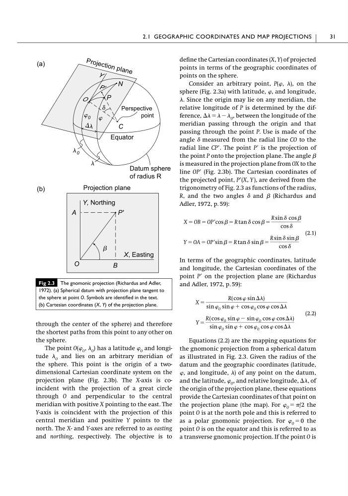
The point O(� O , � O ) has a latitude � O and longitude � O and lies on an arbitrary meridian of
the sphere. This point is the origin of a twodimensional Cartesian coordinate system on the
projection plane (Fig. 2.3b). The X-axis is coincident with the projection of a great circle
through O and perpendicular to the central
meridian with positive X pointing to the east. The
Y-axis is coincident with the projection of this
central meridian and positive Y points to the
north. The X- and Y-axes are referred to as easting
and northing, respectively. The objective is to
define the Cartesian coordinates (X, Y) of projected
points in terms of the geographic coordinates of
points on the sphere.
Consider an arbitrary point, P(�, �), on the
sphere (Fig. 2.3a) with latitude, �, and longitude,
�. Since the origin may lie on any meridian, the
relative longitude of P is determined by the difference, �� � � � � O , between the longitude of the
meridian passing through the origin and that
passing through the point P. Use is made of the
angle � measured from the radial line CO to the
radial line CP�. The point P� is the projection of
the point P onto the projection plane. The angle �
is measured in the projection plane from OX to the
line OP� (Fig. 2.3b). The Cartesian coordinates of
the projected point, P�(X, Y ), are derived from the
trigonometry of Fig. 2.3 as functions of the radius,
R, and the two angles � and � (Richardus and
Adler, 1972, p. 59):
(2.1)
In terms of the geographic coordinates, latitude
and longitude, the Cartesian coordinates of the
point P� on the projection plane are (Richardus
and Adler, 1972, p. 59):
(2.2)
Equations (2.2) are the mapping equations for
the gnomonic projection from a spherical datum
as illustrated in Fig. 2.3. Given the radius of the
datum and the geographic coordinates (latitude,
�, and longitude, �) of any point on the datum,
and the latitude, � O , and relative longitude, ��, of
the origin of the projection plane, these equations
provide the Cartesian coordinates of that point on
the projection plane (the map). For � O � �/2 the
point O is at the north pole and this is referred to
as a polar gnomonic projection. For � O � 0 the
point O is on the equator and this is referred to as
a transverse gnomonic projection. If the point O is
Y �
R( cos � O sin � � sin � O cos � cos ��)
sin � O sin � � cos � O cos � cos ��
X �
R( cos � sin ��)
sin � O sin � � cos � O cos � cos ��
Y � OA � OP�sin � � R tan � sin � �
R sin � sin �
cos �
X � OB � OP�cos � � R tan � cos � �
R sin � cos �
cos �
2.1 GEOGRAPHIC COORDINATES AND MAP PROJECTIONS
31
(a)
N
Equator
P
P '
C
␦
⌬
O
Y
O
X, Easting
Y, Northing
P'

Projection plane
(b)
A
B
P ro je c ti o n p la n e
Perspective
point
0
0
Datum sphere
of radius R
Fig 2.3 The gnomonic projection (Richardus and Adler,
1972). (a) Spherical datum with projection plane tangent to
the sphere at point O. Symbols are identified in the text.
(b) Cartesian coordinates (X, Y) of the projection plane.
the shortest paths from this point to any other on
the sphere.
The point O(� O , � O ) has a latitude � O and longitude � O and lies on an arbitrary meridian of
the sphere. This point is the origin of a twodimensional Cartesian coordinate system on the
projection plane (Fig. 2.3b). The X-axis is coincident with the projection of a great circle
through O and perpendicular to the central
meridian with positive X pointing to the east. The
Y-axis is coincident with the projection of this
central meridian and positive Y points to the
north. The X- and Y-axes are referred to as easting
and northing, respectively. The objective is to
define the Cartesian coordinates (X, Y) of projected
points in terms of the geographic coordinates of
points on the sphere.
Consider an arbitrary point, P(�, �), on the
sphere (Fig. 2.3a) with latitude, �, and longitude,
�. Since the origin may lie on any meridian, the
relative longitude of P is determined by the difference, �� � � � � O , between the longitude of the
meridian passing through the origin and that
passing through the point P. Use is made of the
angle � measured from the radial line CO to the
radial line CP�. The point P� is the projection of
the point P onto the projection plane. The angle �
is measured in the projection plane from OX to the
line OP� (Fig. 2.3b). The Cartesian coordinates of
the projected point, P�(X, Y ), are derived from the
trigonometry of Fig. 2.3 as functions of the radius,
R, and the two angles � and � (Richardus and
Adler, 1972, p. 59):
(2.1)
In terms of the geographic coordinates, latitude
and longitude, the Cartesian coordinates of the
point P� on the projection plane are (Richardus
and Adler, 1972, p. 59):
(2.2)
Equations (2.2) are the mapping equations for
the gnomonic projection from a spherical datum
as illustrated in Fig. 2.3. Given the radius of the
datum and the geographic coordinates (latitude,
�, and longitude, �) of any point on the datum,
and the latitude, � O , and relative longitude, ��, of
the origin of the projection plane, these equations
provide the Cartesian coordinates of that point on
the projection plane (the map). For � O � �/2 the
point O is at the north pole and this is referred to
as a polar gnomonic projection. For � O � 0 the
point O is on the equator and this is referred to as
a transverse gnomonic projection. If the point O is
Y �
R( cos � O sin � � sin � O cos � cos ��)
sin � O sin � � cos � O cos � cos ��
X �
R( cos � sin ��)
sin � O sin � � cos � O cos � cos ��
Y � OA � OP�sin � � R tan � sin � �
R sin � sin �
cos �
X � OB � OP�cos � � R tan � cos � �
R sin � cos �
cos �
2.1 GEOGRAPHIC COORDINATES AND MAP PROJECTIONS
31
(a)
N
Equator
P
P '
C
␦
⌬
O
Y
O
X, Easting
Y, Northing
P'

Projection plane
(b)
A
B
P ro je c ti o n p la n e
Perspective
point
0
0
Datum sphere
of radius R
Fig 2.3 The gnomonic projection (Richardus and Adler,
1972). (a) Spherical datum with projection plane tangent to
the sphere at point O. Symbols are identified in the text.
(b) Cartesian coordinates (X, Y) of the projection plane.