

Grove Karl Gilbert, to investigate the Wasatch
Plateau, just west of the Henry Mountains, and to
carry out a topographic and geologic survey of the
region. Gilbert’s career and his many contributions to geology are described in the book Grove
Karl Gilbert: A Great Engine of Research (Pyne, 1980).
Gilbert worked from horseback covering an area
from Salina, Utah, to the western edge of the
Henry Mountains from late June to mid August of
1875 (Gilbert, 1877). The chronicle of this trip is
clearly laid out in his field notebooks and these
have been reproduced and annotated by Charles
Hunt (Hunt, 1988a).
The frontispiece from Gilbert’s Report on the
Geology of the Henry Mountains, published in 1877, is
reproduced as an inset on the frontispiece for this
chapter. This drawing illustrates the form of the
displaced (and now eroded) sedimentary strata
forming the structural dome that is M. Ellsworth.
The base of this diagram is taken at modern sea
level and the strata are broadly divided into four
layers: the upper Paleozoic at the bottom, followed by the Triassic and Jurassic, then the
Cretaceous, and finally the Tertiary at the top. The
near half of the diagram displays the current
topography of Mt. Ellsworth and the remote half
shows the form of the strata in the structural
dome. In the preface to this report Gilbert comments as follows:
Two months would be far too short a period in which
to survey a thousand square miles in Pennsylvania or
Illinois, but among the Colorado Plateaus it proved
sufficient. A few comprehensive views from mountain
tops gave the general distribution of the formations,
and the remainder of the time was spent in the examination of the localities which best displayed the peculiar features of the structure. So thorough was the
display and so satisfactory the examination, that in
preparing my report I have felt less than ever before
the desire to revisit the field and prove my conclusions
by more extended observation (Gilbert, 1877, p. vii).
Those “peculiar features of the structure” revealed
the two major processes that shaped the Henry
Mountains, upward displacement of the strata and
the progress of erosion that carved the mountains
as we know them today. As structural geologists it
is the first of these processes that captures our
attention, while the geomorphologist would naturally focus on the second.
1.5.1 Conceptual and mechanical models
for laccolith formation
Although exposures in the three southern Henry
Mountains do not reveal the bottoms of the larger
masses of igneous rock or the conduits that fed
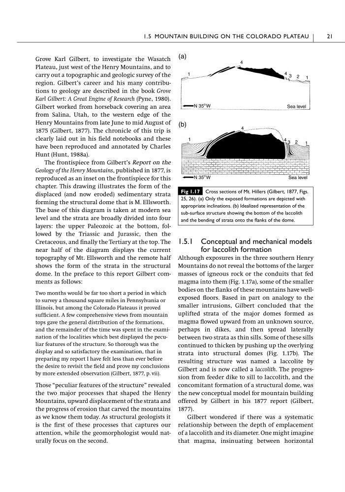
magma into them (Fig. 1.17a), some of the smaller
bodies on the flanks of these mountains have wellexposed floors. Based in part on analogy to the
smaller intrusions, Gilbert concluded that the
uplifted strata of the major domes formed as
magma flowed upward from an unknown source,
perhaps in dikes, and then spread laterally
between two strata as thin sills. Some of these sills
continued to thicken by pushing up the overlying
strata into structural domes (Fig. 1.17b). The
resulting structure was named a laccolite by
Gilbert and is now called a laccolith. The progression from feeder dike to sill to laccolith, and the
concomitant formation of a structural dome, was
the new conceptual model for mountain building
offered by Gilbert in his 1877 report (Gilbert,
1877).
Gilbert wondered if there was a systematic
relationship between the depth of emplacement
of a laccolith and its diameter. One might imagine
that magma, insinuating between horizontal
1.5 MOUNTAIN BUILDING ON THE COLORADO PLATEAU
21
1
4
4 3 2 1
N 35
o W
Sea level
Sea level
N 35
o W
1
4
4 3 2
1
(a)
(b)
Fig 1.17 Cross sections of Mt. Hillers (Gilbert, 1877, Figs.
25, 26). (a) Only the exposed formations are depicted with
appropriate inclinations. (b) Idealized representation of the
sub-surface structure showing the bottom of the laccolith
and the bending of strata onto the flanks of the dome.
Plateau, just west of the Henry Mountains, and to
carry out a topographic and geologic survey of the
region. Gilbert’s career and his many contributions to geology are described in the book Grove
Karl Gilbert: A Great Engine of Research (Pyne, 1980).
Gilbert worked from horseback covering an area
from Salina, Utah, to the western edge of the
Henry Mountains from late June to mid August of
1875 (Gilbert, 1877). The chronicle of this trip is
clearly laid out in his field notebooks and these
have been reproduced and annotated by Charles
Hunt (Hunt, 1988a).
The frontispiece from Gilbert’s Report on the
Geology of the Henry Mountains, published in 1877, is
reproduced as an inset on the frontispiece for this
chapter. This drawing illustrates the form of the
displaced (and now eroded) sedimentary strata
forming the structural dome that is M. Ellsworth.
The base of this diagram is taken at modern sea
level and the strata are broadly divided into four
layers: the upper Paleozoic at the bottom, followed by the Triassic and Jurassic, then the
Cretaceous, and finally the Tertiary at the top. The
near half of the diagram displays the current
topography of Mt. Ellsworth and the remote half
shows the form of the strata in the structural
dome. In the preface to this report Gilbert comments as follows:
Two months would be far too short a period in which
to survey a thousand square miles in Pennsylvania or
Illinois, but among the Colorado Plateaus it proved
sufficient. A few comprehensive views from mountain
tops gave the general distribution of the formations,
and the remainder of the time was spent in the examination of the localities which best displayed the peculiar features of the structure. So thorough was the
display and so satisfactory the examination, that in
preparing my report I have felt less than ever before
the desire to revisit the field and prove my conclusions
by more extended observation (Gilbert, 1877, p. vii).
Those “peculiar features of the structure” revealed
the two major processes that shaped the Henry
Mountains, upward displacement of the strata and
the progress of erosion that carved the mountains
as we know them today. As structural geologists it
is the first of these processes that captures our
attention, while the geomorphologist would naturally focus on the second.
1.5.1 Conceptual and mechanical models
for laccolith formation
Although exposures in the three southern Henry
Mountains do not reveal the bottoms of the larger
masses of igneous rock or the conduits that fed
magma into them (Fig. 1.17a), some of the smaller
bodies on the flanks of these mountains have wellexposed floors. Based in part on analogy to the
smaller intrusions, Gilbert concluded that the
uplifted strata of the major domes formed as
magma flowed upward from an unknown source,
perhaps in dikes, and then spread laterally
between two strata as thin sills. Some of these sills
continued to thicken by pushing up the overlying
strata into structural domes (Fig. 1.17b). The
resulting structure was named a laccolite by
Gilbert and is now called a laccolith. The progression from feeder dike to sill to laccolith, and the
concomitant formation of a structural dome, was
the new conceptual model for mountain building
offered by Gilbert in his 1877 report (Gilbert,
1877).
Gilbert wondered if there was a systematic
relationship between the depth of emplacement
of a laccolith and its diameter. One might imagine
that magma, insinuating between horizontal
1.5 MOUNTAIN BUILDING ON THE COLORADO PLATEAU
21
1
4
4 3 2 1
N 35
o W
Sea level
Sea level
N 35
o W
1
4
4 3 2
1
(a)
(b)
Fig 1.17 Cross sections of Mt. Hillers (Gilbert, 1877, Figs.
25, 26). (a) Only the exposed formations are depicted with
appropriate inclinations. (b) Idealized representation of the
sub-surface structure showing the bottom of the laccolith
and the bending of strata onto the flanks of the dome.