

1.5 Mountain building on the
Colorado Plateau
We are geologists because we love beautiful mineral
specimens or fine fossils or magnificent mountains
(Woodford, 1956).
Many structural geologists would argue that the
premier research topic in this discipline is mountain building. Mountain building produces many
of the most dramatic landscapes on our planet
and provides countless opportunities to escape
from urban settings into the wilderness for different forms of recreation. Mountains profoundly
affect local climates and provide challenges to
builders of roads and dams. Few can say that their
lives are not affected in some way by mountains.
The obvious question is: why are they there? No
single answer is credible and geologists have
identified several tectonic processes that lead to
mountain building. Here we describe one such
process because it is rather simple to understand
and because it informs us about an interesting
chapter in the development of structural geology
in the latter half of the nineteenth century.
Our story begins when John Wesley Powell
stopped briefly on one of his harrowing boat trips
down the Colorado River (1869–71) and climbed
up out of the deep canyon to look around. Across
the plateau country of southern Utah Powell saw
several mountain peaks, capped with massive
gray rock that clearly was not sedimentary. One of
the nearby peaks, later named Mt. Hillers, is
shown on the frontispiece for this chapter. Powell
gave the range a name, the Henry Mountains, in
honor of the distinguished physicist Joseph
Henry. In hindsight it is fitting that this range,
which would reveal to others one of the fundamental physical processes of mountain building,
should be named for a physicist.
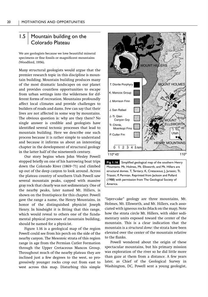
Figure 1.16 is a geological map of the region
Powell could see from his perch on the side of the
nearby canyon. The Mesozoic strata of this region
range in age from the Permian Cutler Formation
through the Upper Cretaceous Mancos Group.
Throughout much of the nearby plateau they are
inclined just a few degrees to the west, so progressively younger rocks crop out from east to
west across this map. Disturbing this simple
“layer-cake” geology are three mountains, Mt.
Holmes, Mt. Ellsworth, and Mt. Hillers, each associated with igneous rocks (black on the map). Note
how the strata circle Mt. Hillers, with older sedimentary units exposed toward the center of the
mountain. This is a clear indication that the
mountain is a structural dome: the strata have been
elevated over the center of the mountain relative
to the flanks.
Powell wondered about the origin of these
spectacular mountains, but his primary mission
was exploration of the river so he did little more
than gaze at them from a distance. A few years
later, as Chief of the Geological Survey in
Washington, DC, Powell sent a young geologist,
20
MOTIVATIONS AND OPPORTUNITIES
MOUNT HILLERS
MOUNT HOLMES
MOUNT
ELLSWORTH
37 o 45'
Utah
HENRY MOUNTAINS
5
4
3
2
1
0
110 o
110
o 45'
T. Diorite Porphyry
K. Mancos Group
J. Morrison Fmn
J. San Rafael
J.-Tr. Glen
Canyon Grp
Tr. Chinle,
Moenkopi Fms
P. Cutler Fm
km
Fig 1.16 Simplified geological map of the southern Henry
Mountains. Mt. Holmes, Mt. Ellsworth, and Mt. Hillers are
structural domes. T, Tertiary; K, Cretaceous; J, Jurassic; Tr,
Triassic; P, Permian. Reprinted from Jackson and Pollard
(1988) with permission from The Geological Society of
America.
Colorado Plateau
We are geologists because we love beautiful mineral
specimens or fine fossils or magnificent mountains
(Woodford, 1956).
Many structural geologists would argue that the
premier research topic in this discipline is mountain building. Mountain building produces many
of the most dramatic landscapes on our planet
and provides countless opportunities to escape
from urban settings into the wilderness for different forms of recreation. Mountains profoundly
affect local climates and provide challenges to
builders of roads and dams. Few can say that their
lives are not affected in some way by mountains.
The obvious question is: why are they there? No
single answer is credible and geologists have
identified several tectonic processes that lead to
mountain building. Here we describe one such
process because it is rather simple to understand
and because it informs us about an interesting
chapter in the development of structural geology
in the latter half of the nineteenth century.
Our story begins when John Wesley Powell
stopped briefly on one of his harrowing boat trips
down the Colorado River (1869–71) and climbed
up out of the deep canyon to look around. Across
the plateau country of southern Utah Powell saw
several mountain peaks, capped with massive
gray rock that clearly was not sedimentary. One of
the nearby peaks, later named Mt. Hillers, is
shown on the frontispiece for this chapter. Powell
gave the range a name, the Henry Mountains, in
honor of the distinguished physicist Joseph
Henry. In hindsight it is fitting that this range,
which would reveal to others one of the fundamental physical processes of mountain building,
should be named for a physicist.
Figure 1.16 is a geological map of the region
Powell could see from his perch on the side of the
nearby canyon. The Mesozoic strata of this region
range in age from the Permian Cutler Formation
through the Upper Cretaceous Mancos Group.
Throughout much of the nearby plateau they are
inclined just a few degrees to the west, so progressively younger rocks crop out from east to
west across this map. Disturbing this simple
“layer-cake” geology are three mountains, Mt.
Holmes, Mt. Ellsworth, and Mt. Hillers, each associated with igneous rocks (black on the map). Note
how the strata circle Mt. Hillers, with older sedimentary units exposed toward the center of the
mountain. This is a clear indication that the
mountain is a structural dome: the strata have been
elevated over the center of the mountain relative
to the flanks.
Powell wondered about the origin of these
spectacular mountains, but his primary mission
was exploration of the river so he did little more
than gaze at them from a distance. A few years
later, as Chief of the Geological Survey in
Washington, DC, Powell sent a young geologist,
20
MOTIVATIONS AND OPPORTUNITIES
MOUNT HILLERS
MOUNT HOLMES
MOUNT
ELLSWORTH
37 o 45'
Utah
HENRY MOUNTAINS
5
4
3
2
1
0
110 o
110
o 45'
T. Diorite Porphyry
K. Mancos Group
J. Morrison Fmn
J. San Rafael
J.-Tr. Glen
Canyon Grp
Tr. Chinle,
Moenkopi Fms
P. Cutler Fm
km
Fig 1.16 Simplified geological map of the southern Henry
Mountains. Mt. Holmes, Mt. Ellsworth, and Mt. Hillers are
structural domes. T, Tertiary; K, Cretaceous; J, Jurassic; Tr,
Triassic; P, Permian. Reprinted from Jackson and Pollard
(1988) with permission from The Geological Society of
America.