

not perturbed by the valley, so it remains compressive and increases in magnitude linearly with
depth below the horizontal surface. Contours of
the total circumferential stress are straight horizontal lines throughout the half-space including
the vicinity of the valley (Fig. 8.22c). The total circumferential stress at the valley bottom is:
(8.91)
In other words, the normal stress acting in the
horizontal direction is compressive, and scales in
magnitude with the average unit weight of the
surrounding rock mass and with the vertical distance from the valley rim to the valley floor.
Because the polar component of total shear stress
is zero, the stress trajectories are radial lines (least
compressive stress) and circumferential curves
(greatest compressive stress).
One of the more interesting structures associated with deeply incised canyons are so-called
valley anticlines (Potter and McGill, 1978). Potter
and McGill identify two types of valley anticlines.
The first type is characterized as broad upright
folds that follow major drainages and, although
the folding tends to die out upward, it may deflect
strata all the way to the valley rim, up to 600 m
above the valley floor. The second type is smaller,
sometimes with straighter limbs and tighter
hinges, and usually is confined to thin-bedded
strata on the valley floor. The spatial association of
landforms and structures often leads to an interpretation that the landform (drainage channel in
this case) was superimposed on the structure
because deformation related to the structure
made the rock more susceptible to erosion.
However, valley anticlines are interpreted in just
the opposite way: the fluvial valley predated the
anticline and the location of the fold was determined by the course of the river.
Superb outcrops of both types of valley anticlines are found in Canyonlands National Park,
southeastern Utah (Potter and McGill, 1978;
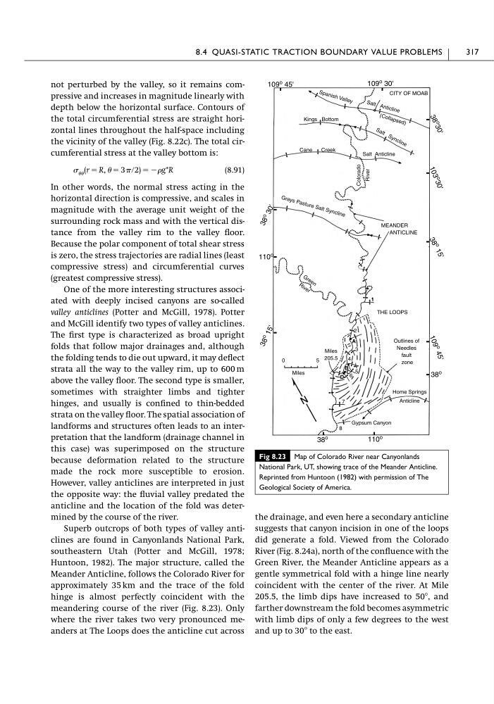
Huntoon, 1982). The major structure, called the
Meander Anticline, follows the Colorado River for
approximately 35 km and the trace of the fold
hinge is almost perfectly coincident with the
meandering course of the river (Fig. 8.23). Only
where the river takes two very pronounced meanders at The Loops does the anticline cut across
(r ϭ R, ϭ 3 ր2) ϭ Ϫg*R
the drainage, and even here a secondary anticline
suggests that canyon incision in one of the loops
did generate a fold. Viewed from the Colorado
River (Fig. 8.24a), north of the confluence with the
Green River, the Meander Anticline appears as a
gentle symmetrical fold with a hinge line nearly
coincident with the center of the river. At Mile
205.5, the limb dips have increased to 50Њ, and
farther downstream the fold becomes asymmetric
with limb dips of only a few degrees to the west
and up to 30Њ to the east.
8.4 QUASI-STATIC TRACTION BOUNDARY VALUE PROBLEMS
317
Fig 8.23 Map of Colorado River near Canyonlands
National Park, UT, showing trace of the Meander Anticline.
Reprinted from Huntoon (1982) with permission of The
Geological Society of America.
109
o 45'
109 o 30'
3 8
o
3 0 '
1 0 3
o
3 0 '
3 8
o
1 5 '
1 0 9
o
4 5 '
38 o
110
o
38 o
3 8 o
1 5 '
110
o
3 8 o
3 0 '
S pa ni sh Va lle y
Sa lt An tic lin e
CITY OF MOAB
(C ol la ps ed )
S a lt S y n c li n e
Cane
Creek
Colorado River
Kings Bottom
Salt Anticline
G ra ys Pa st ur e Sa lt Sy nc lin e
MEANDER
ANTICLINE
G r e e n
R iv e r
THE LOOPS
Outlines of
Needles
fault
zone
Miles
205.5
0
5
Miles
Home Springs
Anticline
Gypsum Canyon
2
A
3
4
B 5
C
D 6
8
7
depth below the horizontal surface. Contours of
the total circumferential stress are straight horizontal lines throughout the half-space including
the vicinity of the valley (Fig. 8.22c). The total circumferential stress at the valley bottom is:
(8.91)
In other words, the normal stress acting in the
horizontal direction is compressive, and scales in
magnitude with the average unit weight of the
surrounding rock mass and with the vertical distance from the valley rim to the valley floor.
Because the polar component of total shear stress
is zero, the stress trajectories are radial lines (least
compressive stress) and circumferential curves
(greatest compressive stress).
One of the more interesting structures associated with deeply incised canyons are so-called
valley anticlines (Potter and McGill, 1978). Potter
and McGill identify two types of valley anticlines.
The first type is characterized as broad upright
folds that follow major drainages and, although
the folding tends to die out upward, it may deflect
strata all the way to the valley rim, up to 600 m
above the valley floor. The second type is smaller,
sometimes with straighter limbs and tighter
hinges, and usually is confined to thin-bedded
strata on the valley floor. The spatial association of
landforms and structures often leads to an interpretation that the landform (drainage channel in
this case) was superimposed on the structure
because deformation related to the structure
made the rock more susceptible to erosion.
However, valley anticlines are interpreted in just
the opposite way: the fluvial valley predated the
anticline and the location of the fold was determined by the course of the river.
Superb outcrops of both types of valley anticlines are found in Canyonlands National Park,
southeastern Utah (Potter and McGill, 1978;
Huntoon, 1982). The major structure, called the
Meander Anticline, follows the Colorado River for
approximately 35 km and the trace of the fold
hinge is almost perfectly coincident with the
meandering course of the river (Fig. 8.23). Only
where the river takes two very pronounced meanders at The Loops does the anticline cut across
(r ϭ R, ϭ 3 ր2) ϭ Ϫg*R
the drainage, and even here a secondary anticline
suggests that canyon incision in one of the loops
did generate a fold. Viewed from the Colorado
River (Fig. 8.24a), north of the confluence with the
Green River, the Meander Anticline appears as a
gentle symmetrical fold with a hinge line nearly
coincident with the center of the river. At Mile
205.5, the limb dips have increased to 50Њ, and
farther downstream the fold becomes asymmetric
with limb dips of only a few degrees to the west
and up to 30Њ to the east.
8.4 QUASI-STATIC TRACTION BOUNDARY VALUE PROBLEMS
317
Fig 8.23 Map of Colorado River near Canyonlands
National Park, UT, showing trace of the Meander Anticline.
Reprinted from Huntoon (1982) with permission of The
Geological Society of America.
109
o 45'
109 o 30'
3 8
o
3 0 '
1 0 3
o
3 0 '
3 8
o
1 5 '
1 0 9
o
4 5 '
38 o
110
o
38 o
3 8 o
1 5 '
110
o
3 8 o
3 0 '
S pa ni sh Va lle y
Sa lt An tic lin e
CITY OF MOAB
(C ol la ps ed )
S a lt S y n c li n e
Cane
Creek
Colorado River
Kings Bottom
Salt Anticline
G ra ys Pa st ur e Sa lt Sy nc lin e
MEANDER
ANTICLINE
G r e e n
R iv e r
THE LOOPS
Outlines of
Needles
fault
zone
Miles
205.5
0
5
Miles
Home Springs
Anticline
Gypsum Canyon
2
A
3
4
B 5
C
D 6
8
7