

by the velocity field. The velocity field is expressed
in terms of the spatial distribution of the velocity
vectors of particles currently occupying positions
referred to a reference coordinate system.
Studies in neotectonics often start with the observation of such a velocity field. Precise repeated surveying of fixed monuments at the Earth’s surface
allows one to determine the current velocity distribution at Earth’s surface (Segall and Harris,
1986). For example, the relative motion between
two lithospheric plates (Fig. 5.5a) is determined
from the relative changes in position of monuments on either plate over some interval of time
(Harris and Segall, 1987; Murray et al., 2001; Murray
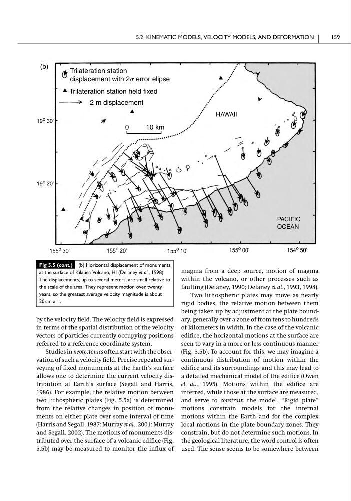
and Segall, 2002). The motions of monuments distributed over the surface of a volcanic edifice (Fig.
5.5b) may be measured to monitor the influx of
magma from a deep source, motion of magma
within the volcano, or other processes such as
faulting (Delaney, 1990; Delaney et al., 1993, 1998).
Two lithospheric plates may move as nearly
rigid bodies, the relative motion between them
being taken up by adjustment at the plate boundary, generally over a zone of from tens to hundreds
of kilometers in width. In the case of the volcanic
edifice, the horizontal motions at the surface are
seen to vary in a more or less continuous manner
(Fig. 5.5b). To account for this, we may imagine a
continuous distribution of motion within the
edifice and its surroundings and this may lead to
a detailed mechanical model of the edifice (Owen
et al., 1995). Motions within the edifice are
inferred, while those at the surface are measured,
and serve to constrain the model. “Rigid plate”
motions constrain models for the internal
motions within the Earth and for the complex
local motions in the plate boundary zones. They
constrain, but do not determine such motions. In
the geological literature, the word control is often
used. The sense seems to be somewhere between
5.2 KINEMATIC MODELS, VELOCITY MODELS, AND DEFORMATION
159
Fig 5.5 (cont.) (b) Horizontal displacement of monuments
at the surface of Kilauea Volcano, HI (Delaney et al., 1998).
The displacements, up to several meters, are small relative to
the scale of the area. They represent motion over twenty
years, so the greatest average velocity magnitude is about
20 cm a
Ϫ1
.
0
10 km
Trilateration station
displacement with 2s error elipse
2 m displacement
Trilateration station held fixed
155 o 30'
155 o 20'
155 o 10'
155 o 00'
154 o 50'
19 o 20'
19 o 30'
PACIFIC
OCEAN
HAWAII
(b)
in terms of the spatial distribution of the velocity
vectors of particles currently occupying positions
referred to a reference coordinate system.
Studies in neotectonics often start with the observation of such a velocity field. Precise repeated surveying of fixed monuments at the Earth’s surface
allows one to determine the current velocity distribution at Earth’s surface (Segall and Harris,
1986). For example, the relative motion between
two lithospheric plates (Fig. 5.5a) is determined
from the relative changes in position of monuments on either plate over some interval of time
(Harris and Segall, 1987; Murray et al., 2001; Murray
and Segall, 2002). The motions of monuments distributed over the surface of a volcanic edifice (Fig.
5.5b) may be measured to monitor the influx of
magma from a deep source, motion of magma
within the volcano, or other processes such as
faulting (Delaney, 1990; Delaney et al., 1993, 1998).
Two lithospheric plates may move as nearly
rigid bodies, the relative motion between them
being taken up by adjustment at the plate boundary, generally over a zone of from tens to hundreds
of kilometers in width. In the case of the volcanic
edifice, the horizontal motions at the surface are
seen to vary in a more or less continuous manner
(Fig. 5.5b). To account for this, we may imagine a
continuous distribution of motion within the
edifice and its surroundings and this may lead to
a detailed mechanical model of the edifice (Owen
et al., 1995). Motions within the edifice are
inferred, while those at the surface are measured,
and serve to constrain the model. “Rigid plate”
motions constrain models for the internal
motions within the Earth and for the complex
local motions in the plate boundary zones. They
constrain, but do not determine such motions. In
the geological literature, the word control is often
used. The sense seems to be somewhere between
5.2 KINEMATIC MODELS, VELOCITY MODELS, AND DEFORMATION
159
Fig 5.5 (cont.) (b) Horizontal displacement of monuments
at the surface of Kilauea Volcano, HI (Delaney et al., 1998).
The displacements, up to several meters, are small relative to
the scale of the area. They represent motion over twenty
years, so the greatest average velocity magnitude is about
20 cm a
Ϫ1
.
0
10 km
Trilateration station
displacement with 2s error elipse
2 m displacement
Trilateration station held fixed
155 o 30'
155 o 20'
155 o 10'
155 o 00'
154 o 50'
19 o 20'
19 o 30'
PACIFIC
OCEAN
HAWAII
(b)