

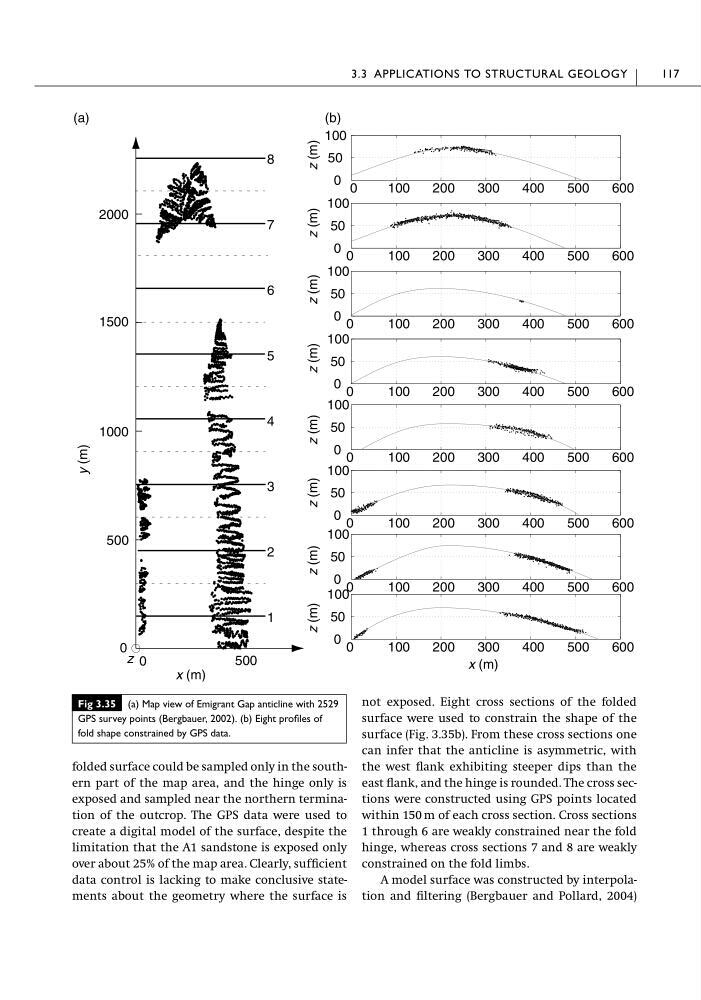
folded surface could be sampled only in the southern part of the map area, and the hinge only is
exposed and sampled near the northern termination of the outcrop. The GPS data were used to
create a digital model of the surface, despite the
limitation that the A1 sandstone is exposed only
over about 25% of the map area. Clearly, sufficient
data control is lacking to make conclusive statements about the geometry where the surface is
not exposed. Eight cross sections of the folded
surface were used to constrain the shape of the
surface (Fig. 3.35b). From these cross sections one
can infer that the anticline is asymmetric, with
the west flank exhibiting steeper dips than the
east flank, and the hinge is rounded. The cross sections were constructed using GPS points located
within 150 m of each cross section. Cross sections
1 through 6 are weakly constrained near the fold
hinge, whereas cross sections 7 and 8 are weakly
constrained on the fold limbs.
A model surface was constructed by interpolation and filtering (Bergbauer and Pollard, 2004)
3.3 APPLICATIONS TO STRUCTURAL GEOLOGY
117
Fig 3.35 (a) Map view of Emigrant Gap anticline with 2529
GPS survey points (Bergbauer, 2002). (b) Eight profiles of
fold shape constrained by GPS data.
0
500
0
500
1000
1500
2000
8
7
6
5
4
3
2
1
x (m)
y (m)
0
100
200
300
400
500
600
0
50
100
0
100
200
300
400
500
600
0
50
100
0
100
200
300
400
500
600
0
50
100
0
100
200
300
400
500
600
0
50
100
0
100
200
300
400
500
600
0
50
100
0
100
200
300
400
500
600
0
50
100
0
100
200
300
400
500
600
0
50
100
0
100
200
300
400
500
600
0
50
100
(a)
(b)
x (m)
z (m)
z (m)
z (m)
z (m)
z (m)
z (m)
z (m)
z (m)
z
exposed and sampled near the northern termination of the outcrop. The GPS data were used to
create a digital model of the surface, despite the
limitation that the A1 sandstone is exposed only
over about 25% of the map area. Clearly, sufficient
data control is lacking to make conclusive statements about the geometry where the surface is
not exposed. Eight cross sections of the folded
surface were used to constrain the shape of the
surface (Fig. 3.35b). From these cross sections one
can infer that the anticline is asymmetric, with
the west flank exhibiting steeper dips than the
east flank, and the hinge is rounded. The cross sections were constructed using GPS points located
within 150 m of each cross section. Cross sections
1 through 6 are weakly constrained near the fold
hinge, whereas cross sections 7 and 8 are weakly
constrained on the fold limbs.
A model surface was constructed by interpolation and filtering (Bergbauer and Pollard, 2004)
3.3 APPLICATIONS TO STRUCTURAL GEOLOGY
117
Fig 3.35 (a) Map view of Emigrant Gap anticline with 2529
GPS survey points (Bergbauer, 2002). (b) Eight profiles of
fold shape constrained by GPS data.
0
500
0
500
1000
1500
2000
8
7
6
5
4
3
2
1
x (m)
y (m)
0
100
200
300
400
500
600
0
50
100
0
100
200
300
400
500
600
0
50
100
0
100
200
300
400
500
600
0
50
100
0
100
200
300
400
500
600
0
50
100
0
100
200
300
400
500
600
0
50
100
0
100
200
300
400
500
600
0
50
100
0
100
200
300
400
500
600
0
50
100
0
100
200
300
400
500
600
0
50
100
(a)
(b)
x (m)
z (m)
z (m)
z (m)
z (m)
z (m)
z (m)
z (m)
z (m)
z