

544
R. B˘ atina¸ s et al.
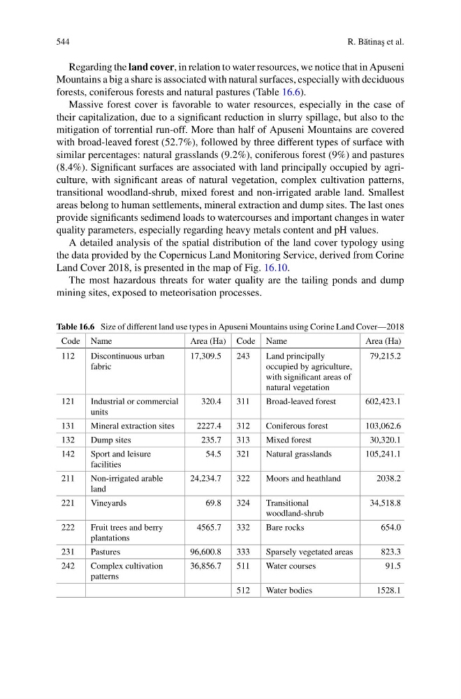
Regarding the land cover, in relation to water resources, we notice that in Apuseni
Mountains a big a share is associated with natural surfaces, especially with deciduous
forests, coniferous forests and natural pastures (Table 16.6).
Massive forest cover is favorable to water resources, especially in the case of
their capitalization, due to a significant reduction in slurry spillage, but also to the
mitigation of torrential run-off. More than half of Apuseni Mountains are covered
with broad-leaved forest (52.7%), followed by three different types of surface with
similar percentages: natural grasslands (9.2%), coniferous forest (9%) and pastures
(8.4%). Significant surfaces are associated with land principally occupied by agriculture, with significant areas of natural vegetation, complex cultivation patterns,
transitional woodland-shrub, mixed forest and non-irrigated arable land. Smallest
areas belong to human settlements, mineral extraction and dump sites. The last ones
provide significants sedimend loads to watercourses and important changes in water
quality parameters, especially regarding heavy metals content and pH values.
A detailed analysis of the spatial distribution of the land cover typology using
the data provided by the Copernicus Land Monitoring Service, derived from Corine
Land Cover 2018, is presented in the map of Fig. 16.10.
The most hazardous threats for water quality are the tailing ponds and dump
mining sites, exposed to meteorisation processes.
Table 16.6 Size of different land use types in Apuseni Mountains using Corine Land Cover—2018
Code Name
Area (Ha) Code Name
Area (Ha)
112
Discontinuous urban
fabric
17,309.5
243
Land principally
occupied by agriculture,
with significant areas of
natural vegetation
79,215.2
121
Industrial or commercial
units
320.4
311
Broad-leaved forest
602,423.1
131
Mineral extraction sites
2227.4
312
Coniferous forest
103,062.6
132
Dump sites
235.7
313
Mixed forest
30,320.1
142
Sport and leisure
facilities
54.5
321
Natural grasslands
105,241.1
211
Non-irrigated arable
land
24,234.7
322
Moors and heathland
2038.2
221
Vineyards
69.8
324
Transitional
woodland-shrub
34,518.8
222
Fruit trees and berry
plantations
4565.7
332
Bare rocks
654.0
231
Pastures
96,600.8
333
Sparsely vegetated areas
823.3
242
Complex cultivation
patterns
36,856.7
511
Water courses
91.5
512
Water bodies
1528.1
R. B˘ atina¸ s et al.
Regarding the land cover, in relation to water resources, we notice that in Apuseni
Mountains a big a share is associated with natural surfaces, especially with deciduous
forests, coniferous forests and natural pastures (Table 16.6).
Massive forest cover is favorable to water resources, especially in the case of
their capitalization, due to a significant reduction in slurry spillage, but also to the
mitigation of torrential run-off. More than half of Apuseni Mountains are covered
with broad-leaved forest (52.7%), followed by three different types of surface with
similar percentages: natural grasslands (9.2%), coniferous forest (9%) and pastures
(8.4%). Significant surfaces are associated with land principally occupied by agriculture, with significant areas of natural vegetation, complex cultivation patterns,
transitional woodland-shrub, mixed forest and non-irrigated arable land. Smallest
areas belong to human settlements, mineral extraction and dump sites. The last ones
provide significants sedimend loads to watercourses and important changes in water
quality parameters, especially regarding heavy metals content and pH values.
A detailed analysis of the spatial distribution of the land cover typology using
the data provided by the Copernicus Land Monitoring Service, derived from Corine
Land Cover 2018, is presented in the map of Fig. 16.10.
The most hazardous threats for water quality are the tailing ponds and dump
mining sites, exposed to meteorisation processes.
Table 16.6 Size of different land use types in Apuseni Mountains using Corine Land Cover—2018
Code Name
Area (Ha) Code Name
Area (Ha)
112
Discontinuous urban
fabric
17,309.5
243
Land principally
occupied by agriculture,
with significant areas of
natural vegetation
79,215.2
121
Industrial or commercial
units
320.4
311
Broad-leaved forest
602,423.1
131
Mineral extraction sites
2227.4
312
Coniferous forest
103,062.6
132
Dump sites
235.7
313
Mixed forest
30,320.1
142
Sport and leisure
facilities
54.5
321
Natural grasslands
105,241.1
211
Non-irrigated arable
land
24,234.7
322
Moors and heathland
2038.2
221
Vineyards
69.8
324
Transitional
woodland-shrub
34,518.8
222
Fruit trees and berry
plantations
4565.7
332
Bare rocks
654.0
231
Pastures
96,600.8
333
Sparsely vegetated areas
823.3
242
Complex cultivation
patterns
36,856.7
511
Water courses
91.5
512
Water bodies
1528.1