

16 Water Resources from Apuseni Mountains …
525
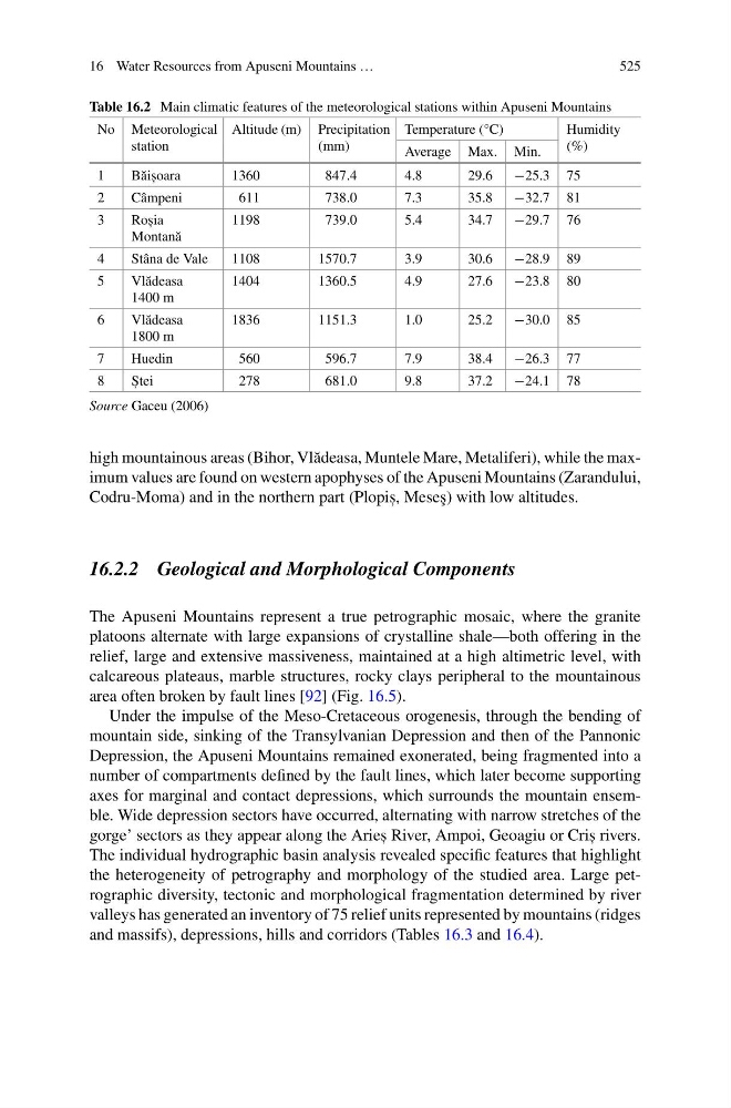
Table 16.2 Main climatic features of the meteorological stations within Apuseni Mountains
No Meteorological
station
Altitude (m) Precipitation
(mm)
Temperature (°C)
Humidity
(%)
Average Max. Min.
1
B˘ ais , oara
1360
847.4
4.8
29.6
−25.3 75
2
Câmpeni
611
738.0
7.3
35.8
−32.7 81
3
Ros , ia
Montan˘ a
1198
739.0
5.4
34.7
−29.7 76
4
Stâna de Vale
1108
1570.7
3.9
30.6
−28.9 89
5
Vl˘ adeasa
1400 m
1404
1360.5
4.9
27.6
−23.8 80
6
Vl˘ adeasa
1800 m
1836
1151.3
1.0
25.2
−30.0 85
7
Huedin
560
596.7
7.9
38.4
−26.3 77
8
S , tei
278
681.0
9.8
37.2
−24.1 78
Source Gaceu (2006)
high mountainous areas (Bihor, Vl˘ adeasa, Muntele Mare, Metaliferi), while the maximum values are found on western apophyses of the Apuseni Mountains (Zarandului,
Codru-Moma) and in the northern part (Plopis , , Mese¸ s) with low altitudes.
16.2.2 Geological and Morphological Components
The Apuseni Mountains represent a true petrographic mosaic, where the granite
platoons alternate with large expansions of crystalline shale—both offering in the
relief, large and extensive massiveness, maintained at a high altimetric level, with
calcareous plateaus, marble structures, rocky clays peripheral to the mountainous
area often broken by fault lines [92] (Fig. 16.5).
Under the impulse of the Meso-Cretaceous orogenesis, through the bending of
mountain side, sinking of the Transylvanian Depression and then of the Pannonic
Depression, the Apuseni Mountains remained exonerated, being fragmented into a
number of compartments defined by the fault lines, which later become supporting
axes for marginal and contact depressions, which surrounds the mountain ensemble. Wide depression sectors have occurred, alternating with narrow stretches of the
gorge’ sectors as they appear along the Aries , River, Ampoi, Geoagiu or Cris , rivers.
The individual hydrographic basin analysis revealed specific features that highlight
the heterogeneity of petrography and morphology of the studied area. Large petrographic diversity, tectonic and morphological fragmentation determined by river
valleys has generated an inventory of 75 relief units represented by mountains (ridges
and massifs), depressions, hills and corridors (Tables 16.3 and 16.4).
525
Table 16.2 Main climatic features of the meteorological stations within Apuseni Mountains
No Meteorological
station
Altitude (m) Precipitation
(mm)
Temperature (°C)
Humidity
(%)
Average Max. Min.
1
B˘ ais , oara
1360
847.4
4.8
29.6
−25.3 75
2
Câmpeni
611
738.0
7.3
35.8
−32.7 81
3
Ros , ia
Montan˘ a
1198
739.0
5.4
34.7
−29.7 76
4
Stâna de Vale
1108
1570.7
3.9
30.6
−28.9 89
5
Vl˘ adeasa
1400 m
1404
1360.5
4.9
27.6
−23.8 80
6
Vl˘ adeasa
1800 m
1836
1151.3
1.0
25.2
−30.0 85
7
Huedin
560
596.7
7.9
38.4
−26.3 77
8
S , tei
278
681.0
9.8
37.2
−24.1 78
Source Gaceu (2006)
high mountainous areas (Bihor, Vl˘ adeasa, Muntele Mare, Metaliferi), while the maximum values are found on western apophyses of the Apuseni Mountains (Zarandului,
Codru-Moma) and in the northern part (Plopis , , Mese¸ s) with low altitudes.
16.2.2 Geological and Morphological Components
The Apuseni Mountains represent a true petrographic mosaic, where the granite
platoons alternate with large expansions of crystalline shale—both offering in the
relief, large and extensive massiveness, maintained at a high altimetric level, with
calcareous plateaus, marble structures, rocky clays peripheral to the mountainous
area often broken by fault lines [92] (Fig. 16.5).
Under the impulse of the Meso-Cretaceous orogenesis, through the bending of
mountain side, sinking of the Transylvanian Depression and then of the Pannonic
Depression, the Apuseni Mountains remained exonerated, being fragmented into a
number of compartments defined by the fault lines, which later become supporting
axes for marginal and contact depressions, which surrounds the mountain ensemble. Wide depression sectors have occurred, alternating with narrow stretches of the
gorge’ sectors as they appear along the Aries , River, Ampoi, Geoagiu or Cris , rivers.
The individual hydrographic basin analysis revealed specific features that highlight
the heterogeneity of petrography and morphology of the studied area. Large petrographic diversity, tectonic and morphological fragmentation determined by river
valleys has generated an inventory of 75 relief units represented by mountains (ridges
and massifs), depressions, hills and corridors (Tables 16.3 and 16.4).