

524
R. B˘ atina¸ s et al.
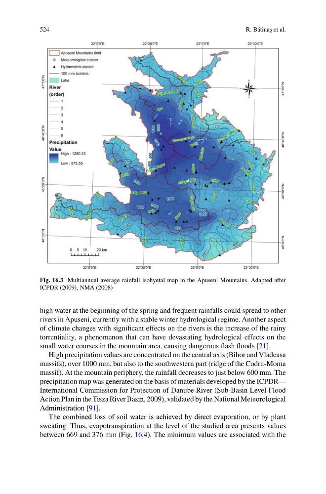
Fig. 16.3 Multiannual average rainfall isohyetal map in the Apuseni Mountains. Adapted after
ICPDR (2009), NMA (2008)
high water at the beginning of the spring and frequent rainfalls could spread to other
rivers in Apuseni, currently with a stable winter hydrological regime. Another aspect
of climate changes with significant effects on the rivers is the increase of the rainy
torrentiality, a phenomenon that can have devastating hydrological effects on the
small water courses in the mountain area, causing dangerous flash floods [21].
High precipitation values are concentrated on the central axis (Bihor and Vladeasa
massifs), over 1000 mm, but also to the southwestern part (ridge of the Codru-Moma
massif). At the mountain periphery, the rainfall decreases to just below 600 mm. The
precipitation map was generated on the basis of materials developed by the ICPDR—
International Commission for Protection of Danube River (Sub-Basin Level Flood
Action Plan in the Tisza River Basin, 2009), validated by the National Meteorological
Administration [91].
The combined loss of soil water is achieved by direct evaporation, or by plant
sweating. Thus, evapotranspiration at the level of the studied area presents values
between 669 and 376 mm (Fig. 16.4). The minimum values are associated with the
R. B˘ atina¸ s et al.
Fig. 16.3 Multiannual average rainfall isohyetal map in the Apuseni Mountains. Adapted after
ICPDR (2009), NMA (2008)
high water at the beginning of the spring and frequent rainfalls could spread to other
rivers in Apuseni, currently with a stable winter hydrological regime. Another aspect
of climate changes with significant effects on the rivers is the increase of the rainy
torrentiality, a phenomenon that can have devastating hydrological effects on the
small water courses in the mountain area, causing dangerous flash floods [21].
High precipitation values are concentrated on the central axis (Bihor and Vladeasa
massifs), over 1000 mm, but also to the southwestern part (ridge of the Codru-Moma
massif). At the mountain periphery, the rainfall decreases to just below 600 mm. The
precipitation map was generated on the basis of materials developed by the ICPDR—
International Commission for Protection of Danube River (Sub-Basin Level Flood
Action Plan in the Tisza River Basin, 2009), validated by the National Meteorological
Administration [91].
The combined loss of soil water is achieved by direct evaporation, or by plant
sweating. Thus, evapotranspiration at the level of the studied area presents values
between 669 and 376 mm (Fig. 16.4). The minimum values are associated with the