

16 Water Resources from Apuseni Mountains …
521
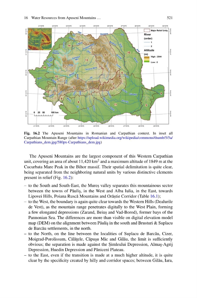
Fig. 16.2 The Apuseni Mountains in Romanian and Carpathian context. In inset all
Carpathian Mountain Range (after https://upload.wikimedia.org/wikipedia/commons/thumb/5/5a/
Carpathians_dem.jpg/580px-Carpathians_dem.jpg)
The Apuseni Mountains are the largest component of this Western Carpathian
unit, covering an area of about 11,420 km
2 and a maximum altitude of 1849 m at the
Cucurbata Mare Peak in the Bihor massif. Their spatial delimitation is quite clear,
being separated from the neighboring natural units by various distinctive elements
present in relief (Fig. 16.2):
– to the South and South-East, the Mures , valley separates this mountainous sector
between the towns of P˘ auli¸ s, in the West and Alba Iulia, in the East, towards
Lipovei Hills, Poiana Rusc˘ a Mountains and Or˘ as , tie Corridor (Table 16.1);
– to the West, the boundary is again quite clear towards the Western Hills (Dealurile
de Vest), as the mountain range penetrates digitally to the West Plain, forming
a few elongated depressions (Zarand, Beius , and Vad-Borod), former bays of the
Pannonian Sea. The differences are more than visible on digital elevation model
map (DEM) on the alignment between P˘ auli¸ s in the south and Brusturi & Suplacu
de Barc˘ au settlements, in the north.
– to the North, on the line between the localities of Suplacu de Barc˘ au, Cizer,
Moigrad-Porolissum, C˘ al˘ a¸ tele, C˘ apu¸ su Mic and Gil˘ au, the limit is sufficiently
obvious; the separation is made against the S , imleului Depression, Alma¸ s-Agrij
Depression, Huedin Depression and P˘ aniceni Plateau.
– to the East, even if the transition is made at a much higher altitude, it is quite
clear by the specificity created by hilly and corridor spaces; between Gil˘ au, Iara,
521
Fig. 16.2 The Apuseni Mountains in Romanian and Carpathian context. In inset all
Carpathian Mountain Range (after https://upload.wikimedia.org/wikipedia/commons/thumb/5/5a/
Carpathians_dem.jpg/580px-Carpathians_dem.jpg)
The Apuseni Mountains are the largest component of this Western Carpathian
unit, covering an area of about 11,420 km
2 and a maximum altitude of 1849 m at the
Cucurbata Mare Peak in the Bihor massif. Their spatial delimitation is quite clear,
being separated from the neighboring natural units by various distinctive elements
present in relief (Fig. 16.2):
– to the South and South-East, the Mures , valley separates this mountainous sector
between the towns of P˘ auli¸ s, in the West and Alba Iulia, in the East, towards
Lipovei Hills, Poiana Rusc˘ a Mountains and Or˘ as , tie Corridor (Table 16.1);
– to the West, the boundary is again quite clear towards the Western Hills (Dealurile
de Vest), as the mountain range penetrates digitally to the West Plain, forming
a few elongated depressions (Zarand, Beius , and Vad-Borod), former bays of the
Pannonian Sea. The differences are more than visible on digital elevation model
map (DEM) on the alignment between P˘ auli¸ s in the south and Brusturi & Suplacu
de Barc˘ au settlements, in the north.
– to the North, on the line between the localities of Suplacu de Barc˘ au, Cizer,
Moigrad-Porolissum, C˘ al˘ a¸ tele, C˘ apu¸ su Mic and Gil˘ au, the limit is sufficiently
obvious; the separation is made against the S , imleului Depression, Alma¸ s-Agrij
Depression, Huedin Depression and P˘ aniceni Plateau.
– to the East, even if the transition is made at a much higher altitude, it is quite
clear by the specificity created by hilly and corridor spaces; between Gil˘ au, Iara,