

520
R. B˘ atina¸ s et al.
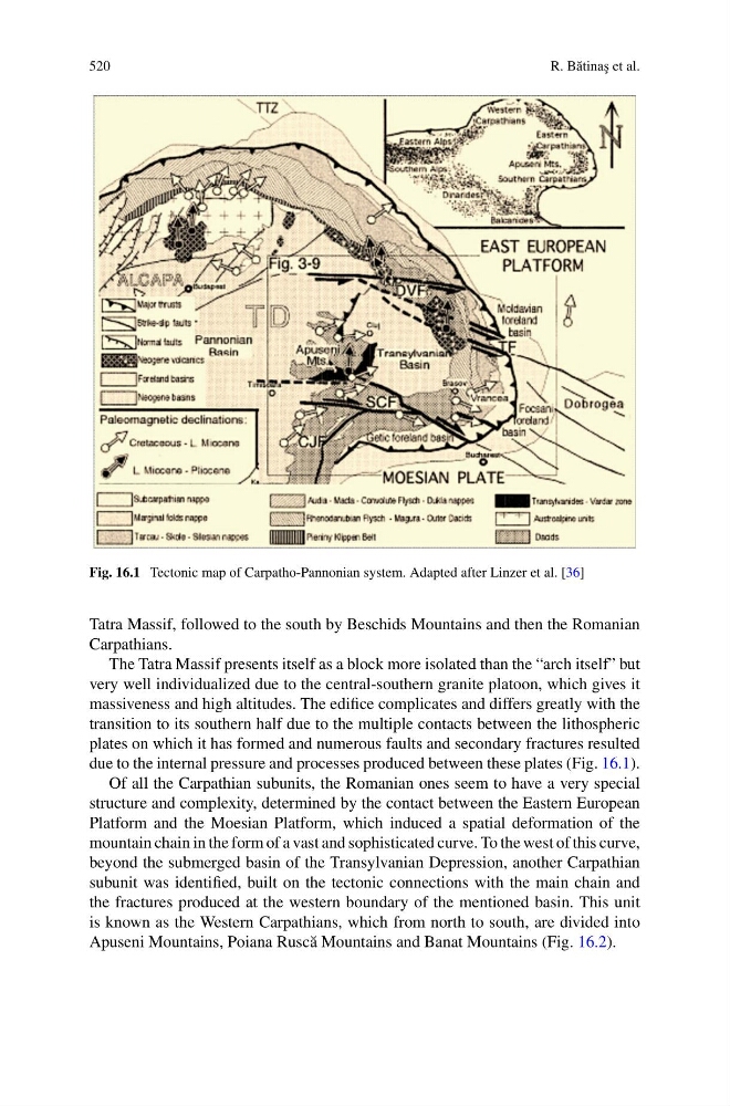
Fig. 16.1 Tectonic map of Carpatho-Pannonian system. Adapted after Linzer et al. [36]
Tatra Massif, followed to the south by Beschids Mountains and then the Romanian
Carpathians.
The Tatra Massif presents itself as a block more isolated than the “arch itself” but
very well individualized due to the central-southern granite platoon, which gives it
massiveness and high altitudes. The edifice complicates and differs greatly with the
transition to its southern half due to the multiple contacts between the lithospheric
plates on which it has formed and numerous faults and secondary fractures resulted
due to the internal pressure and processes produced between these plates (Fig. 16.1).
Of all the Carpathian subunits, the Romanian ones seem to have a very special
structure and complexity, determined by the contact between the Eastern European
Platform and the Moesian Platform, which induced a spatial deformation of the
mountain chain in the form of a vast and sophisticated curve. To the west of this curve,
beyond the submerged basin of the Transylvanian Depression, another Carpathian
subunit was identified, built on the tectonic connections with the main chain and
the fractures produced at the western boundary of the mentioned basin. This unit
is known as the Western Carpathians, which from north to south, are divided into
Apuseni Mountains, Poiana Rusc˘ a Mountains and Banat Mountains (Fig. 16.2).
R. B˘ atina¸ s et al.
Fig. 16.1 Tectonic map of Carpatho-Pannonian system. Adapted after Linzer et al. [36]
Tatra Massif, followed to the south by Beschids Mountains and then the Romanian
Carpathians.
The Tatra Massif presents itself as a block more isolated than the “arch itself” but
very well individualized due to the central-southern granite platoon, which gives it
massiveness and high altitudes. The edifice complicates and differs greatly with the
transition to its southern half due to the multiple contacts between the lithospheric
plates on which it has formed and numerous faults and secondary fractures resulted
due to the internal pressure and processes produced between these plates (Fig. 16.1).
Of all the Carpathian subunits, the Romanian ones seem to have a very special
structure and complexity, determined by the contact between the Eastern European
Platform and the Moesian Platform, which induced a spatial deformation of the
mountain chain in the form of a vast and sophisticated curve. To the west of this curve,
beyond the submerged basin of the Transylvanian Depression, another Carpathian
subunit was identified, built on the tectonic connections with the main chain and
the fractures produced at the western boundary of the mentioned basin. This unit
is known as the Western Carpathians, which from north to south, are divided into
Apuseni Mountains, Poiana Rusc˘ a Mountains and Banat Mountains (Fig. 16.2).