

12 Water Resources from Romanian Upper Tisa Basin
413
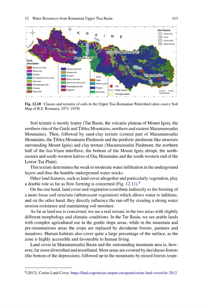
Fig. 12.10 Classes and textures of soils in the Upper Tisa Romanian Watershed (data source Soil
Map of R.S. Romania, 1971–1979)
Soil texture is mostly loamy (Tur Basin, the volcanic plateau of Mount Ignis , , the
northern rim of the Gutâi and T , ibles , Mountains, northern and eastern Maramures , ului
Mountains). Then, followed by sand-clay texture (central part of Maramures , ului
Mountains, the T , ibles , Mountains Piedmont and the periferic piedmont-like structure
surrounding Mount Ignis , ) and clay texture (Maramures , ului Piedmont, the northern
half of the Iza-Vis , eu interfluve, the bottom of the Mount Ignis , abrupt, the northeastern and south-western halves of Oas , Mountains and the south-western end of the
Lower Tur Plain).
This texture determines the weak to moderate water infiltration in the underground
layers and thus the humble underground water stocks.
Other land features, such as land cover altogether and particularly vegetation, play
a double role as far as flow forming is concerned (Fig. 12.11).
8
On the one hand, land cover and vegetation contribute indirectly to the forming of
a more loose soil structure (arborescent vegetation) which allows water to infiltrate,
and on the other hand, they directly influence the run-off by creating a strong water
erosion resistance and maintaining soil moisture.
As far as land use is concerned, we see a real mosaic in the two areas with slightly
different morphology and climatic conditions. In the Tur Basin, we see arable lands
with complex agricultural use in the gentle slope areas, while in the mountain and
pre-mountainous areas the crops are replaced by deciduous forests, pastures and
meadows. Human habitats also cover quite a large percentage of the surface, as the
zone is highly accessible and favourable to human living.
Land cover in Maramures , ului Basin and the surrounding mountain area is, however, far more diversified and tessellated. Most areas are covered by deciduous forests
(the bottom of the depression), followed up in the mountains by mixed forests (espe8 (2012), Corine Land Cover, https://land.copernicus.eu/pan-european/corine-land-cover/clc-2012
413
Fig. 12.10 Classes and textures of soils in the Upper Tisa Romanian Watershed (data source Soil
Map of R.S. Romania, 1971–1979)
Soil texture is mostly loamy (Tur Basin, the volcanic plateau of Mount Ignis , , the
northern rim of the Gutâi and T , ibles , Mountains, northern and eastern Maramures , ului
Mountains). Then, followed by sand-clay texture (central part of Maramures , ului
Mountains, the T , ibles , Mountains Piedmont and the periferic piedmont-like structure
surrounding Mount Ignis , ) and clay texture (Maramures , ului Piedmont, the northern
half of the Iza-Vis , eu interfluve, the bottom of the Mount Ignis , abrupt, the northeastern and south-western halves of Oas , Mountains and the south-western end of the
Lower Tur Plain).
This texture determines the weak to moderate water infiltration in the underground
layers and thus the humble underground water stocks.
Other land features, such as land cover altogether and particularly vegetation, play
a double role as far as flow forming is concerned (Fig. 12.11).
8
On the one hand, land cover and vegetation contribute indirectly to the forming of
a more loose soil structure (arborescent vegetation) which allows water to infiltrate,
and on the other hand, they directly influence the run-off by creating a strong water
erosion resistance and maintaining soil moisture.
As far as land use is concerned, we see a real mosaic in the two areas with slightly
different morphology and climatic conditions. In the Tur Basin, we see arable lands
with complex agricultural use in the gentle slope areas, while in the mountain and
pre-mountainous areas the crops are replaced by deciduous forests, pastures and
meadows. Human habitats also cover quite a large percentage of the surface, as the
zone is highly accessible and favourable to human living.
Land cover in Maramures , ului Basin and the surrounding mountain area is, however, far more diversified and tessellated. Most areas are covered by deciduous forests
(the bottom of the depression), followed up in the mountains by mixed forests (espe8 (2012), Corine Land Cover, https://land.copernicus.eu/pan-european/corine-land-cover/clc-2012