

412
G. ¸
Serban et al.
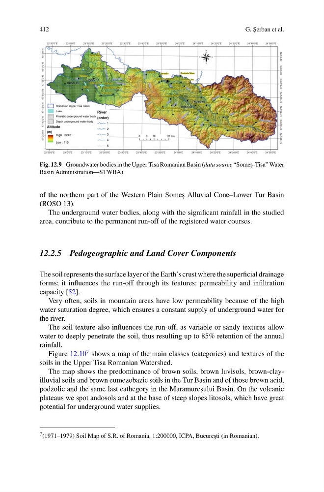
Fig. 12.9 Groundwater bodies in the Upper Tisa Romanian Basin (data source “Somes , -Tisa” Water
Basin Administration—STWBA)
of the northern part of the Western Plain Somes , Alluvial Cone–Lower Tur Basin
(ROSO 13).
The underground water bodies, along with the significant rainfall in the studied
area, contribute to the permanent run-off of the registered water courses.
12.2.5 Pedogeographic and Land Cover Components
The soil represents the surface layer of the Earth’s crust where the superficial drainage
forms; it influences the run-off through its features: permeability and infiltration
capacity [52].
Very often, soils in mountain areas have low permeability because of the high
water saturation degree, which ensures a constant supply of underground water for
the river.
The soil texture also influences the run-off, as variable or sandy textures allow
water to deeply penetrate the soil, thus resulting up to 85% retention of the annual
rainfall.
Figure 12.10
7 shows a map of the main classes (categories) and textures of the
soils in the Upper Tisa Romanian Watershed.
The map shows the predominance of brown soils, brown luvisols, brown-clayilluvial soils and brown eumezobazic soils in the Tur Basin and of those brown acid,
podzolic and the same last cathegory in the Maramures , ului Basin. On the volcanic
plateaus we spot andosols and at the base of steep slopes litosols, which have great
potential for underground water supplies.
7 (1971–1979) Soil Map of S.R. of Romania, 1:200000, ICPA, Bucure¸ sti (in Romanian).
G. ¸
Serban et al.
Fig. 12.9 Groundwater bodies in the Upper Tisa Romanian Basin (data source “Somes , -Tisa” Water
Basin Administration—STWBA)
of the northern part of the Western Plain Somes , Alluvial Cone–Lower Tur Basin
(ROSO 13).
The underground water bodies, along with the significant rainfall in the studied
area, contribute to the permanent run-off of the registered water courses.
12.2.5 Pedogeographic and Land Cover Components
The soil represents the surface layer of the Earth’s crust where the superficial drainage
forms; it influences the run-off through its features: permeability and infiltration
capacity [52].
Very often, soils in mountain areas have low permeability because of the high
water saturation degree, which ensures a constant supply of underground water for
the river.
The soil texture also influences the run-off, as variable or sandy textures allow
water to deeply penetrate the soil, thus resulting up to 85% retention of the annual
rainfall.
Figure 12.10
7 shows a map of the main classes (categories) and textures of the
soils in the Upper Tisa Romanian Watershed.
The map shows the predominance of brown soils, brown luvisols, brown-clayilluvial soils and brown eumezobazic soils in the Tur Basin and of those brown acid,
podzolic and the same last cathegory in the Maramures , ului Basin. On the volcanic
plateaus we spot andosols and at the base of steep slopes litosols, which have great
potential for underground water supplies.
7 (1971–1979) Soil Map of S.R. of Romania, 1:200000, ICPA, Bucure¸ sti (in Romanian).