

410
G. ¸
Serban et al.
The Tur river basin has a certain right assimetry, where the vigorous tributaries such as Valea Rea, Lechincioara, Turt , etc., drain the volcanic slopes of
Oas , Mountains.
The density of the hydrographic network in the romanian watershed has values
that range from 0.3 km/km
2 in the lower parts of the studied area to 0.8 km/km
2 in
the mountain area.
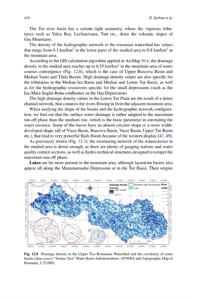
According to the GIS calculation algorithm applied in ArcMap 10.x, the drainage
density in the studied area reaches up to 6.55 km/km
2 in the mountain area of water
courses convergence (Fig. 12.8), which is the case of Upper Ruscova Basin and
Median Vaser and T , âs , la Basins. High drainage density values are also specific for
the tributaries in the Median Iza Basin and Median and Lower Tur Basin, as well
as for the hydrographic crossovers specific for the small depressions (such as the
Iza-Mara-S , ug˘ au-Rona confluence or the Oas , Depression).
The high drainage density values in the Lower Tur Plain are the result of a dense
channel network, that connects the rivers flowing in from the adjacent mountain area.
When studying the shape of the basins and the hydrographic network configuration, we find out that the surface water drainage is rather adapted to the maximum
run-off phase than the medium one, which is the basic parameter in estimating the
water resource. Some of the basins have an almost circular shape or a more widthdeveloped shape (all of Vis , eu Basin, Ruscova Basin, Vaser Basin, Upper Tur Basin
etc.), that lead to very powerful flash-floods because of the western display [47, 49].
As previously shown (Fig. 12.3), the monitoring network of the watercourses in
the studied area is dense enough, as there are plenty of gauging stations and water
quality control sections, as well as hydro-technical structures designed to temper the
maximum run-off phase.
Lakes are far more present in the mountain area, although lacustrine basins also
appear all along the Maramures , ului Depression or in the Tur Basin. Their origins
Fig. 12.8 Drainage density in the Upper Tisa Romanian Watershed and the circularity of some
basins (data source “Somes , -Tisa” Water Basin Administration—STWBA and Topographic Map of
Romania, 1:25,000)
G. ¸
Serban et al.
The Tur river basin has a certain right assimetry, where the vigorous tributaries such as Valea Rea, Lechincioara, Turt , etc., drain the volcanic slopes of
Oas , Mountains.
The density of the hydrographic network in the romanian watershed has values
that range from 0.3 km/km
2 in the lower parts of the studied area to 0.8 km/km
2 in
the mountain area.
According to the GIS calculation algorithm applied in ArcMap 10.x, the drainage
density in the studied area reaches up to 6.55 km/km
2 in the mountain area of water
courses convergence (Fig. 12.8), which is the case of Upper Ruscova Basin and
Median Vaser and T , âs , la Basins. High drainage density values are also specific for
the tributaries in the Median Iza Basin and Median and Lower Tur Basin, as well
as for the hydrographic crossovers specific for the small depressions (such as the
Iza-Mara-S , ug˘ au-Rona confluence or the Oas , Depression).
The high drainage density values in the Lower Tur Plain are the result of a dense
channel network, that connects the rivers flowing in from the adjacent mountain area.
When studying the shape of the basins and the hydrographic network configuration, we find out that the surface water drainage is rather adapted to the maximum
run-off phase than the medium one, which is the basic parameter in estimating the
water resource. Some of the basins have an almost circular shape or a more widthdeveloped shape (all of Vis , eu Basin, Ruscova Basin, Vaser Basin, Upper Tur Basin
etc.), that lead to very powerful flash-floods because of the western display [47, 49].
As previously shown (Fig. 12.3), the monitoring network of the watercourses in
the studied area is dense enough, as there are plenty of gauging stations and water
quality control sections, as well as hydro-technical structures designed to temper the
maximum run-off phase.
Lakes are far more present in the mountain area, although lacustrine basins also
appear all along the Maramures , ului Depression or in the Tur Basin. Their origins
Fig. 12.8 Drainage density in the Upper Tisa Romanian Watershed and the circularity of some
basins (data source “Somes , -Tisa” Water Basin Administration—STWBA and Topographic Map of
Romania, 1:25,000)