

12 Water Resources from Romanian Upper Tisa Basin
409
12.2.4 Hydrographic Component
The hydrographic component is also influenced by the geological substrate, made of
hard rocks in the mountain area or clay in the hilly area, and by rainfall, which is of
significant quantity.
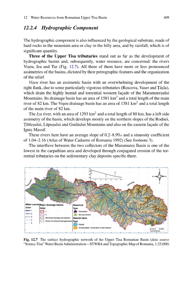
Three of the Upper Tisa tributaries stand out as far as the development of
hydrographic basins and, subsequently, water resource, are concerned: the rivers
Vis , eu, Iza and Tur (Fig. 12.7). All three of them have more or less pronounced
assimetries of the basins, dictated by their petrographic features and the organization
of the relief.
Vis , eu river has an assimetric basin with an overwhelming development of the
right flank, due to some particularly vigorous tributaries (Ruscova, Vaser and T , âs , la),
which drain the highly humid and torrential western façade of the Maramures , ului
Mountains. Its drainage basin has an area of 1581 km
2 and a total length of the main
river of 82 km. The Vi¸ seu drainage basin has an area of 1581 km
2 and a total length
of the main river of 82 km.
The Iza river, with an area of 1293 km
2 and a total length of 80 km, has a left side
assimetry of the basin, which develops mostly on the northern slopes of the Rodnei,
T , ibles , ului, L˘ apus , ului and Gutâiului Mountains and also on the eastern façade of the
Ignis , Massif.
These rivers here have an average slope of 0.2–8.9‰ and a sinuosity coefficient
of 1.04–2.16 (Atlas of Water Cadastre of Romania 1992) (See footnote 3).
The interfluve between the two collectors of the Maramures , Basin is one of the
lowest in the carpathian area and developed through conjugated erosion of the torrential tributaries on the sedimentary clay deposits specific there.
Fig. 12.7 The surface hydrographic network of the Upper Tisa Romanian Basin (data source
“Somes , -Tisa” Water Basin Administration—STWBA and Topographic Map of Romania, 1:25,000)
409
12.2.4 Hydrographic Component
The hydrographic component is also influenced by the geological substrate, made of
hard rocks in the mountain area or clay in the hilly area, and by rainfall, which is of
significant quantity.
Three of the Upper Tisa tributaries stand out as far as the development of
hydrographic basins and, subsequently, water resource, are concerned: the rivers
Vis , eu, Iza and Tur (Fig. 12.7). All three of them have more or less pronounced
assimetries of the basins, dictated by their petrographic features and the organization
of the relief.
Vis , eu river has an assimetric basin with an overwhelming development of the
right flank, due to some particularly vigorous tributaries (Ruscova, Vaser and T , âs , la),
which drain the highly humid and torrential western façade of the Maramures , ului
Mountains. Its drainage basin has an area of 1581 km
2 and a total length of the main
river of 82 km. The Vi¸ seu drainage basin has an area of 1581 km
2 and a total length
of the main river of 82 km.
The Iza river, with an area of 1293 km
2 and a total length of 80 km, has a left side
assimetry of the basin, which develops mostly on the northern slopes of the Rodnei,
T , ibles , ului, L˘ apus , ului and Gutâiului Mountains and also on the eastern façade of the
Ignis , Massif.
These rivers here have an average slope of 0.2–8.9‰ and a sinuosity coefficient
of 1.04–2.16 (Atlas of Water Cadastre of Romania 1992) (See footnote 3).
The interfluve between the two collectors of the Maramures , Basin is one of the
lowest in the carpathian area and developed through conjugated erosion of the torrential tributaries on the sedimentary clay deposits specific there.
Fig. 12.7 The surface hydrographic network of the Upper Tisa Romanian Basin (data source
“Somes , -Tisa” Water Basin Administration—STWBA and Topographic Map of Romania, 1:25,000)