

408
G. ¸
Serban et al.
According to the maps above, the studied area can be characterized as a high
rainfall one, especially in the upper mountain basin that generates the runoff. The
rainfall values range from 695 mm in the bottom of the Maramures , ului Depression
to 1430 mm on the highest peaks of the South and South-East Vis , eu River Basin,
according to the Sub-Basin Level Flood Action Plan Tisza River Basin (Sub-Basin
Level Flood Action Plan in the Tisza River Basin), validated by the National Meteorological Administration (NMA).
For the first area, the rainfall can easily accumulate in the thick deposits of the
large Tisa-Iza confluence lane, but for the second, the surface runoff has a significant torrential feature, and drains very rapidly on the steep slopes of Rodnei and
Maramures , ului Mountains, which is obviously not in favour of the underground
water accumulation.
As a matter of fact, the correlations between rainfall and altitude allow the identification of four categories and four areas of validity for the average rainfall, which
confirm the gradual reduction of the quantities from East to West. The highest values
reduce from about 1430 mm on the northern slopes of the Rodnei Mountains and The
Toroiaga Massif Ridge to 1260 mm in the Oas , Low Mountains. As we will further
see, these areas of rainfall validity match almost identically the runoff validity areas,
which allows us to estimate the balance of the water resource.
The significant rainfall quantities place the studied area in the high humidity zone,
or even in the excessive one, in some parts of the river basin [52].
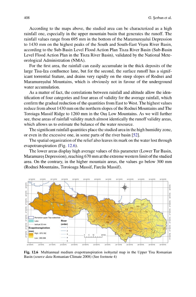
The spatial organization of the relief also leaves its mark on the water lost through
evapotranspiration (Fig. 12.6).
The lower areas display high average values of this parameter (Lower Tur Basin,
Maramures , Depression), reaching 670 mm at the extreme western limit of the studied
area. On the contrary, in the higher mountain areas, the values go below 300 mm
(Rodnei Mountains, Toroioaga Massif, Farc˘ au Massif).
Fig. 12.6 Multiannual medium evapotranspiration isohyetal map in the Upper Tisa Romanian
Basin (source data Romanian Climate 2008) (See footnote 4)
G. ¸
Serban et al.
According to the maps above, the studied area can be characterized as a high
rainfall one, especially in the upper mountain basin that generates the runoff. The
rainfall values range from 695 mm in the bottom of the Maramures , ului Depression
to 1430 mm on the highest peaks of the South and South-East Vis , eu River Basin,
according to the Sub-Basin Level Flood Action Plan Tisza River Basin (Sub-Basin
Level Flood Action Plan in the Tisza River Basin), validated by the National Meteorological Administration (NMA).
For the first area, the rainfall can easily accumulate in the thick deposits of the
large Tisa-Iza confluence lane, but for the second, the surface runoff has a significant torrential feature, and drains very rapidly on the steep slopes of Rodnei and
Maramures , ului Mountains, which is obviously not in favour of the underground
water accumulation.
As a matter of fact, the correlations between rainfall and altitude allow the identification of four categories and four areas of validity for the average rainfall, which
confirm the gradual reduction of the quantities from East to West. The highest values
reduce from about 1430 mm on the northern slopes of the Rodnei Mountains and The
Toroiaga Massif Ridge to 1260 mm in the Oas , Low Mountains. As we will further
see, these areas of rainfall validity match almost identically the runoff validity areas,
which allows us to estimate the balance of the water resource.
The significant rainfall quantities place the studied area in the high humidity zone,
or even in the excessive one, in some parts of the river basin [52].
The spatial organization of the relief also leaves its mark on the water lost through
evapotranspiration (Fig. 12.6).
The lower areas display high average values of this parameter (Lower Tur Basin,
Maramures , Depression), reaching 670 mm at the extreme western limit of the studied
area. On the contrary, in the higher mountain areas, the values go below 300 mm
(Rodnei Mountains, Toroioaga Massif, Farc˘ au Massif).
Fig. 12.6 Multiannual medium evapotranspiration isohyetal map in the Upper Tisa Romanian
Basin (source data Romanian Climate 2008) (See footnote 4)