

11 Monitoring and Management of Water in the Siret River …
357
Siret Water Basin
AdministraƟon
Water Management
System Bacau
Water Management
System Suceava
Water Management
System Neamt
Water Management
System Vrancea
Hydrological
StaƟon
Suceava
Hydrological
StaƟon
Bacau
Hydrological
StaƟon
Vatra Dornei
Hydrological
StaƟon
Stulpicani
Hydrological
StaƟon
OnesƟ
Hydrological
StaƟon
Piatra Neamt
Hydrological
StaƟon
Focsani
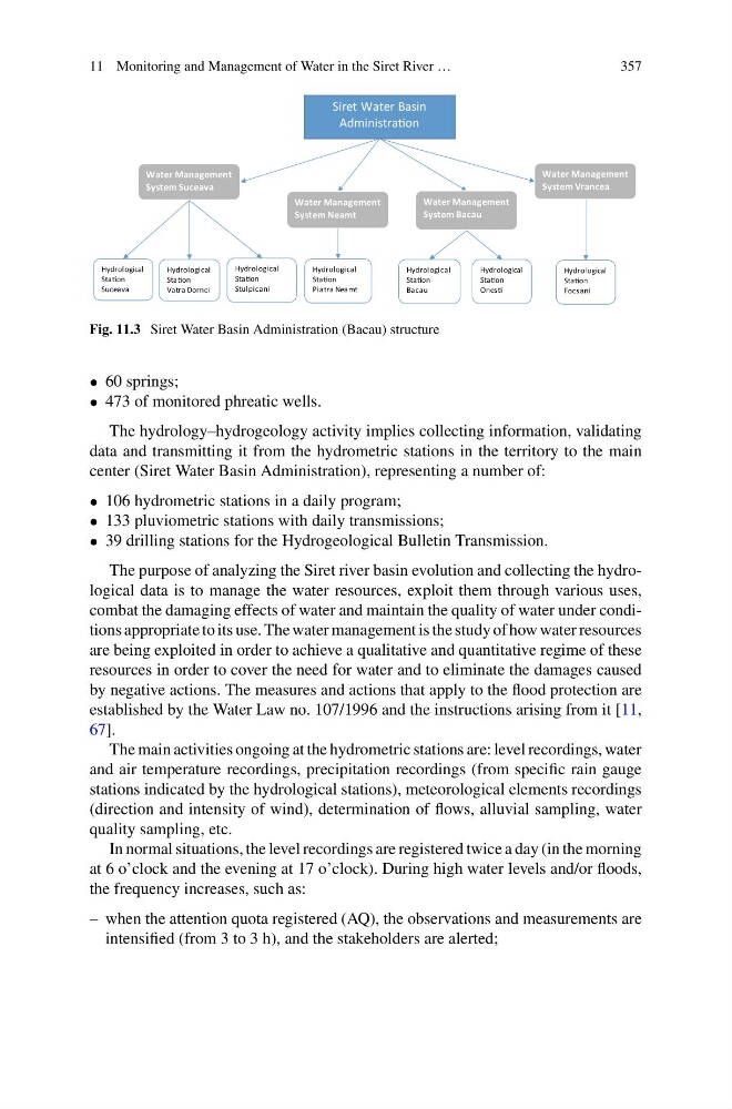
Fig. 11.3 Siret Water Basin Administration (Bacau) structure
• 60 springs;
• 473 of monitored phreatic wells.
The hydrology–hydrogeology activity implies collecting information, validating
data and transmitting it from the hydrometric stations in the territory to the main
center (Siret Water Basin Administration), representing a number of:
• 106 hydrometric stations in a daily program;
• 133 pluviometric stations with daily transmissions;
• 39 drilling stations for the Hydrogeological Bulletin Transmission.
The purpose of analyzing the Siret river basin evolution and collecting the hydrological data is to manage the water resources, exploit them through various uses,
combat the damaging effects of water and maintain the quality of water under conditions appropriate to its use. The water management is the study of how water resources
are being exploited in order to achieve a qualitative and quantitative regime of these
resources in order to cover the need for water and to eliminate the damages caused
by negative actions. The measures and actions that apply to the flood protection are
established by the Water Law no. 107/1996 and the instructions arising from it [11,
67].
The main activities ongoing at the hydrometric stations are: level recordings, water
and air temperature recordings, precipitation recordings (from specific rain gauge
stations indicated by the hydrological stations), meteorological elements recordings
(direction and intensity of wind), determination of flows, alluvial sampling, water
quality sampling, etc.
In normal situations, the level recordings are registered twice a day (in the morning
at 6 o’clock and the evening at 17 o’clock). During high water levels and/or floods,
the frequency increases, such as:
– when the attention quota registered (AQ), the observations and measurements are
intensified (from 3 to 3 h), and the stakeholders are alerted;
357
Siret Water Basin
AdministraƟon
Water Management
System Bacau
Water Management
System Suceava
Water Management
System Neamt
Water Management
System Vrancea
Hydrological
StaƟon
Suceava
Hydrological
StaƟon
Bacau
Hydrological
StaƟon
Vatra Dornei
Hydrological
StaƟon
Stulpicani
Hydrological
StaƟon
OnesƟ
Hydrological
StaƟon
Piatra Neamt
Hydrological
StaƟon
Focsani
Fig. 11.3 Siret Water Basin Administration (Bacau) structure
• 60 springs;
• 473 of monitored phreatic wells.
The hydrology–hydrogeology activity implies collecting information, validating
data and transmitting it from the hydrometric stations in the territory to the main
center (Siret Water Basin Administration), representing a number of:
• 106 hydrometric stations in a daily program;
• 133 pluviometric stations with daily transmissions;
• 39 drilling stations for the Hydrogeological Bulletin Transmission.
The purpose of analyzing the Siret river basin evolution and collecting the hydrological data is to manage the water resources, exploit them through various uses,
combat the damaging effects of water and maintain the quality of water under conditions appropriate to its use. The water management is the study of how water resources
are being exploited in order to achieve a qualitative and quantitative regime of these
resources in order to cover the need for water and to eliminate the damages caused
by negative actions. The measures and actions that apply to the flood protection are
established by the Water Law no. 107/1996 and the instructions arising from it [11,
67].
The main activities ongoing at the hydrometric stations are: level recordings, water
and air temperature recordings, precipitation recordings (from specific rain gauge
stations indicated by the hydrological stations), meteorological elements recordings
(direction and intensity of wind), determination of flows, alluvial sampling, water
quality sampling, etc.
In normal situations, the level recordings are registered twice a day (in the morning
at 6 o’clock and the evening at 17 o’clock). During high water levels and/or floods,
the frequency increases, such as:
– when the attention quota registered (AQ), the observations and measurements are
intensified (from 3 to 3 h), and the stakeholders are alerted;