

134
where 1 < j < i < n. If N indicates all combinations of record pairs for the complete
dataset, and the value of the slope is calculated as n = N (N − 1)/2 and β is considered to be the median of these n values.
Principal Component Analysis (PCA)
The algorithm for the calculation of the PCA can be described in a summarized
form using matrix algebra (Jolliffe and Cadima 2016), as a matrix with N rows as
intervals of time and n as points in the space. The matrix resultant will be N × n,
where i is the index time and j the space, in this case j represents each location with
information of precipitation. The value in any point in time and space is denoted
then by x ij . The purpose of the PCA is to find a coefficient matrix (E) that modifies
x by lineal operations to get a new group of variables Z. These new variables must
represent the majority of variance in terms of n points in the space, in a smallest
number possible, where p ≤ n
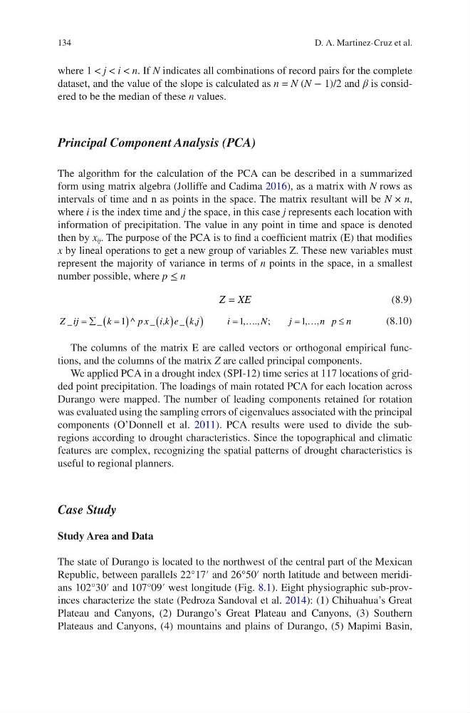
Z XE
=
(8.9)
Z ij
k
p x i k e k j
i
N
j
n p n
_
_
^
_
_
, ., ;
, ,
= å
=
( )
( ) ( )
= ¼
= ¼
£
1
1
1
,
,
(8.10)
The columns of the matrix E are called vectors or orthogonal empirical functions, and the columns of the matrix Z are called principal components.
We applied PCA in a drought index (SPI-12) time series at 117 locations of gridded point precipitation. The loadings of main rotated PCA for each location across
Durango were mapped. The number of leading components retained for rotation
was evaluated using the sampling errors of eigenvalues associated with the principal
components (O’Donnell et al. 2011). PCA results were used to divide the subregions according to drought characteristics. Since the topographical and climatic
features are complex, recognizing the spatial patterns of drought characteristics is
useful to regional planners.
Case Study
Study Area and Data
The state of Durango is located to the northwest of the central part of the Mexican
Republic, between parallels 22°17′ and 26°50′ north latitude and between meridians 102°30′ and 107°09′ west longitude (Fig. 8.1). Eight physiographic sub-provinces characterize the state (Pedroza Sandoval et al. 2014): (1) Chihuahua’s Great
Plateau and Canyons, (2) Durango’s Great Plateau and Canyons, (3) Southern
Plateaus and Canyons, (4) mountains and plains of Durango, (5) Mapimi Basin,
D. A. Martinez-Cruz et al.
where 1 < j < i < n. If N indicates all combinations of record pairs for the complete
dataset, and the value of the slope is calculated as n = N (N − 1)/2 and β is considered to be the median of these n values.
Principal Component Analysis (PCA)
The algorithm for the calculation of the PCA can be described in a summarized
form using matrix algebra (Jolliffe and Cadima 2016), as a matrix with N rows as
intervals of time and n as points in the space. The matrix resultant will be N × n,
where i is the index time and j the space, in this case j represents each location with
information of precipitation. The value in any point in time and space is denoted
then by x ij . The purpose of the PCA is to find a coefficient matrix (E) that modifies
x by lineal operations to get a new group of variables Z. These new variables must
represent the majority of variance in terms of n points in the space, in a smallest
number possible, where p ≤ n
Z XE
=
(8.9)
Z ij
k
p x i k e k j
i
N
j
n p n
_
_
^
_
_
, ., ;
, ,
= å
=
( )
( ) ( )
= ¼
= ¼
£
1
1
1
,
,
(8.10)
The columns of the matrix E are called vectors or orthogonal empirical functions, and the columns of the matrix Z are called principal components.
We applied PCA in a drought index (SPI-12) time series at 117 locations of gridded point precipitation. The loadings of main rotated PCA for each location across
Durango were mapped. The number of leading components retained for rotation
was evaluated using the sampling errors of eigenvalues associated with the principal
components (O’Donnell et al. 2011). PCA results were used to divide the subregions according to drought characteristics. Since the topographical and climatic
features are complex, recognizing the spatial patterns of drought characteristics is
useful to regional planners.
Case Study
Study Area and Data
The state of Durango is located to the northwest of the central part of the Mexican
Republic, between parallels 22°17′ and 26°50′ north latitude and between meridians 102°30′ and 107°09′ west longitude (Fig. 8.1). Eight physiographic sub-provinces characterize the state (Pedroza Sandoval et al. 2014): (1) Chihuahua’s Great
Plateau and Canyons, (2) Durango’s Great Plateau and Canyons, (3) Southern
Plateaus and Canyons, (4) mountains and plains of Durango, (5) Mapimi Basin,
D. A. Martinez-Cruz et al.