

448
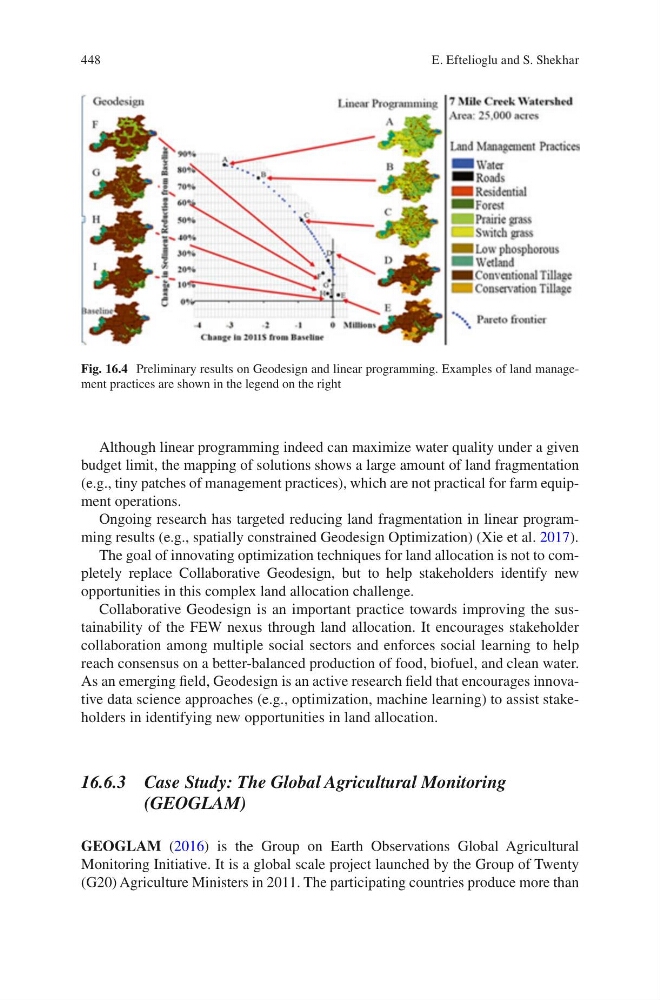
Although linear programming indeed can maximize water quality under a given
budget limit, the mapping of solutions shows a large amount of land fragmentation
(e.g., tiny patches of management practices), which are not practical for farm equipment operations.
Ongoing research has targeted reducing land fragmentation in linear programming results (e.g., spatially constrained Geodesign Optimization) (Xie et al. 2017).
The goal of innovating optimization techniques for land allocation is not to completely replace Collaborative Geodesign, but to help stakeholders identify new
opportunities in this complex land allocation challenge.
Collaborative Geodesign is an important practice towards improving the sustainability of the FEW nexus through land allocation. It encourages stakeholder
collaboration among multiple social sectors and enforces social learning to help
reach consensus on a better-balanced production of food, biofuel, and clean water.
As an emerging field, Geodesign is an active research field that encourages innovative data science approaches (e.g., optimization, machine learning) to assist stakeholders in identifying new opportunities in land allocation.
16.6.3 Case Study: The Global Agricultural Monitoring
(GEOGLAM)
GEOGLAM (2016) is the Group on Earth Observations Global Agricultural
Monitoring Initiative. It is a global scale project launched by the Group of Twenty
(G20) Agriculture Ministers in 2011. The participating countries produce more than
Fig. 16.4 Preliminary results on Geodesign and linear programming. Examples of land management practices are shown in the legend on the right
E. Eftelioglu and S. Shekhar
Although linear programming indeed can maximize water quality under a given
budget limit, the mapping of solutions shows a large amount of land fragmentation
(e.g., tiny patches of management practices), which are not practical for farm equipment operations.
Ongoing research has targeted reducing land fragmentation in linear programming results (e.g., spatially constrained Geodesign Optimization) (Xie et al. 2017).
The goal of innovating optimization techniques for land allocation is not to completely replace Collaborative Geodesign, but to help stakeholders identify new
opportunities in this complex land allocation challenge.
Collaborative Geodesign is an important practice towards improving the sustainability of the FEW nexus through land allocation. It encourages stakeholder
collaboration among multiple social sectors and enforces social learning to help
reach consensus on a better-balanced production of food, biofuel, and clean water.
As an emerging field, Geodesign is an active research field that encourages innovative data science approaches (e.g., optimization, machine learning) to assist stakeholders in identifying new opportunities in land allocation.
16.6.3 Case Study: The Global Agricultural Monitoring
(GEOGLAM)
GEOGLAM (2016) is the Group on Earth Observations Global Agricultural
Monitoring Initiative. It is a global scale project launched by the Group of Twenty
(G20) Agriculture Ministers in 2011. The participating countries produce more than
Fig. 16.4 Preliminary results on Geodesign and linear programming. Examples of land management practices are shown in the legend on the right
E. Eftelioglu and S. Shekhar