

the whole run-off and erosion processes and thus also the mosaic of vegetation cover
(Kidron and Yair 2008; Yair 2008). These are long-term processes and warrant longterm observations. They are, of course, totally dependent on the various human
impacts (former land use, grazing, collection, wood cutting, trampling, off-road
traffic) and thus the special sand dune area at Nizzana was very suitable for study
because it had been protected by the military. The contrast of the different land
use systems is seen in satellite images, where the Israeli–Egyptian border exhibits a
straight line of differing albedo. On the Egyptian side, the number of perennial
shrubs was reduced from about 400 per km
2 (in 1945) to about 100 (in 1989),
whereas on the Israeli side, with fluctuations, it increased to more than 600, making
the sand dune area spotty green (Tsoar 2008). Another contrasting pattern is given by
the steep gradient of aridity from south to north, from about 100 mm to less than
50 mm within a 50 km distance, but local rainfalls are very irregular. These sand
dune mosaics are different in the north, where dune movements of the dune crests are
lacking, in contrast to the south where more specially adapted sand dune plants are
found. Many experiments could be performed to see the effects and recovery, as well
as intensive measurements of the main parameters of desert plant life (Breckle et al.
2008), including root growth, by regular checking of rhizotron tubes around dwarf
shrubs (Fig. 22c). Small television cameras provided pictures, which were processed
by automatic image analysis (Jankowski et al. 1995; Breckle et al. 2001c; Erz
et al. 2005).
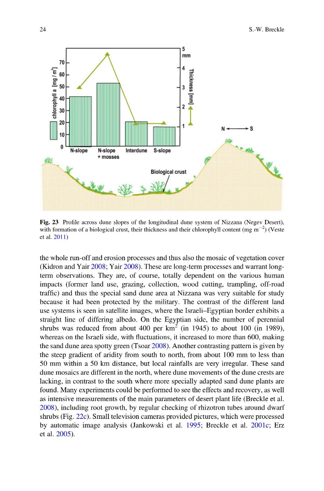
Fig. 23 Profile across dune slopes of the longitudinal dune system of Nizzana (Negev Desert),
with formation of a biological crust, their thickness and their chlorophyll content (mg m
À2
) (Veste
et al. 2011)
24
S.-W. Breckle
(Kidron and Yair 2008; Yair 2008). These are long-term processes and warrant longterm observations. They are, of course, totally dependent on the various human
impacts (former land use, grazing, collection, wood cutting, trampling, off-road
traffic) and thus the special sand dune area at Nizzana was very suitable for study
because it had been protected by the military. The contrast of the different land
use systems is seen in satellite images, where the Israeli–Egyptian border exhibits a
straight line of differing albedo. On the Egyptian side, the number of perennial
shrubs was reduced from about 400 per km
2 (in 1945) to about 100 (in 1989),
whereas on the Israeli side, with fluctuations, it increased to more than 600, making
the sand dune area spotty green (Tsoar 2008). Another contrasting pattern is given by
the steep gradient of aridity from south to north, from about 100 mm to less than
50 mm within a 50 km distance, but local rainfalls are very irregular. These sand
dune mosaics are different in the north, where dune movements of the dune crests are
lacking, in contrast to the south where more specially adapted sand dune plants are
found. Many experiments could be performed to see the effects and recovery, as well
as intensive measurements of the main parameters of desert plant life (Breckle et al.
2008), including root growth, by regular checking of rhizotron tubes around dwarf
shrubs (Fig. 22c). Small television cameras provided pictures, which were processed
by automatic image analysis (Jankowski et al. 1995; Breckle et al. 2001c; Erz
et al. 2005).
Fig. 23 Profile across dune slopes of the longitudinal dune system of Nizzana (Negev Desert),
with formation of a biological crust, their thickness and their chlorophyll content (mg m
À2
) (Veste
et al. 2011)
24
S.-W. Breckle