

223
matter, accompanied by a significant impoverishment of their microbial flora. As a
result, a severe process of soil compaction is triggered (Albanesi et al. 2001; Baridón
and Casas 2014; Rojas et al. 2016). These combined factors, not only decrease fertility but also infiltration capacity and water retention of soils (Magliano et al. 2017).
Therefore, small decreases in rainfall lead to increasing yield losses and, in dry
years, to the loss of the harvest. On the other hand, the decrease in the infiltration
capacity of the soil increases the runoff. Given that the rains in the summer period
are usually torrential in this region, in slightly undulating areas such as those in the
northeast of the Province of Santiago del Estero and southwest of the Province of
Chaco, water erosion processes of increasing magnitude are triggered.
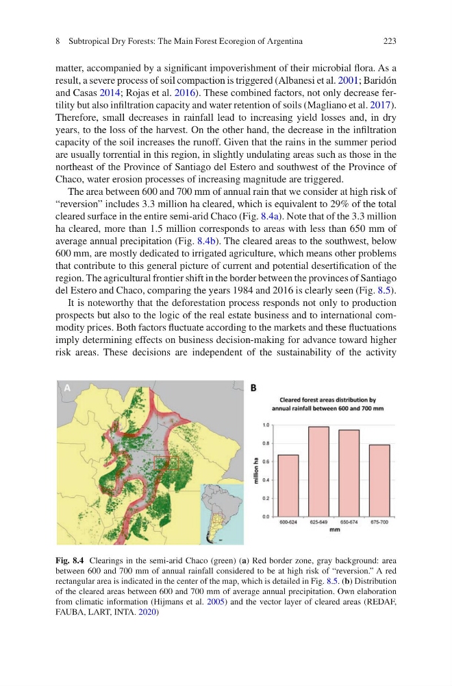
The area between 600 and 700 mm of annual rain that we consider at high risk of
“reversion” includes 3.3 million ha cleared, which is equivalent to 29% of the total
cleared surface in the entire semi-arid Chaco (Fig. 8.4a). Note that of the 3.3 million
ha cleared, more than 1.5 million corresponds to areas with less than 650 mm of
average annual precipitation (Fig. 8.4b). The cleared areas to the southwest, below
600 mm, are mostly dedicated to irrigated agriculture, which means other problems
that contribute to this general picture of current and potential desertification of the
region. The agricultural frontier shift in the border between the provinces of Santiago
del Estero and Chaco, comparing the years 1984 and 2016 is clearly seen (Fig. 8.5).
It is noteworthy that the deforestation process responds not only to production
prospects but also to the logic of the real estate business and to international commodity prices. Both factors fluctuate according to the markets and these fluctuations
imply determining effects on business decision-making for advance toward higher
risk areas. These decisions are independent of the sustainability of the activity
Fig. 8.4 Clearings in the semi-arid Chaco (green) (a) Red border zone, gray background: area
between 600 and 700 mm of annual rainfall considered to be at high risk of “reversion.” A red
rectangular area is indicated in the center of the map, which is detailed in Fig. 8.5. (b) Distribution
of the cleared areas between 600 and 700 mm of average annual precipitation. Own elaboration
from climatic information (Hijmans et al. 2005) and the vector layer of cleared areas (REDAF,
FAUBA, LART, INTA. 2020)
8 Subtropical Dry Forests: The Main Forest Ecoregion of Argentina
matter, accompanied by a significant impoverishment of their microbial flora. As a
result, a severe process of soil compaction is triggered (Albanesi et al. 2001; Baridón
and Casas 2014; Rojas et al. 2016). These combined factors, not only decrease fertility but also infiltration capacity and water retention of soils (Magliano et al. 2017).
Therefore, small decreases in rainfall lead to increasing yield losses and, in dry
years, to the loss of the harvest. On the other hand, the decrease in the infiltration
capacity of the soil increases the runoff. Given that the rains in the summer period
are usually torrential in this region, in slightly undulating areas such as those in the
northeast of the Province of Santiago del Estero and southwest of the Province of
Chaco, water erosion processes of increasing magnitude are triggered.
The area between 600 and 700 mm of annual rain that we consider at high risk of
“reversion” includes 3.3 million ha cleared, which is equivalent to 29% of the total
cleared surface in the entire semi-arid Chaco (Fig. 8.4a). Note that of the 3.3 million
ha cleared, more than 1.5 million corresponds to areas with less than 650 mm of
average annual precipitation (Fig. 8.4b). The cleared areas to the southwest, below
600 mm, are mostly dedicated to irrigated agriculture, which means other problems
that contribute to this general picture of current and potential desertification of the
region. The agricultural frontier shift in the border between the provinces of Santiago
del Estero and Chaco, comparing the years 1984 and 2016 is clearly seen (Fig. 8.5).
It is noteworthy that the deforestation process responds not only to production
prospects but also to the logic of the real estate business and to international commodity prices. Both factors fluctuate according to the markets and these fluctuations
imply determining effects on business decision-making for advance toward higher
risk areas. These decisions are independent of the sustainability of the activity
Fig. 8.4 Clearings in the semi-arid Chaco (green) (a) Red border zone, gray background: area
between 600 and 700 mm of annual rainfall considered to be at high risk of “reversion.” A red
rectangular area is indicated in the center of the map, which is detailed in Fig. 8.5. (b) Distribution
of the cleared areas between 600 and 700 mm of average annual precipitation. Own elaboration
from climatic information (Hijmans et al. 2005) and the vector layer of cleared areas (REDAF,
FAUBA, LART, INTA. 2020)
8 Subtropical Dry Forests: The Main Forest Ecoregion of Argentina