

13.4 Potential Usage of Spatial Database
Turkey has recently entered a period in which yield is improved by using innovative
applications in every field of agriculture. Having a spatial database allows the
opportunity to create more precise statistics. Therefore, Turkey uses its spatial
infrastructure for the maintenance of an agricultural inventory (Fig. 13.13). A special
software procured by MoFAL is used in this study. The software has the capacity of
GIS integration (Erden and Koçak 2015).
Besides, the spatial database of MoFAL is used for farm-level microanalysis,
including the financial, demographic, and physical inferences.
All European Union countries are part of the Farmers Agricultural Data Network
(FADN), and they have national databases of individual farm accounts. For this
reason, in Turkey, MoFAL provides geospatial and geostatistical data services
regarding FADN requirements. Parcel polygons of a selected farm are shown in
Fig. 13.14. This screen enables different kinds of filters including date, region,
province, etc. and analysis options. FADN based reports also include accumulated
distribution analysis of selected parameters such as income as seen in Fig. 13.15.
Another example is land use-type distribution (perennial plant, crop field, vegetable
garden, etc.) report (Fig. 13.16) that is generated concerning chosen geographical
region or province, date interval, and the land ownership type (rental land, ownedland, shared land, operated land, etc.).
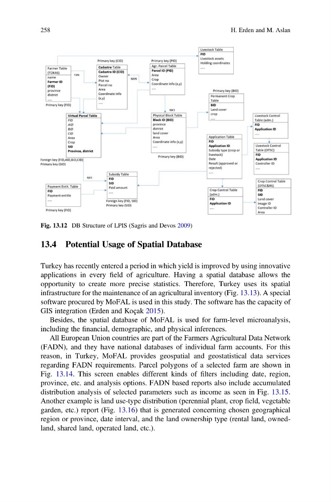
Fig. 13.12 DB Structure of LPIS (Sagris and Devos 2009)
258
H. Erden and M. Aslan
Turkey has recently entered a period in which yield is improved by using innovative
applications in every field of agriculture. Having a spatial database allows the
opportunity to create more precise statistics. Therefore, Turkey uses its spatial
infrastructure for the maintenance of an agricultural inventory (Fig. 13.13). A special
software procured by MoFAL is used in this study. The software has the capacity of
GIS integration (Erden and Koçak 2015).
Besides, the spatial database of MoFAL is used for farm-level microanalysis,
including the financial, demographic, and physical inferences.
All European Union countries are part of the Farmers Agricultural Data Network
(FADN), and they have national databases of individual farm accounts. For this
reason, in Turkey, MoFAL provides geospatial and geostatistical data services
regarding FADN requirements. Parcel polygons of a selected farm are shown in
Fig. 13.14. This screen enables different kinds of filters including date, region,
province, etc. and analysis options. FADN based reports also include accumulated
distribution analysis of selected parameters such as income as seen in Fig. 13.15.
Another example is land use-type distribution (perennial plant, crop field, vegetable
garden, etc.) report (Fig. 13.16) that is generated concerning chosen geographical
region or province, date interval, and the land ownership type (rental land, ownedland, shared land, operated land, etc.).
Fig. 13.12 DB Structure of LPIS (Sagris and Devos 2009)
258
H. Erden and M. Aslan