

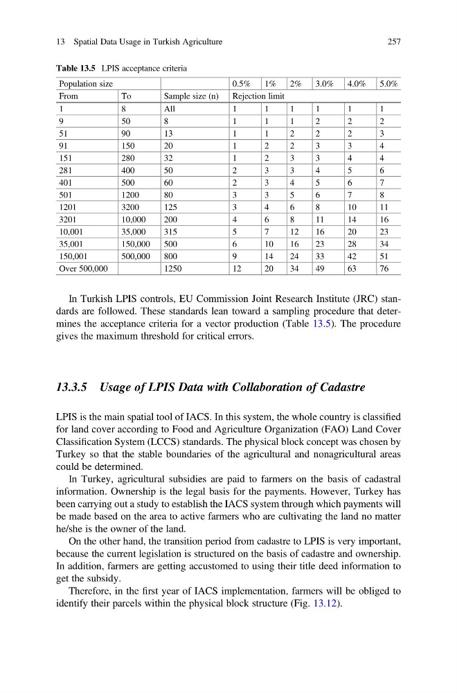
In Turkish LPIS controls, EU Commission Joint Research Institute (JRC) standards are followed. These standards lean toward a sampling procedure that determines the acceptance criteria for a vector production (Table 13.5). The procedure
gives the maximum threshold for critical errors.
13.3.5 Usage of LPIS Data with Collaboration of Cadastre
LPIS is the main spatial tool of IACS. In this system, the whole country is classified
for land cover according to Food and Agriculture Organization (FAO) Land Cover
Classification System (LCCS) standards. The physical block concept was chosen by
Turkey so that the stable boundaries of the agricultural and nonagricultural areas
could be determined.
In Turkey, agricultural subsidies are paid to farmers on the basis of cadastral
information. Ownership is the legal basis for the payments. However, Turkey has
been carrying out a study to establish the IACS system through which payments will
be made based on the area to active farmers who are cultivating the land no matter
he/she is the owner of the land.
On the other hand, the transition period from cadastre to LPIS is very important,
because the current legislation is structured on the basis of cadastre and ownership.
In addition, farmers are getting accustomed to using their title deed information to
get the subsidy.
Therefore, in the first year of IACS implementation, farmers will be obliged to
identify their parcels within the physical block structure (Fig. 13.12).
Table 13.5 LPIS acceptance criteria
Population size
0.5%
1%
2%
3.0%
4.0%
5.0%
From
To
Sample size (n)
Rejection limit
1
8
All
1
1
1
1
1
1
9
5 0
8
1
1
1
2
2
2
51
90
13
1
1
2
2
2
3
91
150
20
1
2
2
3
3
4
151
280
32
1
2
3
3
4
4
281
400
50
2
3
3
4
5
6
401
500
60
2
3
4
5
6
7
501
1200
80
3
3
5
6
7
8
1201
3200
125
3
4
6
8
10
11
3201
10,000
200
4
6
8
11
14
16
10,001
35,000
315
5
7
12
16
20
23
35,001
150,000
500
6
10
16
23
28
34
150,001
500,000
800
9
14
24
33
42
51
Over 500,000
1250
12
20
34
49
63
76
13 Spatial Data Usage in Turkish Agriculture
257
gives the maximum threshold for critical errors.
13.3.5 Usage of LPIS Data with Collaboration of Cadastre
LPIS is the main spatial tool of IACS. In this system, the whole country is classified
for land cover according to Food and Agriculture Organization (FAO) Land Cover
Classification System (LCCS) standards. The physical block concept was chosen by
Turkey so that the stable boundaries of the agricultural and nonagricultural areas
could be determined.
In Turkey, agricultural subsidies are paid to farmers on the basis of cadastral
information. Ownership is the legal basis for the payments. However, Turkey has
been carrying out a study to establish the IACS system through which payments will
be made based on the area to active farmers who are cultivating the land no matter
he/she is the owner of the land.
On the other hand, the transition period from cadastre to LPIS is very important,
because the current legislation is structured on the basis of cadastre and ownership.
In addition, farmers are getting accustomed to using their title deed information to
get the subsidy.
Therefore, in the first year of IACS implementation, farmers will be obliged to
identify their parcels within the physical block structure (Fig. 13.12).
Table 13.5 LPIS acceptance criteria
Population size
0.5%
1%
2%
3.0%
4.0%
5.0%
From
To
Sample size (n)
Rejection limit
1
8
All
1
1
1
1
1
1
9
5 0
8
1
1
1
2
2
2
51
90
13
1
1
2
2
2
3
91
150
20
1
2
2
3
3
4
151
280
32
1
2
3
3
4
4
281
400
50
2
3
3
4
5
6
401
500
60
2
3
4
5
6
7
501
1200
80
3
3
5
6
7
8
1201
3200
125
3
4
6
8
10
11
3201
10,000
200
4
6
8
11
14
16
10,001
35,000
315
5
7
12
16
20
23
35,001
150,000
500
6
10
16
23
28
34
150,001
500,000
800
9
14
24
33
42
51
Over 500,000
1250
12
20
34
49
63
76
13 Spatial Data Usage in Turkish Agriculture
257