

Conclusions
One hundred thirty-eight studies from the literature
reporting remote sensing data, GIS methods, materials
and indices used worldwide to estimate the shoreline
evolution, have been analyzed. Our aim was to define
the usage of such techniques and methods and finally
through the meta-analysis to highlight the most dominant indicators, software and methods followed by
researchers the last 20-years relative to the coastal erosion/accretion subject. Furthermore this review targets to
emerged some critical points through studied literature
such as a) the low rate of high-resolution satellite images
usage in a subject where the accuracy is prerequisite b) the
necessity of the Landsat images being improved as they
are the only ones related to the distant past and freely
available, c) the usage of the new generation of UAV’s
since 2015 as an alternative low-cost source for very high
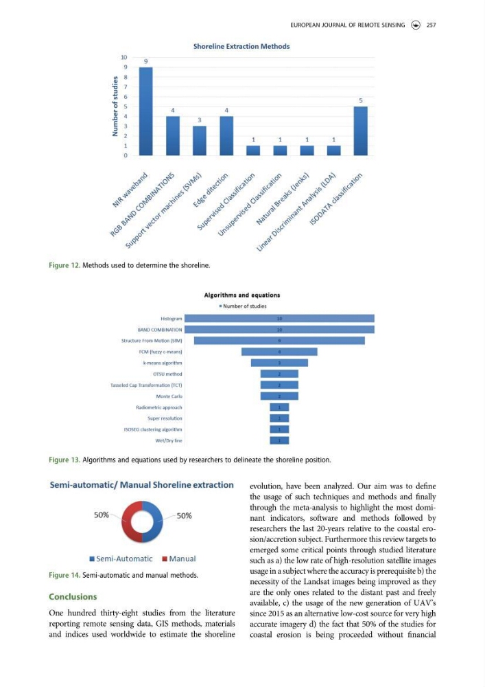
accurate imagery d) the fact that 50% of the studies for
coastal erosion is being proceeded without financial
Figure 13. Algorithms and equations used by researchers to delineate the shoreline position.
Figure 12. Methods used to determine the shoreline.
Figure 14. Semi-automatic and manual methods.
EUROPEAN JOURNAL OF REMOTE SENSING
257
One hundred thirty-eight studies from the literature
reporting remote sensing data, GIS methods, materials
and indices used worldwide to estimate the shoreline
evolution, have been analyzed. Our aim was to define
the usage of such techniques and methods and finally
through the meta-analysis to highlight the most dominant indicators, software and methods followed by
researchers the last 20-years relative to the coastal erosion/accretion subject. Furthermore this review targets to
emerged some critical points through studied literature
such as a) the low rate of high-resolution satellite images
usage in a subject where the accuracy is prerequisite b) the
necessity of the Landsat images being improved as they
are the only ones related to the distant past and freely
available, c) the usage of the new generation of UAV’s
since 2015 as an alternative low-cost source for very high
accurate imagery d) the fact that 50% of the studies for
coastal erosion is being proceeded without financial
Figure 13. Algorithms and equations used by researchers to delineate the shoreline position.
Figure 12. Methods used to determine the shoreline.
Figure 14. Semi-automatic and manual methods.
EUROPEAN JOURNAL OF REMOTE SENSING
257