

depended on many factors (i.e. available data, equipment,
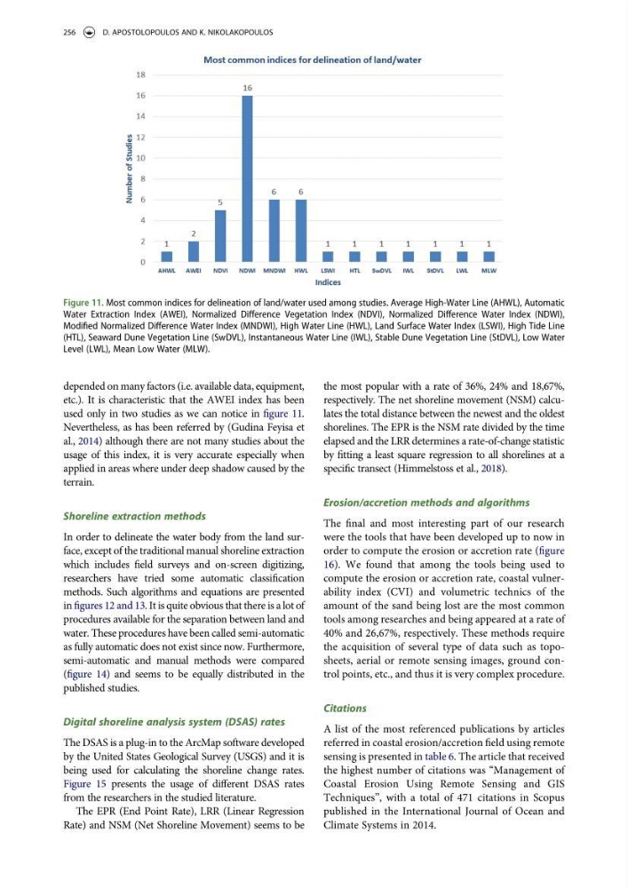
etc.). It is characteristic that the AWEI index has been
used only in two studies as we can notice in figure 11.
Nevertheless, as has been referred by (Gudina Feyisa et
al., 2014) although there are not many studies about the
usage of this index, it is very accurate especially when
applied in areas where under deep shadow caused by the
terrain.
Shoreline extraction methods
In order to delineate the water body from the land surface, except of the traditional manual shoreline extraction
which includes field surveys and on-screen digitizing,
researchers have tried some automatic classification
methods. Such algorithms and equations are presented
in figures 12 and 13. It is quite obvious that there is a lot of
procedures available for the separation between land and
water. These procedures have been called semi-automatic
as fully automatic does not exist since now. Furthermore,
semi-automatic and manual methods were compared
(figure 14) and seems to be equally distributed in the
published studies.
Digital shoreline analysis system (DSAS) rates
The DSAS is a plug-in to the ArcMap software developed
by the United States Geological Survey (USGS) and it is
being used for calculating the shoreline change rates.
Figure 15 presents the usage of different DSAS rates
from the researchers in the studied literature.
The EPR (End Point Rate), LRR (Linear Regression
Rate) and NSM (Net Shoreline Movement) seems to be
the most popular with a rate of 36%, 24% and 18,67%,
respectively. The net shoreline movement (NSM) calculates the total distance between the newest and the oldest
shorelines. The EPR is the NSM rate divided by the time
elapsed and the LRR determines a rate-of-change statistic
by fitting a least square regression to all shorelines at a
specific transect (Himmelstoss et al., 2018).
Erosion/accretion methods and algorithms
The final and most interesting part of our research
were the tools that have been developed up to now in
order to compute the erosion or accretion rate (figure
16). We found that among the tools being used to
compute the erosion or accretion rate, coastal vulnerability index (CVI) and volumetric technics of the
amount of the sand being lost are the most common
tools among researches and being appeared at a rate of
40% and 26,67%, respectively. These methods require
the acquisition of several type of data such as toposheets, aerial or remote sensing images, ground control points, etc., and thus it is very complex procedure.
Citations
A list of the most referenced publications by articles
referred in coastal erosion/accretion field using remote
sensing is presented in table 6. The article that received
the highest number of citations was “Management of
Coastal Erosion Using Remote Sensing and GIS
Techniques”, with a total of 471 citations in Scopus
published in the International Journal of Ocean and
Climate Systems in 2014.
Figure 11. Most common indices for delineation of land/water used among studies. Average High-Water Line (AHWL), Automatic
Water Extraction Index (AWEI), Normalized Difference Vegetation Index (NDVI), Normalized Difference Water Index (NDWI),
Modified Normalized Difference Water Index (MNDWI), High Water Line (HWL), Land Surface Water Index (LSWI), High Tide Line
(HTL), Seaward Dune Vegetation Line (SwDVL), Instantaneous Water Line (IWL), Stable Dune Vegetation Line (StDVL), Low Water
Level (LWL), Mean Low Water (MLW).
256
D. APOSTOLOPOULOS AND K. NIKOLAKOPOULOS
etc.). It is characteristic that the AWEI index has been
used only in two studies as we can notice in figure 11.
Nevertheless, as has been referred by (Gudina Feyisa et
al., 2014) although there are not many studies about the
usage of this index, it is very accurate especially when
applied in areas where under deep shadow caused by the
terrain.
Shoreline extraction methods
In order to delineate the water body from the land surface, except of the traditional manual shoreline extraction
which includes field surveys and on-screen digitizing,
researchers have tried some automatic classification
methods. Such algorithms and equations are presented
in figures 12 and 13. It is quite obvious that there is a lot of
procedures available for the separation between land and
water. These procedures have been called semi-automatic
as fully automatic does not exist since now. Furthermore,
semi-automatic and manual methods were compared
(figure 14) and seems to be equally distributed in the
published studies.
Digital shoreline analysis system (DSAS) rates
The DSAS is a plug-in to the ArcMap software developed
by the United States Geological Survey (USGS) and it is
being used for calculating the shoreline change rates.
Figure 15 presents the usage of different DSAS rates
from the researchers in the studied literature.
The EPR (End Point Rate), LRR (Linear Regression
Rate) and NSM (Net Shoreline Movement) seems to be
the most popular with a rate of 36%, 24% and 18,67%,
respectively. The net shoreline movement (NSM) calculates the total distance between the newest and the oldest
shorelines. The EPR is the NSM rate divided by the time
elapsed and the LRR determines a rate-of-change statistic
by fitting a least square regression to all shorelines at a
specific transect (Himmelstoss et al., 2018).
Erosion/accretion methods and algorithms
The final and most interesting part of our research
were the tools that have been developed up to now in
order to compute the erosion or accretion rate (figure
16). We found that among the tools being used to
compute the erosion or accretion rate, coastal vulnerability index (CVI) and volumetric technics of the
amount of the sand being lost are the most common
tools among researches and being appeared at a rate of
40% and 26,67%, respectively. These methods require
the acquisition of several type of data such as toposheets, aerial or remote sensing images, ground control points, etc., and thus it is very complex procedure.
Citations
A list of the most referenced publications by articles
referred in coastal erosion/accretion field using remote
sensing is presented in table 6. The article that received
the highest number of citations was “Management of
Coastal Erosion Using Remote Sensing and GIS
Techniques”, with a total of 471 citations in Scopus
published in the International Journal of Ocean and
Climate Systems in 2014.
Figure 11. Most common indices for delineation of land/water used among studies. Average High-Water Line (AHWL), Automatic
Water Extraction Index (AWEI), Normalized Difference Vegetation Index (NDVI), Normalized Difference Water Index (NDWI),
Modified Normalized Difference Water Index (MNDWI), High Water Line (HWL), Land Surface Water Index (LSWI), High Tide Line
(HTL), Seaward Dune Vegetation Line (SwDVL), Instantaneous Water Line (IWL), Stable Dune Vegetation Line (StDVL), Low Water
Level (LWL), Mean Low Water (MLW).
256
D. APOSTOLOPOULOS AND K. NIKOLAKOPOULOS