

4. Coastal Erosion and Protection Measures Including Case Studies
125
As on 141)9/04
-------------- As on 13/08A4
-------------- As on 25/08/04
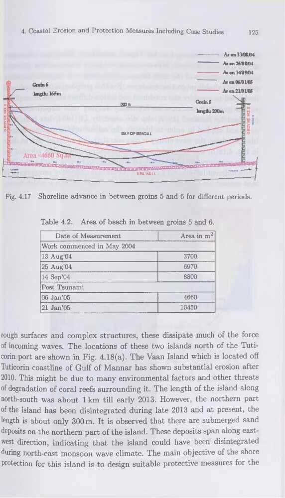
Fig. 4.17 Shoreline advance in between groins 5 and 6 for different periods.
Table 4.2. Area of beach in between groins 5 and 6.
Date of Measurement
Area in m2
Work commenced in May 2004
13 Aug’04
3700
25 Aug’04
6970
14 Sep’04
8800
Post Tsunami
06 Jan’05
4660
21 Jan’05
10450
rough surfaces and complex structures, these dissipate much of the force
of incoming waves. The locations of these two islands north of the Tuticorin port are shown in Fig. 4.18(a). The Vaan Island which is located off
Tuticorin coastline of Gulf of Mannar has shown substantial érosion after
2010. This might be due to many environmental factors and other threats
of dégradation of cor al reefs surrounding it. The length of the island along
north-south was about 1 km till early 2013. However, the northern part
of the island has been disintegrated during late 2013 and at présent, the
length is about only 300 m. It is observed that there are submerged sand
deposits on the northern part of the island. These deposits span along eastwest direction, indicating that the island could hâve been disintegrated
during north-east monsoon wave climate. The main objective of the shore
protection for this island is to design suitable protective measures for the
125
As on 141)9/04
-------------- As on 13/08A4
-------------- As on 25/08/04
Fig. 4.17 Shoreline advance in between groins 5 and 6 for different periods.
Table 4.2. Area of beach in between groins 5 and 6.
Date of Measurement
Area in m2
Work commenced in May 2004
13 Aug’04
3700
25 Aug’04
6970
14 Sep’04
8800
Post Tsunami
06 Jan’05
4660
21 Jan’05
10450
rough surfaces and complex structures, these dissipate much of the force
of incoming waves. The locations of these two islands north of the Tuticorin port are shown in Fig. 4.18(a). The Vaan Island which is located off
Tuticorin coastline of Gulf of Mannar has shown substantial érosion after
2010. This might be due to many environmental factors and other threats
of dégradation of cor al reefs surrounding it. The length of the island along
north-south was about 1 km till early 2013. However, the northern part
of the island has been disintegrated during late 2013 and at présent, the
length is about only 300 m. It is observed that there are submerged sand
deposits on the northern part of the island. These deposits span along eastwest direction, indicating that the island could hâve been disintegrated
during north-east monsoon wave climate. The main objective of the shore
protection for this island is to design suitable protective measures for the