

The Large-Scale Thermohaline Structure of the Ross Gyre
87
34.6
34.65
34.7
34.75
Salinity
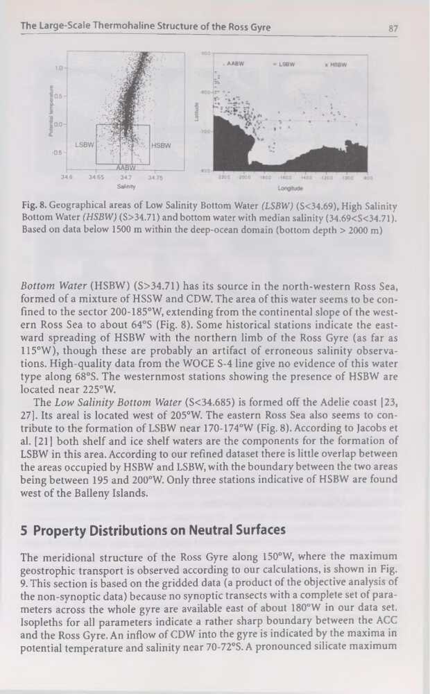
Fig. 8. Geographical areas of Low Salinity Bottom Water (LSBW) (S<34.69), High Salinity
Bottom Water (HSBW) (S>34.71) and bottom water with médian salinity (34.69
Bottom Water (HSBW) (S>34.71) has its source in the north-western Ross Sea,
formed of a mixture of HSSW and CDW. The area of this water seems to be confined to the sector 200-185°W, extending from the continental slope of the western Ross Sea to about 64°S (Fig. 8). Some historical stations indicate the eastward spreading of HSBW with the northern limb of the Ross Gyre (as far as
115°W), though these are probably an artifact of erroneous salinity observations. High-quality data from the WOCE S-4 line give no evidence of this water
type along 68°S. The westernmost stations showing the presence of HSBW are
located near 225°W.
The Low Salinity Bottom Water (S<34.685) is formed off the Adelie coast [23,
27]. Its areal is located west of 205°W. The eastern Ross Sea also seems to contribute to the formation of LSBW near 170-174°W (Fig. 8). According to Jacobs et
al. [21] both shelf and ice shelf waters are the components for the formation of
LSBW in this area. According to our refined dataset there is little overlap between
the areas occupied by HSBW and LSBW, with the boundary between the two areas
being between 195 and 200°W. Only three stations indicative of HSBW are found
west of the Balleny Islands.
5 Property Distributions on Neutral Surfaces
The méridional structure of the Ross Gyre along 150°W, where the maximum
geostrophic transport is observed according to our calculations, is shown in Fig.
9. This section is based on the gridded data (a product of the objective analysis of
the non-synoptic data) because no synoptic transects with a complété set of parameters across the whole gyre are available east of about 180°W in our data set.
Isopleths for ail parameters indicate a rather sharp boundary between the ACC
and the Ross Gyre. An inflow of CDW into the gyre is indicated by the maxima in
potential température and salinity near 70-72°S. A pronounced silicate maximum
87
34.6
34.65
34.7
34.75
Salinity
Fig. 8. Geographical areas of Low Salinity Bottom Water (LSBW) (S<34.69), High Salinity
Bottom Water (HSBW) (S>34.71) and bottom water with médian salinity (34.69
Bottom Water (HSBW) (S>34.71) has its source in the north-western Ross Sea,
formed of a mixture of HSSW and CDW. The area of this water seems to be confined to the sector 200-185°W, extending from the continental slope of the western Ross Sea to about 64°S (Fig. 8). Some historical stations indicate the eastward spreading of HSBW with the northern limb of the Ross Gyre (as far as
115°W), though these are probably an artifact of erroneous salinity observations. High-quality data from the WOCE S-4 line give no evidence of this water
type along 68°S. The westernmost stations showing the presence of HSBW are
located near 225°W.
The Low Salinity Bottom Water (S<34.685) is formed off the Adelie coast [23,
27]. Its areal is located west of 205°W. The eastern Ross Sea also seems to contribute to the formation of LSBW near 170-174°W (Fig. 8). According to Jacobs et
al. [21] both shelf and ice shelf waters are the components for the formation of
LSBW in this area. According to our refined dataset there is little overlap between
the areas occupied by HSBW and LSBW, with the boundary between the two areas
being between 195 and 200°W. Only three stations indicative of HSBW are found
west of the Balleny Islands.
5 Property Distributions on Neutral Surfaces
The méridional structure of the Ross Gyre along 150°W, where the maximum
geostrophic transport is observed according to our calculations, is shown in Fig.
9. This section is based on the gridded data (a product of the objective analysis of
the non-synoptic data) because no synoptic transects with a complété set of parameters across the whole gyre are available east of about 180°W in our data set.
Isopleths for ail parameters indicate a rather sharp boundary between the ACC
and the Ross Gyre. An inflow of CDW into the gyre is indicated by the maxima in
potential température and salinity near 70-72°S. A pronounced silicate maximum