

Temporal Variability of Currents in the Ross Sea (Antarctica)
105
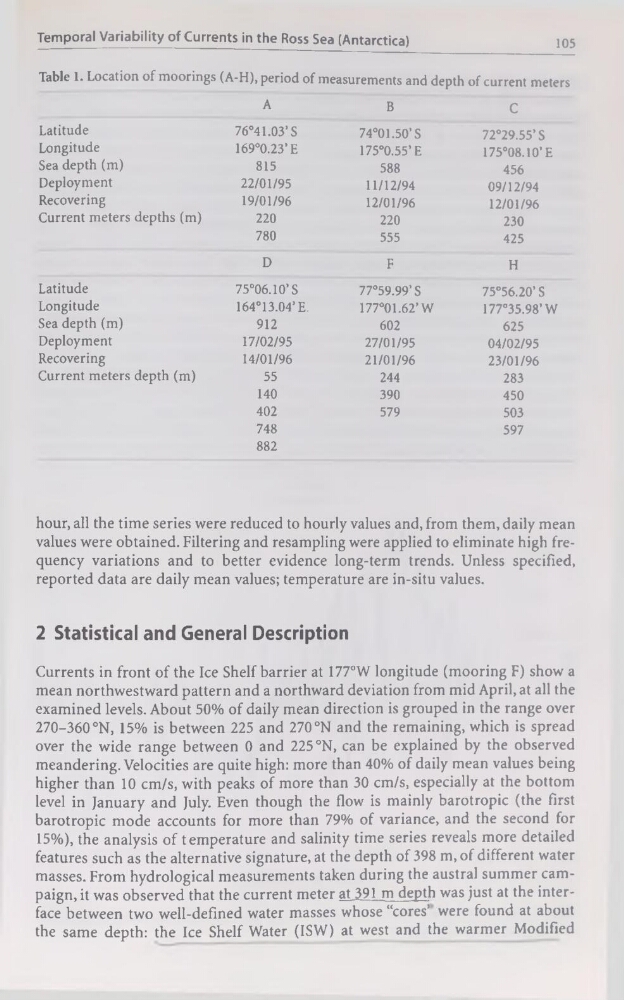
Table 1. Location of moorings (A-H), period of measurements and depth of current meters
A
B
C
Latitude
76°41.03’S
74°01.50’S
72°29.55’S
Longitude
169°0.23’E
175°0.55’E
175°08.10’E
Sea depth (m)
815
588
456
Deployment
22/01/95
11/12/94
09/12/94
Recovering
19/01/96
12/01/96
12/01/96
Current meters depths (m)
220
220
230
780
555
425
D
F
H
Latitude
75°06.10’S
77°59.99’ S
75°56.20’ S
Longitude
164°13.04’E.
177°01.62’W
177°35.98’W
Sea depth (m)
912
602
625
Deployment
17/02/95
27/01/95
04/02/95
Recovering
14/01/96
21/01/96
23/01/96
Current meters depth (m)
55
244
283
140
390
450
402
579
503
748
597
882
hour, ail the time sériés were reduced to hourly values and, from them, daily mean
values were obtained. Filtering and resampling were applied to eliminate high frequency variations and to better evidence long-term trends. Unless specified,
reported data are daily mean values; température are in-situ values.
2 Statistical and General Description
Currents in front of the Ice Shelf barrier at 177°W longitude (mooring F) show a
mean northwestward pattern and a northward déviation from mid April.at ail the
examined levels. About 50% of daily mean direction is grouped in the range over
270-360°N, 15% is between 225 and 270 °N and the remaining, which is spread
over the wide range between 0 and 225 °N, can be explained by the observed
meandering. Velocities are quite high: more than 40% of daily mean values being
higher than 10 cm/s, with peaks of more than 30 cm/s, especially at the bottom
level in January and July. Even though the flow is mainly barotropic (the first
barotropic mode accounts for more than 79% of variance, and the second for
15%), the analysis of température and salinity time sériés reveals more detailed
features such as the alternative signature, at the depth of 398 m, of different water
masses. From hydrological measurements taken during the austral summer campaign, it was observed that the current meter at391 m depth was just at the interface between two well-defined water masses whose “cores’ were found at about
the same depth: the Ice Shelf Water (ISW) at west and the warmer Modified
105
Table 1. Location of moorings (A-H), period of measurements and depth of current meters
A
B
C
Latitude
76°41.03’S
74°01.50’S
72°29.55’S
Longitude
169°0.23’E
175°0.55’E
175°08.10’E
Sea depth (m)
815
588
456
Deployment
22/01/95
11/12/94
09/12/94
Recovering
19/01/96
12/01/96
12/01/96
Current meters depths (m)
220
220
230
780
555
425
D
F
H
Latitude
75°06.10’S
77°59.99’ S
75°56.20’ S
Longitude
164°13.04’E.
177°01.62’W
177°35.98’W
Sea depth (m)
912
602
625
Deployment
17/02/95
27/01/95
04/02/95
Recovering
14/01/96
21/01/96
23/01/96
Current meters depth (m)
55
244
283
140
390
450
402
579
503
748
597
882
hour, ail the time sériés were reduced to hourly values and, from them, daily mean
values were obtained. Filtering and resampling were applied to eliminate high frequency variations and to better evidence long-term trends. Unless specified,
reported data are daily mean values; température are in-situ values.
2 Statistical and General Description
Currents in front of the Ice Shelf barrier at 177°W longitude (mooring F) show a
mean northwestward pattern and a northward déviation from mid April.at ail the
examined levels. About 50% of daily mean direction is grouped in the range over
270-360°N, 15% is between 225 and 270 °N and the remaining, which is spread
over the wide range between 0 and 225 °N, can be explained by the observed
meandering. Velocities are quite high: more than 40% of daily mean values being
higher than 10 cm/s, with peaks of more than 30 cm/s, especially at the bottom
level in January and July. Even though the flow is mainly barotropic (the first
barotropic mode accounts for more than 79% of variance, and the second for
15%), the analysis of température and salinity time sériés reveals more detailed
features such as the alternative signature, at the depth of 398 m, of different water
masses. From hydrological measurements taken during the austral summer campaign, it was observed that the current meter at391 m depth was just at the interface between two well-defined water masses whose “cores’ were found at about
the same depth: the Ice Shelf Water (ISW) at west and the warmer Modified