

P. Picco et al.
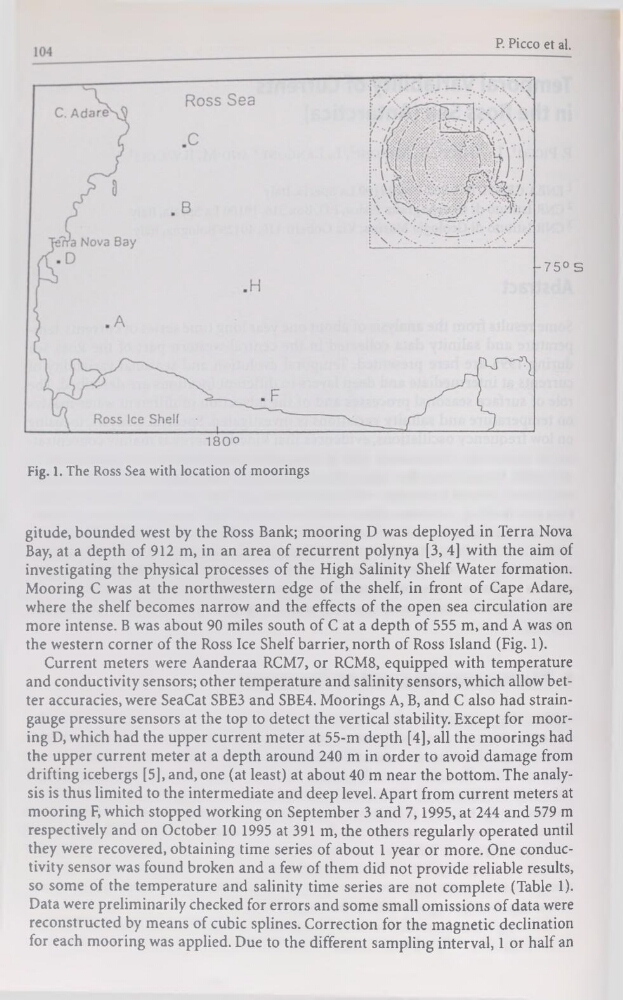
Fig. 1. The Ross Sea with location of moorings
gitude, bounded west by the Ross Bank; mooring D was deployed in Terra Nova
Bay, at a depth of 912 m, in an area of récurrent polynya [3, 4] with the aim of
investigating the physical processes of the High Salinity Shelf Water formation.
Mooring C was at the northwestern edge of the shelf, in front of Cape Adare,
where the shelf becomes narrow and the effects of the open sea circulation are
more intense. B was about 90 miles south of C at a depth of 555 m, and A was on
the western corner of the Ross Ice Shelf barrier, north of Ross Island (Fig. 1).
Current meters were Aanderaa RCM7, or RCM8, equipped with température
and conductivity sensors; other température and salinity sensors, which allowbetter accuracies, were SeaCat SBE3 and SBE4. Moorings A, B, and C also had straingauge pressure sensors at the top to detect the vertical stability. Except for mooring D, which had the upper current meter at 55-m depth [4], ail the moorings had
the upper current meter at a depth around 240 m in order to avoid damage from
drifting icebergs [5], and, one (at least) at about 40 m near the bottom. The analysis is thus limited to the intermediate and deep level. Apart from current meters at
mooring F, which stopped working on September 3 and 7,1995, at 244 and 579 m
respectively and on October 10 1995 at 391 m, the others regularly operated until
they were recovered, obtaining time sériés of about 1 year or more. One conductivity sensor was found broken and a few of them did not provide reliable results,
so some of the température and salinity time sériés are not complété (Table 1).
Data were preliminarily checked for errors and some small omissions of data were
reconstructed by means of cubic splines. Correction for the magnetic déclination
for each mooring was applied. Due to the different sampling interval, 1 or half an
Fig. 1. The Ross Sea with location of moorings
gitude, bounded west by the Ross Bank; mooring D was deployed in Terra Nova
Bay, at a depth of 912 m, in an area of récurrent polynya [3, 4] with the aim of
investigating the physical processes of the High Salinity Shelf Water formation.
Mooring C was at the northwestern edge of the shelf, in front of Cape Adare,
where the shelf becomes narrow and the effects of the open sea circulation are
more intense. B was about 90 miles south of C at a depth of 555 m, and A was on
the western corner of the Ross Ice Shelf barrier, north of Ross Island (Fig. 1).
Current meters were Aanderaa RCM7, or RCM8, equipped with température
and conductivity sensors; other température and salinity sensors, which allowbetter accuracies, were SeaCat SBE3 and SBE4. Moorings A, B, and C also had straingauge pressure sensors at the top to detect the vertical stability. Except for mooring D, which had the upper current meter at 55-m depth [4], ail the moorings had
the upper current meter at a depth around 240 m in order to avoid damage from
drifting icebergs [5], and, one (at least) at about 40 m near the bottom. The analysis is thus limited to the intermediate and deep level. Apart from current meters at
mooring F, which stopped working on September 3 and 7,1995, at 244 and 579 m
respectively and on October 10 1995 at 391 m, the others regularly operated until
they were recovered, obtaining time sériés of about 1 year or more. One conductivity sensor was found broken and a few of them did not provide reliable results,
so some of the température and salinity time sériés are not complété (Table 1).
Data were preliminarily checked for errors and some small omissions of data were
reconstructed by means of cubic splines. Correction for the magnetic déclination
for each mooring was applied. Due to the different sampling interval, 1 or half an