

strength of the hydrothermal input, which is in
turn roughly proportional to the spreading rate of
the ridges. The final distribution is determined by
advection and mixing of the injected hydrothermal
fluids. In the Pacific Ocean, where the ridges are
spreading the fastest, the deep water masses have
the highest
3 He excesses derived from hydrothermal activity. In fact, the deep Pacific is everywhere
enriched in
3
He by about 20% compared with
background values. In the Atlantic Ocean the
mantle helium excess is typically only 1–2%, due
to the much slower spreading rate of the MidAtlantic Ridge, while the Indian Ocean has intermediate mantle
3
He excesses of Ϸ10% above
background.
It has long been recognized that the distribution
of mantle
3
He has great potential for delineating
the patterns of circulation and mixing of deep and
intermediate water masses. This potential is probably greatest in the Pacific Ocean because of the
stronger deep
3 He signal in this ocean. However,
most of the mantle helium sources in the Pacific
are distributed along the East Pacific Rise (EPR)
system in the eastern Pacific and along the Juan de
Fuca Ridge (JdFR) system in the northeast Pacific.
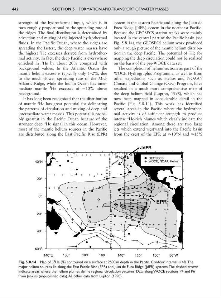
Because the GEOSECS station tracks were mainly
located in the central part of the Pacific basin (see
Fig. 5.8.14), the GEOSECS helium work produced
only a rough picture of the mantle helium distribution in the deep Pacific. The potential of
3
He for
mapping the deep circulation could not be realized
on the basis of the pre-WOCE data set.
The completion of helium sections as part of the
WOCE Hydrographic Programme, as well as from
other expeditions such as Helios and NOAA’s
Climate and Global Change (CGC) Program, have
resulted in a much more comprehensive map of
the deep helium field (Lupton, 1998), which has
now been mapped in considerable detail in the
Pacific (Fig. 5.8.14). This work has identified
several areas in the Pacific where the hydrothermal activity is of sufficient strength to produce
intense
3 He-rich plumes which clearly indicate the
regional circulation. Among these are two large
jets which extend westward into the Pacific basin
from the crest of the EPR at Ϸ10°N and Ϸ15°S
SECTION 5 FORMATION AND TRANSPORT OF WATER MASSES
442
?
140°E
180°
140°
100°
160°
160°
120°
80°W
EPR
GEOSECS
WOCE, NOAA, Helios
JdFR
?
40°N
20°
0°
20°
40°
60°S
Fig. 5.8.14 Map of
3 He (%) contoured on a surface at 2500 m depth in the Pacific. Contour interval is 4%.The
major helium sources lie along the East Pacific Rise (EPR) and Juan de Fuca Ridge (JdFR) systems.The dashed arrows
indicate areas where the helium plumes define regional circulation patterns. Data along WOCE sections P4 and P6
from Jenkins (unpublished data).All other data from Lupton (1998).
turn roughly proportional to the spreading rate of
the ridges. The final distribution is determined by
advection and mixing of the injected hydrothermal
fluids. In the Pacific Ocean, where the ridges are
spreading the fastest, the deep water masses have
the highest
3 He excesses derived from hydrothermal activity. In fact, the deep Pacific is everywhere
enriched in
3
He by about 20% compared with
background values. In the Atlantic Ocean the
mantle helium excess is typically only 1–2%, due
to the much slower spreading rate of the MidAtlantic Ridge, while the Indian Ocean has intermediate mantle
3
He excesses of Ϸ10% above
background.
It has long been recognized that the distribution
of mantle
3
He has great potential for delineating
the patterns of circulation and mixing of deep and
intermediate water masses. This potential is probably greatest in the Pacific Ocean because of the
stronger deep
3 He signal in this ocean. However,
most of the mantle helium sources in the Pacific
are distributed along the East Pacific Rise (EPR)
system in the eastern Pacific and along the Juan de
Fuca Ridge (JdFR) system in the northeast Pacific.
Because the GEOSECS station tracks were mainly
located in the central part of the Pacific basin (see
Fig. 5.8.14), the GEOSECS helium work produced
only a rough picture of the mantle helium distribution in the deep Pacific. The potential of
3
He for
mapping the deep circulation could not be realized
on the basis of the pre-WOCE data set.
The completion of helium sections as part of the
WOCE Hydrographic Programme, as well as from
other expeditions such as Helios and NOAA’s
Climate and Global Change (CGC) Program, have
resulted in a much more comprehensive map of
the deep helium field (Lupton, 1998), which has
now been mapped in considerable detail in the
Pacific (Fig. 5.8.14). This work has identified
several areas in the Pacific where the hydrothermal activity is of sufficient strength to produce
intense
3 He-rich plumes which clearly indicate the
regional circulation. Among these are two large
jets which extend westward into the Pacific basin
from the crest of the EPR at Ϸ10°N and Ϸ15°S
SECTION 5 FORMATION AND TRANSPORT OF WATER MASSES
442
?
140°E
180°
140°
100°
160°
160°
120°
80°W
EPR
GEOSECS
WOCE, NOAA, Helios
JdFR
?
40°N
20°
0°
20°
40°
60°S
Fig. 5.8.14 Map of
3 He (%) contoured on a surface at 2500 m depth in the Pacific. Contour interval is 4%.The
major helium sources lie along the East Pacific Rise (EPR) and Juan de Fuca Ridge (JdFR) systems.The dashed arrows
indicate areas where the helium plumes define regional circulation patterns. Data along WOCE sections P4 and P6
from Jenkins (unpublished data).All other data from Lupton (1998).