

required and path, mean buoyancy and transport
derived. But hydrographic data alone and that collected over a 2-month period does not allow a critical evaluation of the model.
Baringer and Price (1997b) employed similar
equations for the Mediterranean outflow but
allowed both the bottom drag coefficient and
interfacial drag, assumed determined by the
Richardson number, to be observable quantities.
The along-stream momentum equation was shown
to yield the following balance:
along stream change of kinetic energy and internal potential energy of plume PLUS the change
in external potential energy EQUALS the drag
of the bottom and surrounding fluid.
1
The first two terms represent the slowing and flattening of the plume, the third the descent across
contours. Based on observations made in the
Mediterranean outflow (Johnson et al., 1994b)
and on the Blake outer ridge (Stahr and Sanford,
1999) it seems likely that, except very close to the
sill, the principal balance is between descent and
bottom drag. However, no detailed study of either
of the northern overflows has yet been reported.
A development of the streamtube concept, a
hybrid betwen analytical and fully numerical models (the latter considered in the next section), has
been developed by Jungclaus and Backhaus
(1994). Its integrated properties are similar to the
Smith model, but it resolves the plume horizontally identifying the location of the core. The
impact of topographic irregularities can also be
studied, and in this respect it offers the potential
to answer questions about steeply draining flow
(see Section 5.6.2).
5.6.6 Numerical models of the overflow
For numerical ocean models that are global
in character, there are two difficulties with the
representation of the overflows. The first is concerned with the horizontal resolution of the channels through which the overflows emerge, and the
second with the vertical resolution with which
overflows are described. For regional models (say
covering the North Atlantic), in addition to the
above difficulties experience has shown that it is
essential to place the northern boundary well
north of the Greenland–Iceland–Scotland Ridge
(Willebrand et al., 2000).
For coarse-resolution models (91°), such as are
employed in climate modelling, the first difficulty
is the most severe. In order to allow access
between ocean basins it will be essential to widen
channels unrealistically. For coarse vertical resolution it may also be necessary to deepen them
excessively, too. Roberts and Wood (1997) illustrated these problems using a level model.
For fine-resolution models (:1/4° and as fine
as 1/10°) the former difficulty is less severe,
although ideally several gridpoints should span the
channel. But even where there is good model vertical resolution at shallow depths, say 50 m intervals
at 500 m, as the overflow descends the model vertical resolution coarsens, to something like 200-m
intervals in excess of 2000 m in current models,
which results in only one or two grid levels
describing the vertical extent of the overflow.
The DYNAMO project (DYNAMO Group,
1997) was designed to compare the performance
of level, isopycnal and sigma coordinate (terrainfollowing) eddy-permitting models with near identical initial conditions and forcing (Willebrand
et al., 2000). Their experience with respect to the
overflow may be summarized as follows. The level
model by virtue of its stepped seabed gives rise to
unrealistic downslope spillage and consequent vertical convection, which mix away the overflow
properties too rapidly. The sigma model has a similar defect with its excessive mixing also enhanced
SECTION 5 FORMATION AND TRANSPORT OF WATER MASSES
414
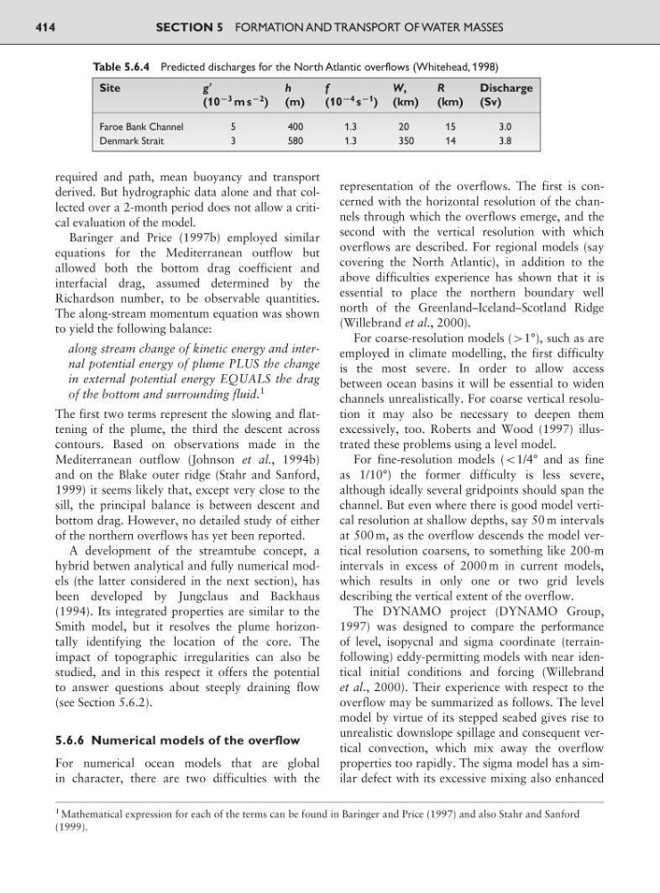
Table 5.6.4 Predicted discharges for the North Atlantic overflows (Whitehead, 1998)
Site
gЈ
h
f
W,
R
Discharge
(10
93 m s
92
) (m)
(10
94 s
91
) (km)
(km) (Sv)
Faroe Bank Channel
5
400
1.3
2 0
1 5
3 .0
Denmark Strait
3
580
1.3
350
14
3.8
1 Mathematical expression for each of the terms can be found in Baringer and Price (1997) and also Stahr and Sanford
(1999).
derived. But hydrographic data alone and that collected over a 2-month period does not allow a critical evaluation of the model.
Baringer and Price (1997b) employed similar
equations for the Mediterranean outflow but
allowed both the bottom drag coefficient and
interfacial drag, assumed determined by the
Richardson number, to be observable quantities.
The along-stream momentum equation was shown
to yield the following balance:
along stream change of kinetic energy and internal potential energy of plume PLUS the change
in external potential energy EQUALS the drag
of the bottom and surrounding fluid.
1
The first two terms represent the slowing and flattening of the plume, the third the descent across
contours. Based on observations made in the
Mediterranean outflow (Johnson et al., 1994b)
and on the Blake outer ridge (Stahr and Sanford,
1999) it seems likely that, except very close to the
sill, the principal balance is between descent and
bottom drag. However, no detailed study of either
of the northern overflows has yet been reported.
A development of the streamtube concept, a
hybrid betwen analytical and fully numerical models (the latter considered in the next section), has
been developed by Jungclaus and Backhaus
(1994). Its integrated properties are similar to the
Smith model, but it resolves the plume horizontally identifying the location of the core. The
impact of topographic irregularities can also be
studied, and in this respect it offers the potential
to answer questions about steeply draining flow
(see Section 5.6.2).
5.6.6 Numerical models of the overflow
For numerical ocean models that are global
in character, there are two difficulties with the
representation of the overflows. The first is concerned with the horizontal resolution of the channels through which the overflows emerge, and the
second with the vertical resolution with which
overflows are described. For regional models (say
covering the North Atlantic), in addition to the
above difficulties experience has shown that it is
essential to place the northern boundary well
north of the Greenland–Iceland–Scotland Ridge
(Willebrand et al., 2000).
For coarse-resolution models (91°), such as are
employed in climate modelling, the first difficulty
is the most severe. In order to allow access
between ocean basins it will be essential to widen
channels unrealistically. For coarse vertical resolution it may also be necessary to deepen them
excessively, too. Roberts and Wood (1997) illustrated these problems using a level model.
For fine-resolution models (:1/4° and as fine
as 1/10°) the former difficulty is less severe,
although ideally several gridpoints should span the
channel. But even where there is good model vertical resolution at shallow depths, say 50 m intervals
at 500 m, as the overflow descends the model vertical resolution coarsens, to something like 200-m
intervals in excess of 2000 m in current models,
which results in only one or two grid levels
describing the vertical extent of the overflow.
The DYNAMO project (DYNAMO Group,
1997) was designed to compare the performance
of level, isopycnal and sigma coordinate (terrainfollowing) eddy-permitting models with near identical initial conditions and forcing (Willebrand
et al., 2000). Their experience with respect to the
overflow may be summarized as follows. The level
model by virtue of its stepped seabed gives rise to
unrealistic downslope spillage and consequent vertical convection, which mix away the overflow
properties too rapidly. The sigma model has a similar defect with its excessive mixing also enhanced
SECTION 5 FORMATION AND TRANSPORT OF WATER MASSES
414
Table 5.6.4 Predicted discharges for the North Atlantic overflows (Whitehead, 1998)
Site
gЈ
h
f
W,
R
Discharge
(10
93 m s
92
) (m)
(10
94 s
91
) (km)
(km) (Sv)
Faroe Bank Channel
5
400
1.3
2 0
1 5
3 .0
Denmark Strait
3
580
1.3
350
14
3.8
1 Mathematical expression for each of the terms can be found in Baringer and Price (1997) and also Stahr and Sanford
(1999).