

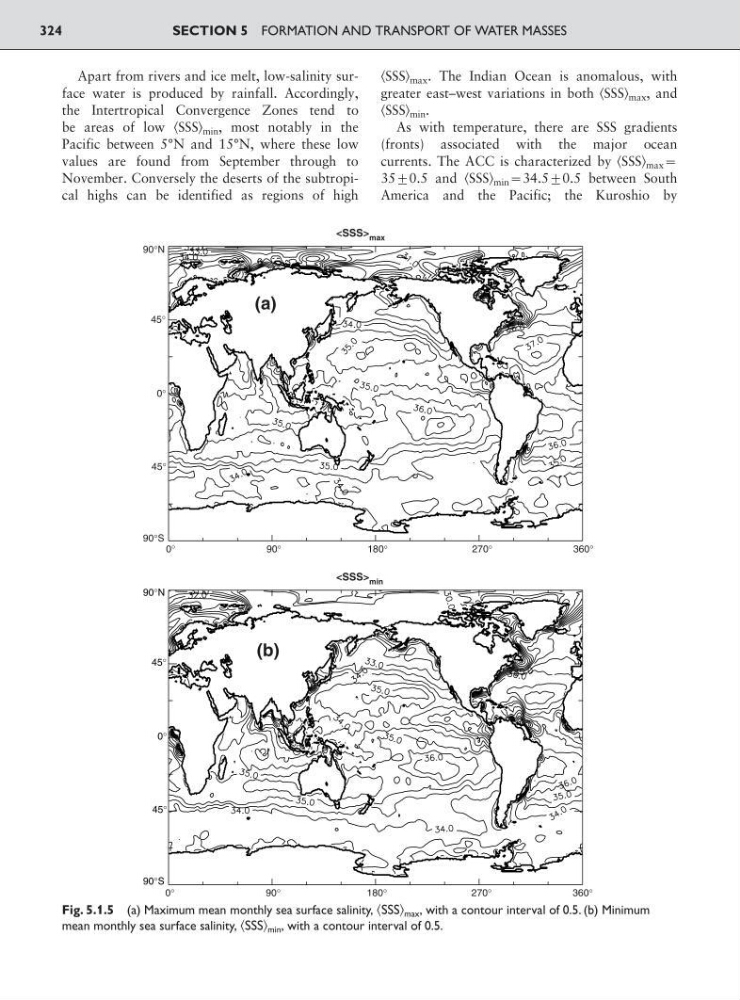
Apart from rivers and ice melt, low-salinity surface water is produced by rainfall. Accordingly,
the Intertropical Convergence Zones tend to
be areas of low ͗SSS͘ min , most notably in the
Pacific between 5°N and 15°N, where these low
values are found from September through to
November. Conversely the deserts of the subtropical highs can be identified as regions of high
͗SSS͘ max . The Indian Ocean is anomalous, with
greater east–west variations in both ͗SSS͘ max , and
͗SSS͘ min .
As with temperature, there are SSS gradients
(fronts) associated with the major ocean
currents. The ACC is characterized by ͗SSS͘ max :
35<0.5 and ͗SSS͘ min :34.5<0.5 between South
America and the Pacific; the Kuroshio by
SECTION 5 FORMATION AND TRANSPORT OF WATER MASSES
324
90°N
90°S
45°
45°
0°
0°
90°
180°
270°
360°
0°
90°
180°
270°
360°
90°N
90°S
45°
45°
0°
(a)
(b)
max
min
Fig. 5.1.5 (a) Maximum mean monthly sea surface salinity, ͗SSS͘ max , with a contour interval of 0.5. (b) Minimum
mean monthly sea surface salinity, ͗SSS͘ min , with a contour interval of 0.5.
the Intertropical Convergence Zones tend to
be areas of low ͗SSS͘ min , most notably in the
Pacific between 5°N and 15°N, where these low
values are found from September through to
November. Conversely the deserts of the subtropical highs can be identified as regions of high
͗SSS͘ max . The Indian Ocean is anomalous, with
greater east–west variations in both ͗SSS͘ max , and
͗SSS͘ min .
As with temperature, there are SSS gradients
(fronts) associated with the major ocean
currents. The ACC is characterized by ͗SSS͘ max :
35<0.5 and ͗SSS͘ min :34.5<0.5 between South
America and the Pacific; the Kuroshio by
SECTION 5 FORMATION AND TRANSPORT OF WATER MASSES
324
90°N
90°S
45°
45°
0°
0°
90°
180°
270°
360°
0°
90°
180°
270°
360°
90°N
90°S
45°
45°
0°
(a)
(b)
Fig. 5.1.5 (a) Maximum mean monthly sea surface salinity, ͗SSS͘ max , with a contour interval of 0.5. (b) Minimum
mean monthly sea surface salinity, ͗SSS͘ min , with a contour interval of 0.5.