

possibility of three western boundary currents.
Moored arrays were placed across each along 20°S
(nos 11–13). In addition, measurements of the deep
boundary currents along the African coast north of
Madagascar at 10°S (no. 10) and on the Southeast
Indian Ridge near 30°S (no. 16) were proposed but
did not happen.
4.5.2.1 The Pacific
Deep water flows into the Pacific from the south
along the Continental Rise east of New Zealand
and makes its way northward through the Samoan
Passage at 10°S. The WOCE period measurements
have served mainly to quantify the transports in
this region. An ambitious array of 60 current
meters on 20 moorings was placed from the 3000 m
isobath on the Tonga–Kermadec Ridge to a point
more than 10° further offshore (Whitworth et al.,
1999; no. 21, Fig. 4.5.2). The spatially integrated
and time-averaged flow of CDW over the 22month measurement period was calculated to be
15.8 Sv while the root-mean-square (rms) variability
was a large fraction of this at 9.2 Sv. This variability
arose from low-frequency motions at several identifiable periods: 50 days, 20 days and 10 days. Taking the longest as the most conservative to use in
calculations of degrees of freedom, the indicated
zero crossing of the time-lagged correlation function would be at about 12.5 days (i.e. a quarter
period) and the integral from zero to this point of
order 8 days, say (it would be 6.25 days if the correlation dropped linearly from unity to zero over
this interval). Thus, from 22 months of measurements there are about 40 degrees of freedom and
the standard error of the mean transport is about
1.4 Sv, as shown in Fig. 4.5.3.
Some 20° to the north at the Samoan Passage,
Roemmich et al. (1996; no. 22, Fig. 4.5.2)
reported a mean northward transport of bottom
water of 10.6 Sv with a standard error of 1.7 Sv
from an 18-month measurement programme. Here
again there is substantial variability centred on
periods of 30 days, which Rudnick (1997) hypothesized results from a topographically induced resonance. Of the 10.7 Sv total transport only 7.1 Sv
flows directly through the passage: the rest is
through a gap in the Robbie Ridge to the west
(1.1 Sv) and along the flanks of the Manihiki
Plateau to the east (2.8 Sv), both estimates coming
from dynamic calculations performed on single
hydrographic sections. This natural variability
easily encompasses the range of transport estimates
4.5 Quantification of the Deep Circulation
261
Hogg
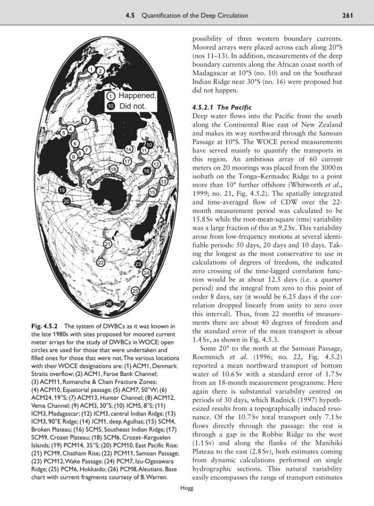
Fig. 4.5.2 The system of DWBCs as it was known in
the late 1980s with sites proposed for moored current
meter arrays for the study of DWBCs in WOCE: open
circles are used for those that were undertaken and
filled ones for those that were not.The various locations
with their WOCE designations are: (1) ACM1, Denmark
Straits overflow; (2) ACM1, Faroe Bank Channel;
(3) ACM11, Romanche & Chain Fracture Zones;
(4) ACM10, Equatorial passage; (5) ACM7, 50°W; (6)
ACM24, 19°S; (7) ACM13, Hunter Channel; (8) ACM12,
Vema Channel; (9) ACM3, 30°S; (10) ICM5, 8°S; (11)
ICM3, Madagascar; (12) ICM3, central Indian Ridge; (13)
ICM3, 90°E Ridge; (14) ICM1, deep Agulhas; (15) SCM4,
Broken Plateau; (16) SCM5, Southeast Indian Ridge; (17)
SCM9, Crozet Plateau; (18) SCM6, Crozet–Kerguelen
Islands; (19) PCM14, 35°S; (20) PCM10, East Pacific Rise;
(21) PCM9, Chatham Rise; (22) PCM11, Samoan Passage;
(23) PCM12,Wake Passage; (24) PCM7, Izu-Ogasawara
Ridge; (25) PCM6, Hokkaido; (26) PCM8,Aleutians. Base
chart with current fragments courtesy of B.Warren.
Moored arrays were placed across each along 20°S
(nos 11–13). In addition, measurements of the deep
boundary currents along the African coast north of
Madagascar at 10°S (no. 10) and on the Southeast
Indian Ridge near 30°S (no. 16) were proposed but
did not happen.
4.5.2.1 The Pacific
Deep water flows into the Pacific from the south
along the Continental Rise east of New Zealand
and makes its way northward through the Samoan
Passage at 10°S. The WOCE period measurements
have served mainly to quantify the transports in
this region. An ambitious array of 60 current
meters on 20 moorings was placed from the 3000 m
isobath on the Tonga–Kermadec Ridge to a point
more than 10° further offshore (Whitworth et al.,
1999; no. 21, Fig. 4.5.2). The spatially integrated
and time-averaged flow of CDW over the 22month measurement period was calculated to be
15.8 Sv while the root-mean-square (rms) variability
was a large fraction of this at 9.2 Sv. This variability
arose from low-frequency motions at several identifiable periods: 50 days, 20 days and 10 days. Taking the longest as the most conservative to use in
calculations of degrees of freedom, the indicated
zero crossing of the time-lagged correlation function would be at about 12.5 days (i.e. a quarter
period) and the integral from zero to this point of
order 8 days, say (it would be 6.25 days if the correlation dropped linearly from unity to zero over
this interval). Thus, from 22 months of measurements there are about 40 degrees of freedom and
the standard error of the mean transport is about
1.4 Sv, as shown in Fig. 4.5.3.
Some 20° to the north at the Samoan Passage,
Roemmich et al. (1996; no. 22, Fig. 4.5.2)
reported a mean northward transport of bottom
water of 10.6 Sv with a standard error of 1.7 Sv
from an 18-month measurement programme. Here
again there is substantial variability centred on
periods of 30 days, which Rudnick (1997) hypothesized results from a topographically induced resonance. Of the 10.7 Sv total transport only 7.1 Sv
flows directly through the passage: the rest is
through a gap in the Robbie Ridge to the west
(1.1 Sv) and along the flanks of the Manihiki
Plateau to the east (2.8 Sv), both estimates coming
from dynamic calculations performed on single
hydrographic sections. This natural variability
easily encompasses the range of transport estimates
4.5 Quantification of the Deep Circulation
261
Hogg
Fig. 4.5.2 The system of DWBCs as it was known in
the late 1980s with sites proposed for moored current
meter arrays for the study of DWBCs in WOCE: open
circles are used for those that were undertaken and
filled ones for those that were not.The various locations
with their WOCE designations are: (1) ACM1, Denmark
Straits overflow; (2) ACM1, Faroe Bank Channel;
(3) ACM11, Romanche & Chain Fracture Zones;
(4) ACM10, Equatorial passage; (5) ACM7, 50°W; (6)
ACM24, 19°S; (7) ACM13, Hunter Channel; (8) ACM12,
Vema Channel; (9) ACM3, 30°S; (10) ICM5, 8°S; (11)
ICM3, Madagascar; (12) ICM3, central Indian Ridge; (13)
ICM3, 90°E Ridge; (14) ICM1, deep Agulhas; (15) SCM4,
Broken Plateau; (16) SCM5, Southeast Indian Ridge; (17)
SCM9, Crozet Plateau; (18) SCM6, Crozet–Kerguelen
Islands; (19) PCM14, 35°S; (20) PCM10, East Pacific Rise;
(21) PCM9, Chatham Rise; (22) PCM11, Samoan Passage;
(23) PCM12,Wake Passage; (24) PCM7, Izu-Ogasawara
Ridge; (25) PCM6, Hokkaido; (26) PCM8,Aleutians. Base
chart with current fragments courtesy of B.Warren.