

focused, instead, on a small region of the South
Atlantic – the Brazil Basin – in a programme known
as the Deep Basin Experiment (DBE), results from
which are described in Section 4.5.3. A brief summary ends this chapter (Section 4.5.4).
4.5.2 Deep Western Boundary Currents
After Stommel proposed his deep circulation
scheme, Swallow and Worthington (1957, 1961)
quickly discovered the DWBC off the east coast of
the USA using traditional hydrographic measurements and the newly developed, neutrally buoyant
float (the ‘Swallow float’). Although the signature
of the DWBC had certainly been recognized earlier
by Wüst (1935) in the Meteor hydrographic sections across the Atlantic, the direct velocity measurements were not subject to the usual reference
level issues. But recognition that these deep boundary currents carry water that has been in recent
contact with the atmosphere has allowed investigators to identify them from section data and build a
fragmentary picture of their global distribution
(Fig. 4.5.2). At the beginning of WOCE the deep
Pacific was relatively unexplored: on the basis
of a small number of hydrographic sections and
measurements within the Samoan Passage (at 10°S,
no. 22 on Fig. 4.5.2) it was known that Circumpolar
Deep Water (CDW, more loosely called Antarctic
Bottom Water or AABW) flowed northward along
the western boundary, but its entry into and
circulation within the North Pacific was less well
mapped out. Hence the call for four moored arrays
along the western boundary, two of which did not
occur – the one south of the Aleutians (no. 26,
Fig. 4.5.2) and another in Wake Passage (no. 23).
Two arrays were suggested for the eastern South
Pacific, one to explore the possible flow northward
along the eastern flank of the East Pacific Rise
(no. 20) and the other to investigate the deep flow
along the coast of South America at 35°S (no. 19).
Neither was attempted.
Historically, the Atlantic has been much better
measured. Through the systematic sampling of
hydrographic programmes such as the Meteor
Expedition of the 1920s and the International Geophysical Year of the 1950s, the network of DWBCs
has been sketched out relatively well, although
quantified in only a few places with moored arrays.
Within the Atlantic sector it was proposed to establish new moored arrays, mainly to measure the
overflows from the Greenland and Iceland Seas
(nos 1 and 2) and in support of the DBE (nos 3–9,
see Section 4.5.3).
The entry of AABW into the southern Indian
Ocean was explored with three arrays (nos 15,
17 and 18). In this ocean there are two major
meridionally oriented ridge systems that give the
SECTION 4 THE GLOBAL FLOW FIELD
260
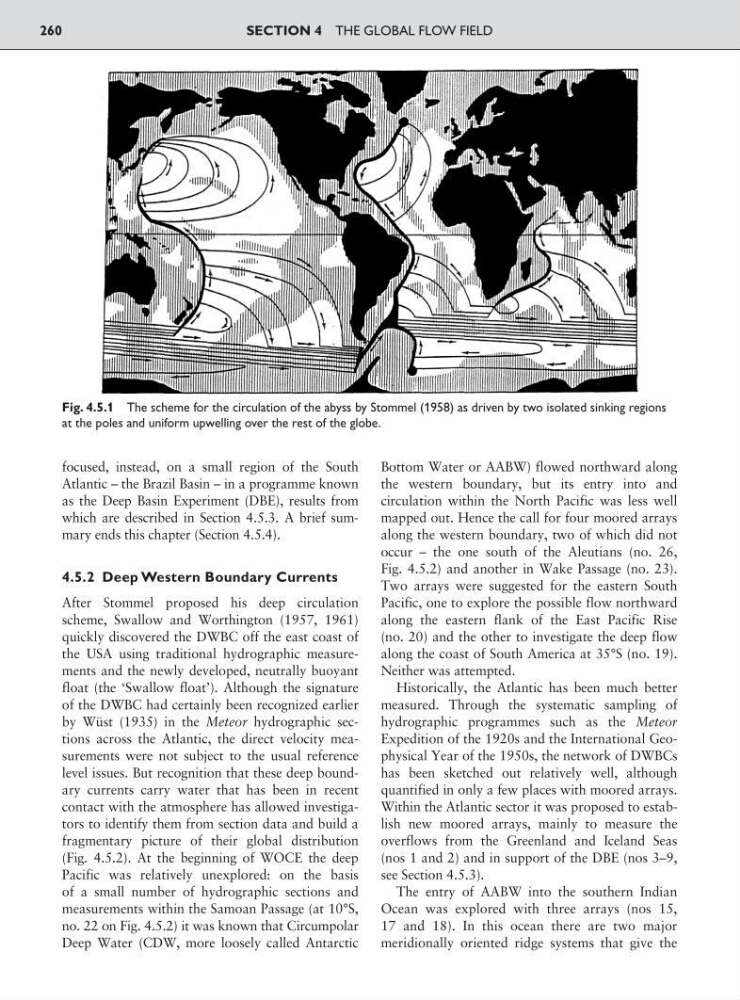
Fig. 4.5.1 The scheme for the circulation of the abyss by Stommel (1958) as driven by two isolated sinking regions
at the poles and uniform upwelling over the rest of the globe.
Atlantic – the Brazil Basin – in a programme known
as the Deep Basin Experiment (DBE), results from
which are described in Section 4.5.3. A brief summary ends this chapter (Section 4.5.4).
4.5.2 Deep Western Boundary Currents
After Stommel proposed his deep circulation
scheme, Swallow and Worthington (1957, 1961)
quickly discovered the DWBC off the east coast of
the USA using traditional hydrographic measurements and the newly developed, neutrally buoyant
float (the ‘Swallow float’). Although the signature
of the DWBC had certainly been recognized earlier
by Wüst (1935) in the Meteor hydrographic sections across the Atlantic, the direct velocity measurements were not subject to the usual reference
level issues. But recognition that these deep boundary currents carry water that has been in recent
contact with the atmosphere has allowed investigators to identify them from section data and build a
fragmentary picture of their global distribution
(Fig. 4.5.2). At the beginning of WOCE the deep
Pacific was relatively unexplored: on the basis
of a small number of hydrographic sections and
measurements within the Samoan Passage (at 10°S,
no. 22 on Fig. 4.5.2) it was known that Circumpolar
Deep Water (CDW, more loosely called Antarctic
Bottom Water or AABW) flowed northward along
the western boundary, but its entry into and
circulation within the North Pacific was less well
mapped out. Hence the call for four moored arrays
along the western boundary, two of which did not
occur – the one south of the Aleutians (no. 26,
Fig. 4.5.2) and another in Wake Passage (no. 23).
Two arrays were suggested for the eastern South
Pacific, one to explore the possible flow northward
along the eastern flank of the East Pacific Rise
(no. 20) and the other to investigate the deep flow
along the coast of South America at 35°S (no. 19).
Neither was attempted.
Historically, the Atlantic has been much better
measured. Through the systematic sampling of
hydrographic programmes such as the Meteor
Expedition of the 1920s and the International Geophysical Year of the 1950s, the network of DWBCs
has been sketched out relatively well, although
quantified in only a few places with moored arrays.
Within the Atlantic sector it was proposed to establish new moored arrays, mainly to measure the
overflows from the Greenland and Iceland Seas
(nos 1 and 2) and in support of the DBE (nos 3–9,
see Section 4.5.3).
The entry of AABW into the southern Indian
Ocean was explored with three arrays (nos 15,
17 and 18). In this ocean there are two major
meridionally oriented ridge systems that give the
SECTION 4 THE GLOBAL FLOW FIELD
260
Fig. 4.5.1 The scheme for the circulation of the abyss by Stommel (1958) as driven by two isolated sinking regions
at the poles and uniform upwelling over the rest of the globe.