

because of the Amazon and, to a lesser extent,
the Orinoco and Mississippi), but the greatest input
per unit basin area is in the Arctic (28 cm y
À1 if evenly
distributed over the entire basin). The least discharge
per unit area of ocean basin is the South Pacific
(4.5 cm y
À1 distributed over the entire basin). In terms
of suspended sediment load, the major sinks are the
Pacific and Indian oceans (11.1 and 4 Â 10
9 t y
À1
,
respectively), whereas the North Atlantic is the major
sink for dissolved solids (1.35 Â 10
9 t y
À1
; Table 4),
largely due to the high dissolved loads of European
and eastern North American rivers.
This is not to say, of course, that the fresh water or
its suspended and dissolved loads are evenly distributed throughout the ocean basins. In fact, most
fluvial identity is lost soon after the river discharges
into the ocean due to mixing, flocculation, and
chemical uptake. In many rivers, much of the sediment is sequestered on deltas or in the coastal zone.
In most broad, passive margins, in fact, little sediment presently escapes the inner shelf, and very little
reaches the outer continental margin. During low
stands of sea level, on the other hand, most fluvial
sediment is discharged directly to the deep sea, where
it can be redistributed far from its source(s) via mass
wasting (e.g., slumping and turbidity currents). This
contrast between sediment discharge from passive
margins during high and low stands of sea level is the
underlying basis for sequence stratigraphy. However,
in narrow active margins, often bordered by young
mountains, many rivers are relatively small (e.g., the
western Americas, East Indies) and therefore often
more responsive to episodic events. As such, sediment can escape the relatively narrow continental
shelves, although the ultimate fate of this sediment is
still not well documented.
Changes in Fluvial Processes and
Fluxes – Natural and Anthropogenic
The preceding discussion is based mostly on data
collected in the past 50 years. In most cases it reflects
neither natural conditions nor long-term conditions
representing the geological past. While the subject is
still being actively debated, there seems little question that river discharge during the last glacial
maximum (LGM), 15 000–20 000 years ago, differed
greatly from present-day patterns. Northern rivers
were either seasonal or did not flow except during
periodic ice melts. Humid and sub-humid tropical
watersheds, on the other hand, may have experienced far less precipitation than they do at present.
With the post-LGM climatic warming and ensuing
ice melt, river flow increased. Scattered terrestrial
and marine data suggest that during the latest Pleistocene and earliest Holocene, erosion rates and
sediment delivery increased dramatically as glacially
eroded debris was transported by increased river
flow. As vegetation became more firmly established
in the mid-Holocene, however, erosion rates apparently decreased, and perhaps would have remained
relatively low except for human interference.
10
100
1000
0.01
0.1
11
0
100
1000 10 000
SE Asia
0.01
0.001
0.1
1
10
100
1000
10 000
Dissolved solid load (x10 t y )
6
_ 1
0.01
0.1
1
10
100
1000 10 000
(A)
Asia/ Africa / S Amer.
Eurasian Arctic
Dissolved solids (mg /
l)
(B)
Drainage basin area (x10 km )
3
2
Drainage basin area (x10 km )
3
2
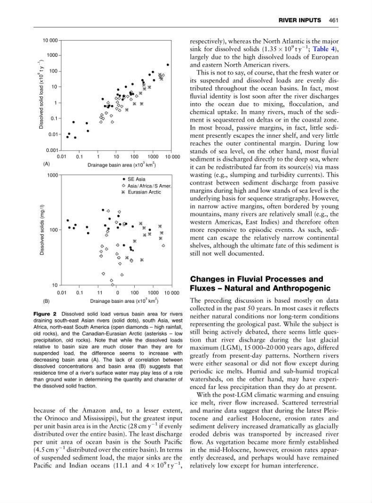
Figure 2 Dissolved solid load versus basin area for rivers
draining south-east Asian rivers (solid dots), south Asia, west
Africa, north-east South America (open diamonds – high rainfall,
old rocks), and the Canadian-Eurasian Arctic (asterisks – low
precipitation, old rocks). Note that while the dissolved loads
relative to basin size are much closer than they are for
suspended load, the difference seems to increase with
decreasing basin area (A). The lack of correlation between
dissolved concentrations and basin area (B) suggests that
residence time of a river’s surface water may play less of a role
than ground water in determining the quantity and character of
the dissolved solid fraction.
RIVER INPUTS 461
the Orinoco and Mississippi), but the greatest input
per unit basin area is in the Arctic (28 cm y
À1 if evenly
distributed over the entire basin). The least discharge
per unit area of ocean basin is the South Pacific
(4.5 cm y
À1 distributed over the entire basin). In terms
of suspended sediment load, the major sinks are the
Pacific and Indian oceans (11.1 and 4 Â 10
9 t y
À1
,
respectively), whereas the North Atlantic is the major
sink for dissolved solids (1.35 Â 10
9 t y
À1
; Table 4),
largely due to the high dissolved loads of European
and eastern North American rivers.
This is not to say, of course, that the fresh water or
its suspended and dissolved loads are evenly distributed throughout the ocean basins. In fact, most
fluvial identity is lost soon after the river discharges
into the ocean due to mixing, flocculation, and
chemical uptake. In many rivers, much of the sediment is sequestered on deltas or in the coastal zone.
In most broad, passive margins, in fact, little sediment presently escapes the inner shelf, and very little
reaches the outer continental margin. During low
stands of sea level, on the other hand, most fluvial
sediment is discharged directly to the deep sea, where
it can be redistributed far from its source(s) via mass
wasting (e.g., slumping and turbidity currents). This
contrast between sediment discharge from passive
margins during high and low stands of sea level is the
underlying basis for sequence stratigraphy. However,
in narrow active margins, often bordered by young
mountains, many rivers are relatively small (e.g., the
western Americas, East Indies) and therefore often
more responsive to episodic events. As such, sediment can escape the relatively narrow continental
shelves, although the ultimate fate of this sediment is
still not well documented.
Changes in Fluvial Processes and
Fluxes – Natural and Anthropogenic
The preceding discussion is based mostly on data
collected in the past 50 years. In most cases it reflects
neither natural conditions nor long-term conditions
representing the geological past. While the subject is
still being actively debated, there seems little question that river discharge during the last glacial
maximum (LGM), 15 000–20 000 years ago, differed
greatly from present-day patterns. Northern rivers
were either seasonal or did not flow except during
periodic ice melts. Humid and sub-humid tropical
watersheds, on the other hand, may have experienced far less precipitation than they do at present.
With the post-LGM climatic warming and ensuing
ice melt, river flow increased. Scattered terrestrial
and marine data suggest that during the latest Pleistocene and earliest Holocene, erosion rates and
sediment delivery increased dramatically as glacially
eroded debris was transported by increased river
flow. As vegetation became more firmly established
in the mid-Holocene, however, erosion rates apparently decreased, and perhaps would have remained
relatively low except for human interference.
10
100
1000
0.01
0.1
11
0
100
1000 10 000
SE Asia
0.01
0.001
0.1
1
10
100
1000
10 000
Dissolved solid load (x10 t y )
6
_ 1
0.01
0.1
1
10
100
1000 10 000
(A)
Asia/ Africa / S Amer.
Eurasian Arctic
Dissolved solids (mg /
l)
(B)
Drainage basin area (x10 km )
3
2
Drainage basin area (x10 km )
3
2
Figure 2 Dissolved solid load versus basin area for rivers
draining south-east Asian rivers (solid dots), south Asia, west
Africa, north-east South America (open diamonds – high rainfall,
old rocks), and the Canadian-Eurasian Arctic (asterisks – low
precipitation, old rocks). Note that while the dissolved loads
relative to basin size are much closer than they are for
suspended load, the difference seems to increase with
decreasing basin area (A). The lack of correlation between
dissolved concentrations and basin area (B) suggests that
residence time of a river’s surface water may play less of a role
than ground water in determining the quantity and character of
the dissolved solid fraction.
RIVER INPUTS 461