

CoastGIS’99: geomatics and coastal environment
Dam trapping efficiency
Dam trapping efficiency (TE), which is the percentage of the natural
suspended sediment flux trapped in the reservoir, can be estimated
using the hydraulic residence time (Vorosmarty d al., 1997). On a
regional scale, the impact of several clams can be assessed by taking into
account the spatial organization of dams along the river network. A
method to estimate the global trapping efficiency (TEw), for any watershed containing more than one dam has been proposed (Maneux, 1998;
Maneux d al., submitted). Thus, TF.w may respectively reach 40% and
70% in the lower reaches of the Dordogne and Lot rivers.
Positive correlation between clrainage areas and river sediment loads
corrected for dam retention, as well as comparisons between TEw-corrected
sediment yields and sediment yields measured up stream from the
dams, highlight the interest of the method in reconstituting natural
sediment yields. This correction let us estimate the impact of river
regulation on river transport capacity. Corrected sediment yields can
then be compared with the spatial analysis of soil erosion risk.
Soil erosion risk assessment
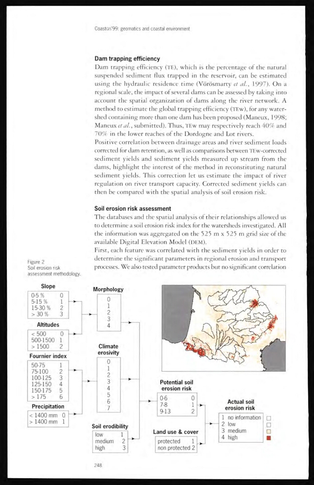
The databases and the spatial analysis of their relationships allowed ns
to determine a soil erosion risk index for the watersheds investigated. All
the information was aggregated on the 525) m x 525 m grid size of the
available Digital Elevation Model (DEM).
First, each feature was correlated with the sediment yielcls in order to
determine the significant parameters in regional erosion and transport
processes. We also tested parameter products but no significant correlation
Figure 2
Soil erosion risk
assessment methodology.
248
Dam trapping efficiency
Dam trapping efficiency (TE), which is the percentage of the natural
suspended sediment flux trapped in the reservoir, can be estimated
using the hydraulic residence time (Vorosmarty d al., 1997). On a
regional scale, the impact of several clams can be assessed by taking into
account the spatial organization of dams along the river network. A
method to estimate the global trapping efficiency (TEw), for any watershed containing more than one dam has been proposed (Maneux, 1998;
Maneux d al., submitted). Thus, TF.w may respectively reach 40% and
70% in the lower reaches of the Dordogne and Lot rivers.
Positive correlation between clrainage areas and river sediment loads
corrected for dam retention, as well as comparisons between TEw-corrected
sediment yields and sediment yields measured up stream from the
dams, highlight the interest of the method in reconstituting natural
sediment yields. This correction let us estimate the impact of river
regulation on river transport capacity. Corrected sediment yields can
then be compared with the spatial analysis of soil erosion risk.
Soil erosion risk assessment
The databases and the spatial analysis of their relationships allowed ns
to determine a soil erosion risk index for the watersheds investigated. All
the information was aggregated on the 525) m x 525 m grid size of the
available Digital Elevation Model (DEM).
First, each feature was correlated with the sediment yielcls in order to
determine the significant parameters in regional erosion and transport
processes. We also tested parameter products but no significant correlation
Figure 2
Soil erosion risk
assessment methodology.
248