

Environmental and resource applications
was found. We then applied the soil erosion assessment methodology
(reclassing and overlay) already used by Corine (1992) to our databases.
Finally, four classes of soil erosion risk weredetermined; the spatial information is presented within the basin limits in figure 2.
In order to integrate spatial information at the watershed level, we
propose to use an index which takes the surface ratro between different
soil erosion classes into account. Thus, the soil erosion index, I
t
,
ro
, for
a watershed was determined as follows:
area(risk>2)
area (risk > 2)
total area
total area
I
tn
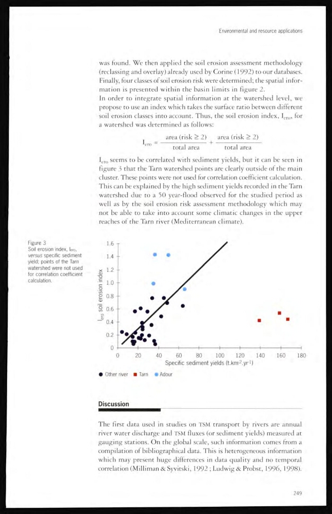
, seems to be correlated with sediment yields, but it can be seen in
figure 3 that the Tarn watershed points are clearly outside of the main
cluster. These points were not used for correlation coefficient calculation.
This can be explained by the high sediment yields recorded in the Tarn
watershed due to a 30 year-flood observed for the studied period as
well as by the soil erosion risk assessment methodology which may
not be able to take into account some climatic changes in the upper
reaches of the Tarn river (Mediterranean climate).
Figure 3
Soil erosion index, lero,
versus specific sediment
yield; points of the Tarn
watershed were not used
for correlation coefficient
calculation.
Discussion
The first data used in studies on TSM transport by rivers are annual
river water discharge and TSM fluxes (or sediment yields) measured at
gauging stations. On the global scale, such information comes from a
compilation of bibliographical data. This is heterogeneous information
which may present huge differences in data quality and no temporal
correlation (Milliman & Syvitski, 1992 ; Ludwig & Probst, 1996, 1998).
249
was found. We then applied the soil erosion assessment methodology
(reclassing and overlay) already used by Corine (1992) to our databases.
Finally, four classes of soil erosion risk weredetermined; the spatial information is presented within the basin limits in figure 2.
In order to integrate spatial information at the watershed level, we
propose to use an index which takes the surface ratro between different
soil erosion classes into account. Thus, the soil erosion index, I
t
,
ro
, for
a watershed was determined as follows:
area(risk>2)
area (risk > 2)
total area
total area
I
tn
, seems to be correlated with sediment yields, but it can be seen in
figure 3 that the Tarn watershed points are clearly outside of the main
cluster. These points were not used for correlation coefficient calculation.
This can be explained by the high sediment yields recorded in the Tarn
watershed due to a 30 year-flood observed for the studied period as
well as by the soil erosion risk assessment methodology which may
not be able to take into account some climatic changes in the upper
reaches of the Tarn river (Mediterranean climate).
Figure 3
Soil erosion index, lero,
versus specific sediment
yield; points of the Tarn
watershed were not used
for correlation coefficient
calculation.
Discussion
The first data used in studies on TSM transport by rivers are annual
river water discharge and TSM fluxes (or sediment yields) measured at
gauging stations. On the global scale, such information comes from a
compilation of bibliographical data. This is heterogeneous information
which may present huge differences in data quality and no temporal
correlation (Milliman & Syvitski, 1992 ; Ludwig & Probst, 1996, 1998).
249