

29
Dynamic Earth
North
American
plate
South
American
plate
African
plate
Eurasian
plate
Eurasian
plate
Australian-Indian
plate
Pacific
plate
Philippine
plate
Antarctic plate
North
American plate
Nazca
plate
Antarctic
plate
Arabian
plate
Cocos
plate
Caribbean
plate
Scotia plate
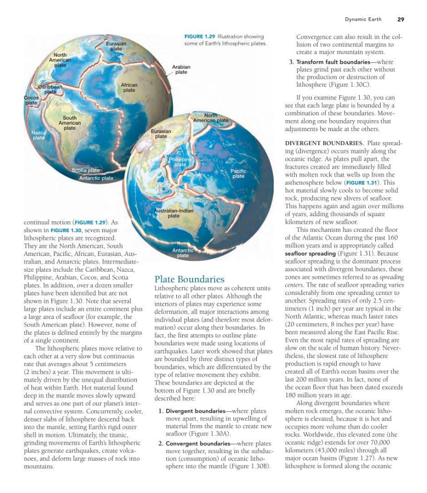
FIGURE 1.29 Illustration showing
some of Earth’s lithospheric plates.
continual motion (FIGURE 1.29). As
shown in FIGURE 1.30, seven major
lithospheric plates are recognized.
They are the North American, South
American, Pacific, African, Eurasian, Australian, and Antarctic plates. Intermediatesize plates include the Caribbean, Nazca,
Philippine, Arabian, Cocos, and Scotia
plates. In addition, over a dozen smaller
plates have been identified but are not
shown in Figure 1.30. Note that several
large plates include an entire continent plus
a large area of seafloor (for example, the
South American plate). However, none of
the plates is defined entirely by the margins
of a single continent.
The lithospheric plates move relative to
each other at a very slow but continuous
rate that averages about 5 centimeters
(2 inches) a year. This movement is ultimately driven by the unequal distribution
of heat within Earth. Hot material found
deep in the mantle moves slowly upward
and serves as one part of our planet’ s internal convective system. Concurrently, cooler,
denser slabs of lithosphere descend back
into the mantle, setting Earth’ s rigid outer
shell in motion. Ultimately, the titanic,
grinding movements of Earth’ s lithospheric
plates generate earthquakes, create volcanoes, and deform large masses of rock into
mountains.
Plate Boundaries
Lithospheric plates move as coherent units
relative to all other plates. Although the
interiors of plates may experience some
deformation, all major interactions among
individual plates (and therefore most deformation) occur along their boundaries. In
fact, the first attempts to outline plate
boundaries were made using locations of
earthquakes. Later work showed that plates
are bounded by three distinct types of
boundaries, which are differentiated by the
type of relative movement they exhibit.
These boundaries are depicted at the
bottom of Figure 1.30 and are briefly
described here:
1. Divergent boundaries—where plates
move apart, resulting in upwelling of
material from the mantle to create new
seafloor (Figure 1.30A).
2. Convergent boundaries—where plates
move together, resulting in the subduction (consumption) of oceanic lithosphere into the mantle (Figure 1.30B).
Convergence can also result in the collision of two continental margins to
create a major mountain system.
3. Transform fault boundaries—where
plates grind past each other without
the production or destruction of
lithosphere (Figure 1.30C).
If you examine Figure 1.30, you can
see that each large plate is bounded by a
combination of these boundaries. Movement along one boundary requires that
adjustments be made at the others.
DIVERGENT BOUNDARIES. Plate spreading (divergence) occurs mainly along the
oceanic ridge. As plates pull apart, the
fractures created are immediately filled
with molten rock that wells up from the
asthenosphere below (FIGURE 1.31). This
hot material slowly cools to become solid
rock, producing new slivers of seafloor.
This happens again and again over millions
of years, adding thousands of square
kilometers of new seafloor.
This mechanism has created the floor
of the Atlantic Ocean during the past 160
million years and is appropriately called
seafloor spreading (Figure 1.31). Because
seafloor spreading is the dominant process
associated with divergent boundaries, these
zones are sometimes referred to as spreading
centers. The rate of seafloor spreading varies
considerably from one spreading center to
another. Spreading rates of only 2.5 centimeters (1 inch) per year are typical in the
North Atlantic, whereas much faster rates
(20 centimeters, 8 inches per year) have
been measured along the East Pacific Rise.
Even the most rapid rates of spreading are
slow on the scale of human history. Nevertheless, the slowest rate of lithosphere
production is rapid enough to have
created all of Earth’ s ocean basins over the
last 200 million years. In fact, none of
the ocean floor that has been dated exceeds
180 million years in age.
Along divergent boundaries where
molten rock emerges, the oceanic lithosphere is elevated, because it is hot and
occupies more volume than do cooler
rocks. Worldwide, this elevated zone (the
oceanic ridge) extends for over 70,000
kilometers (43,000 miles) through all
major ocean basins (Figure 1.27). As new
lithosphere is formed along the oceanic
Dynamic Earth
North
American
plate
South
American
plate
African
plate
Eurasian
plate
Eurasian
plate
Australian-Indian
plate
Pacific
plate
Philippine
plate
Antarctic plate
North
American plate
Nazca
plate
Antarctic
plate
Arabian
plate
Cocos
plate
Caribbean
plate
Scotia plate
FIGURE 1.29 Illustration showing
some of Earth’s lithospheric plates.
continual motion (FIGURE 1.29). As
shown in FIGURE 1.30, seven major
lithospheric plates are recognized.
They are the North American, South
American, Pacific, African, Eurasian, Australian, and Antarctic plates. Intermediatesize plates include the Caribbean, Nazca,
Philippine, Arabian, Cocos, and Scotia
plates. In addition, over a dozen smaller
plates have been identified but are not
shown in Figure 1.30. Note that several
large plates include an entire continent plus
a large area of seafloor (for example, the
South American plate). However, none of
the plates is defined entirely by the margins
of a single continent.
The lithospheric plates move relative to
each other at a very slow but continuous
rate that averages about 5 centimeters
(2 inches) a year. This movement is ultimately driven by the unequal distribution
of heat within Earth. Hot material found
deep in the mantle moves slowly upward
and serves as one part of our planet’ s internal convective system. Concurrently, cooler,
denser slabs of lithosphere descend back
into the mantle, setting Earth’ s rigid outer
shell in motion. Ultimately, the titanic,
grinding movements of Earth’ s lithospheric
plates generate earthquakes, create volcanoes, and deform large masses of rock into
mountains.
Plate Boundaries
Lithospheric plates move as coherent units
relative to all other plates. Although the
interiors of plates may experience some
deformation, all major interactions among
individual plates (and therefore most deformation) occur along their boundaries. In
fact, the first attempts to outline plate
boundaries were made using locations of
earthquakes. Later work showed that plates
are bounded by three distinct types of
boundaries, which are differentiated by the
type of relative movement they exhibit.
These boundaries are depicted at the
bottom of Figure 1.30 and are briefly
described here:
1. Divergent boundaries—where plates
move apart, resulting in upwelling of
material from the mantle to create new
seafloor (Figure 1.30A).
2. Convergent boundaries—where plates
move together, resulting in the subduction (consumption) of oceanic lithosphere into the mantle (Figure 1.30B).
Convergence can also result in the collision of two continental margins to
create a major mountain system.
3. Transform fault boundaries—where
plates grind past each other without
the production or destruction of
lithosphere (Figure 1.30C).
If you examine Figure 1.30, you can
see that each large plate is bounded by a
combination of these boundaries. Movement along one boundary requires that
adjustments be made at the others.
DIVERGENT BOUNDARIES. Plate spreading (divergence) occurs mainly along the
oceanic ridge. As plates pull apart, the
fractures created are immediately filled
with molten rock that wells up from the
asthenosphere below (FIGURE 1.31). This
hot material slowly cools to become solid
rock, producing new slivers of seafloor.
This happens again and again over millions
of years, adding thousands of square
kilometers of new seafloor.
This mechanism has created the floor
of the Atlantic Ocean during the past 160
million years and is appropriately called
seafloor spreading (Figure 1.31). Because
seafloor spreading is the dominant process
associated with divergent boundaries, these
zones are sometimes referred to as spreading
centers. The rate of seafloor spreading varies
considerably from one spreading center to
another. Spreading rates of only 2.5 centimeters (1 inch) per year are typical in the
North Atlantic, whereas much faster rates
(20 centimeters, 8 inches per year) have
been measured along the East Pacific Rise.
Even the most rapid rates of spreading are
slow on the scale of human history. Nevertheless, the slowest rate of lithosphere
production is rapid enough to have
created all of Earth’ s ocean basins over the
last 200 million years. In fact, none of
the ocean floor that has been dated exceeds
180 million years in age.
Along divergent boundaries where
molten rock emerges, the oceanic lithosphere is elevated, because it is hot and
occupies more volume than do cooler
rocks. Worldwide, this elevated zone (the
oceanic ridge) extends for over 70,000
kilometers (43,000 miles) through all
major ocean basins (Figure 1.27). As new
lithosphere is formed along the oceanic