

CHAPTER 19 Earth’s Evolution through Geologic Time
472
North
America
Siberia
Northern
Europe
Australia
South
America
Africa
India
Antarctica
R O D I N I A
E q u
a t o r
South pole
SUPERCONTINENTS AND CLIMATE. As continents move, the patterns of ocean currents
and global winds change, which influences the global distribution of temperature and precipitation. One example of how a supercontinent’ s dispersal influenced climate is the formation of the Antarctic ice sheet. Although eastern Antarctica remained over the South
Pole for more than 100 million years, it was not glaciated until about 25 million years ago.
Prior to this period of glaciation, South America was connected to the Antarctic Peninsula.
This arrangement of landmasses helped maintain a circulation pattern in which warm
ocean currents reached the coast of Antarctica as shown in FIGURE 19.16A. This is similar to
the way in which the modern Gulf Stream keeps Iceland
mostly ice free, despite its name. However, as South
America separated from Antarctica, it moved
northward, permitting ocean circulation to
flow from west to east around the entire continent of Antarctica (FIGURE 19.16B). This
cold current, called the West Wind Drift,
effectively isolated the entire Antarctic
coast from the warm, poleward-directed
currents in the southern oceans. As a
result, most of the Antarctic landmass
became covered with glacial ice.
Local and regional climates have also
been impacted by large mountain systems
created by the collision of large cratons.
Because of their high elevations, mountains
exhibit markedly lower average temperatures than surrounding lowlands. In
addition, when air rises over these lofty
structures, lifting “squeezes” moisture from
the air, leaving the region downwind
relatively dry. A modern analogy is the wet,
G
r e n v i l l e
A p p a l a c h i a n
Wyoming
S la v e
W
o
p
m
a
y
Baffin
Superior
Yavapai
M a z a tz a l- P e c o s
H e a r n e - R a e
C a le d o n id e s
Co rdi lle ra
M
o j a v e
Trans
Hudso n
o r o g en
Age (Ga)
<1.0
1.0–1.2
1.6–1.7
1.7–1.8
1.8–2.0
2.5–3.0
>3.5
Thelon
FIGURE 19.13 Map showing
the major geological provinces
of North America and their ages
in billions of years (Ga). It
appears that North America was
assembled from crustal blocks
that were joined by processes
very similar to modern plate
tectonics. These ancient
collisions produced
mountainous belts that include
remnant volcanic island arcs
trapped by the colliding
continental fragments.
South pole
South pole
North
America
Siberia
Northern
Europe
Australia
South
America
Africa
India
Antarctica
G O
N D W
A N A
A. Continent of Gondwana
B. Continents not a part of Gondwana
E q u a to r
Equator
FIGURE 19.15 Reconstruction of Earth as it may
have appeared in late Precambrian time. The
southern continents were joined into a single
landmass called Gondwana. Other landmasses
that were not part of Gondwana include North
America, northwestern Europe, and northern Asia.
(After P. Hoffman, J. Rogers, and others)
D I D Y O U K N O W ?
You are probably most familiar with
animals that have backbones
(vertebrates), such as humans, dogs,
fish, and frogs. However, 98 percent of
the major animal groups are
invertebrates. Examples of the latter
group include insects, corals, clams,
and starfish.
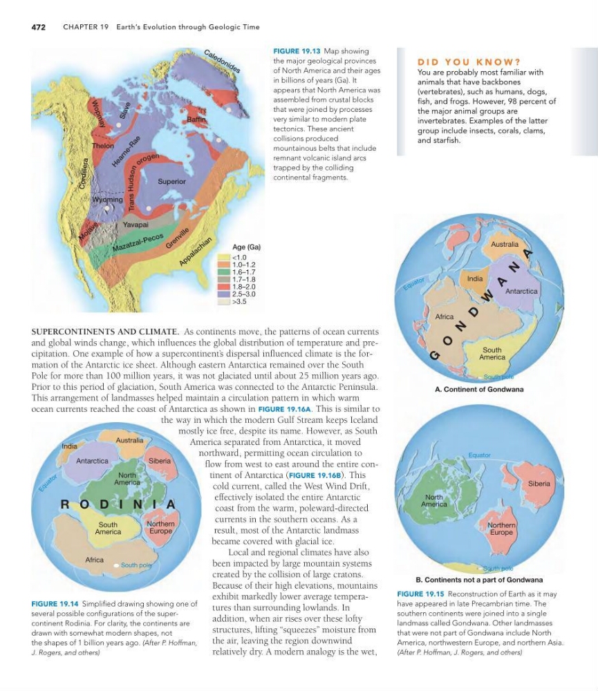
FIGURE 19.14 Simplified drawing showing one of
several possible configurations of the supercontinent Rodinia. For clarity, the continents are
drawn with somewhat modern shapes, not
the shapes of 1 billion years ago. (After P. Hoffman,
J. Rogers, and others)
472
North
America
Siberia
Northern
Europe
Australia
South
America
Africa
India
Antarctica
R O D I N I A
E q u
a t o r
South pole
SUPERCONTINENTS AND CLIMATE. As continents move, the patterns of ocean currents
and global winds change, which influences the global distribution of temperature and precipitation. One example of how a supercontinent’ s dispersal influenced climate is the formation of the Antarctic ice sheet. Although eastern Antarctica remained over the South
Pole for more than 100 million years, it was not glaciated until about 25 million years ago.
Prior to this period of glaciation, South America was connected to the Antarctic Peninsula.
This arrangement of landmasses helped maintain a circulation pattern in which warm
ocean currents reached the coast of Antarctica as shown in FIGURE 19.16A. This is similar to
the way in which the modern Gulf Stream keeps Iceland
mostly ice free, despite its name. However, as South
America separated from Antarctica, it moved
northward, permitting ocean circulation to
flow from west to east around the entire continent of Antarctica (FIGURE 19.16B). This
cold current, called the West Wind Drift,
effectively isolated the entire Antarctic
coast from the warm, poleward-directed
currents in the southern oceans. As a
result, most of the Antarctic landmass
became covered with glacial ice.
Local and regional climates have also
been impacted by large mountain systems
created by the collision of large cratons.
Because of their high elevations, mountains
exhibit markedly lower average temperatures than surrounding lowlands. In
addition, when air rises over these lofty
structures, lifting “squeezes” moisture from
the air, leaving the region downwind
relatively dry. A modern analogy is the wet,
G
r e n v i l l e
A p p a l a c h i a n
Wyoming
S la v e
W
o
p
m
a
y
Baffin
Superior
Yavapai
M a z a tz a l- P e c o s
H e a r n e - R a e
C a le d o n id e s
Co rdi lle ra
M
o j a v e
Trans
Hudso n
o r o g en
Age (Ga)
<1.0
1.0–1.2
1.6–1.7
1.7–1.8
1.8–2.0
2.5–3.0
>3.5
Thelon
FIGURE 19.13 Map showing
the major geological provinces
of North America and their ages
in billions of years (Ga). It
appears that North America was
assembled from crustal blocks
that were joined by processes
very similar to modern plate
tectonics. These ancient
collisions produced
mountainous belts that include
remnant volcanic island arcs
trapped by the colliding
continental fragments.
South pole
South pole
North
America
Siberia
Northern
Europe
Australia
South
America
Africa
India
Antarctica
G O
N D W
A N A
A. Continent of Gondwana
B. Continents not a part of Gondwana
E q u a to r
Equator
FIGURE 19.15 Reconstruction of Earth as it may
have appeared in late Precambrian time. The
southern continents were joined into a single
landmass called Gondwana. Other landmasses
that were not part of Gondwana include North
America, northwestern Europe, and northern Asia.
(After P. Hoffman, J. Rogers, and others)
D I D Y O U K N O W ?
You are probably most familiar with
animals that have backbones
(vertebrates), such as humans, dogs,
fish, and frogs. However, 98 percent of
the major animal groups are
invertebrates. Examples of the latter
group include insects, corals, clams,
and starfish.
FIGURE 19.14 Simplified drawing showing one of
several possible configurations of the supercontinent Rodinia. For clarity, the continents are
drawn with somewhat modern shapes, not
the shapes of 1 billion years ago. (After P. Hoffman,
J. Rogers, and others)