

CHAPTER 17 Crustal Deformation and Mountain Building
432
A.
B.
Grand Teton Range
Jackson Hole
C.
D I D Y O U K N O W ?
The greatest accumulations of snow
generally occur in mountainous
regions. In the United States, the
record for a single season was in
Mount Baker ski area north of Seattle,
Washington, where 1140 inches
(95 feet!) of snow fell during the winter
of 1998–99.
FIGURE 17.26 This drawing illustrates how
wooden blocks of different thicknesses float in
water. In a similar manner, thick sections of crustal
material float higher than thinner crustal slabs.
Basin and Range Province
Located between the Sierra Nevada and Rocky Mountains is one of Earth’ s largest regions of
fault-block mountains—the Basin and Range Province (see Figure 17.12). This region
extends in a roughly north-south direction for nearly 3000 kilometers (2000 miles) and
encompasses all of Nevada and portions of the surrounding states, as well as parts of southern Canada and western Mexico. In this region, the brittle upper crust has literally been
broken into hundreds of fault blocks. Tilting of these faulted structures called half-grabens,
gave rise to nearly parallel mountain ranges, averaging about 80 kilometers in length, which
rise above adjacent sediment-filled basins (see Figure 17.12).
Extension in the Basin and Range Province began about 20 million years ago and
appears to have “stretched” the crust as much as twice its original width. High heat flow in
the region and several episodes of volcanism provide strong evidence that mantle upwelling
caused doming of the crust, which in turn contributed to extension in the region.
C O N C E P T C H E C K 1 7 . 7
Compare the processes that generate fault-block mountains to those associated
with most other major mountain belts.
Vertical Movements of the Crust
Gradual up-and-down motions of the continental crust occur at many locations around the
globe. Unfortunately, the reasons for these changes are not easily determined.
Isostasy
During the 1840s, researchers discovered that Earth’ s low-density crust floats on top of the
high-density, deformable rocks of the mantle. The concept of a floating crust in gravitational
balance is called isostasy. One way to explore this concept is to envision a series of wooden
blocks of different heights floating in water, as shown in FIGURE 17.26. Note that the thicker
wooden blocks float higher than the thinner blocks. Similarly, compressional mountains
stand high above the surrounding terrain because crustal thickening creates buoyant crustal
“roots” that extend deep into the supporting material below. Thus, lofty mountains behave
much like the thicker wooden blocks shown in Figure 17.26.
ISOSTATIC ADJUSTMENT. Visualize what would happen if another small block of wood
were placed atop one of the blocks in Figure 17.26. The combined block would sink until
it reached a new isostatic (gravitational) balance. At this point, the top of the combined
block would be higher than
1
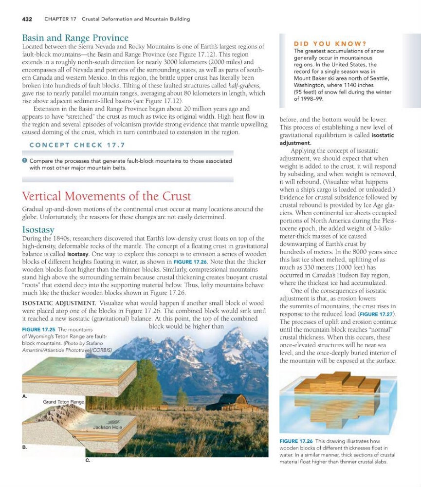
FIGURE 17.25 The mountains
of Wyoming’s Teton Range are faultblock mountains. (Photo by Stafano
Amantini/Atlantide Phototravel/CORBIS)
before, and the bottom would be lower.
This process of establishing a new level of
gravitational equilibrium is called isostatic
adjustment.
Applying the concept of isostatic
adjustment, we should expect that when
weight is added to the crust, it will respond
by subsiding, and when weight is removed,
it will rebound. (Visualize what happens
when a ship’ s cargo is loaded or unloaded.)
Evidence for crustal subsidence followed by
crustal rebound is provided by Ice Age glaciers. When continental ice sheets occupied
portions of North America during the Pleistocene epoch, the added weight of 3-kilometer-thick masses of ice caused
downwarping of Earth’ s crust by
hundreds of meters. In the 8000 years since
this last ice sheet melted, uplifting of as
much as 330 meters (1000 feet) has
occurred in Canada’ s Hudson Bay region,
where the thickest ice had accumulated.
One of the consequences of isostatic
adjustment is that, as erosion lowers
the summits of mountains, the crust rises in
response to the reduced load (FIGURE 17.27).
The processes of uplift and erosion continue
until the mountain block reaches “normal”
crustal thickness. When this occurs, these
once-elevated structures will be near sea
level, and the once-deeply buried interior of
the mountain will be exposed at the surface.
432
A.
B.
Grand Teton Range
Jackson Hole
C.
D I D Y O U K N O W ?
The greatest accumulations of snow
generally occur in mountainous
regions. In the United States, the
record for a single season was in
Mount Baker ski area north of Seattle,
Washington, where 1140 inches
(95 feet!) of snow fell during the winter
of 1998–99.
FIGURE 17.26 This drawing illustrates how
wooden blocks of different thicknesses float in
water. In a similar manner, thick sections of crustal
material float higher than thinner crustal slabs.
Basin and Range Province
Located between the Sierra Nevada and Rocky Mountains is one of Earth’ s largest regions of
fault-block mountains—the Basin and Range Province (see Figure 17.12). This region
extends in a roughly north-south direction for nearly 3000 kilometers (2000 miles) and
encompasses all of Nevada and portions of the surrounding states, as well as parts of southern Canada and western Mexico. In this region, the brittle upper crust has literally been
broken into hundreds of fault blocks. Tilting of these faulted structures called half-grabens,
gave rise to nearly parallel mountain ranges, averaging about 80 kilometers in length, which
rise above adjacent sediment-filled basins (see Figure 17.12).
Extension in the Basin and Range Province began about 20 million years ago and
appears to have “stretched” the crust as much as twice its original width. High heat flow in
the region and several episodes of volcanism provide strong evidence that mantle upwelling
caused doming of the crust, which in turn contributed to extension in the region.
C O N C E P T C H E C K 1 7 . 7
Compare the processes that generate fault-block mountains to those associated
with most other major mountain belts.
Vertical Movements of the Crust
Gradual up-and-down motions of the continental crust occur at many locations around the
globe. Unfortunately, the reasons for these changes are not easily determined.
Isostasy
During the 1840s, researchers discovered that Earth’ s low-density crust floats on top of the
high-density, deformable rocks of the mantle. The concept of a floating crust in gravitational
balance is called isostasy. One way to explore this concept is to envision a series of wooden
blocks of different heights floating in water, as shown in FIGURE 17.26. Note that the thicker
wooden blocks float higher than the thinner blocks. Similarly, compressional mountains
stand high above the surrounding terrain because crustal thickening creates buoyant crustal
“roots” that extend deep into the supporting material below. Thus, lofty mountains behave
much like the thicker wooden blocks shown in Figure 17.26.
ISOSTATIC ADJUSTMENT. Visualize what would happen if another small block of wood
were placed atop one of the blocks in Figure 17.26. The combined block would sink until
it reached a new isostatic (gravitational) balance. At this point, the top of the combined
block would be higher than
1
FIGURE 17.25 The mountains
of Wyoming’s Teton Range are faultblock mountains. (Photo by Stafano
Amantini/Atlantide Phototravel/CORBIS)
before, and the bottom would be lower.
This process of establishing a new level of
gravitational equilibrium is called isostatic
adjustment.
Applying the concept of isostatic
adjustment, we should expect that when
weight is added to the crust, it will respond
by subsiding, and when weight is removed,
it will rebound. (Visualize what happens
when a ship’ s cargo is loaded or unloaded.)
Evidence for crustal subsidence followed by
crustal rebound is provided by Ice Age glaciers. When continental ice sheets occupied
portions of North America during the Pleistocene epoch, the added weight of 3-kilometer-thick masses of ice caused
downwarping of Earth’ s crust by
hundreds of meters. In the 8000 years since
this last ice sheet melted, uplifting of as
much as 330 meters (1000 feet) has
occurred in Canada’ s Hudson Bay region,
where the thickest ice had accumulated.
One of the consequences of isostatic
adjustment is that, as erosion lowers
the summits of mountains, the crust rises in
response to the reduced load (FIGURE 17.27).
The processes of uplift and erosion continue
until the mountain block reaches “normal”
crustal thickness. When this occurs, these
once-elevated structures will be near sea
level, and the once-deeply buried interior of
the mountain will be exposed at the surface.