

431
Fault-Block Mountains
D I D Y O U K N O W ?
During the assembly of Pangaea, the
landmasses of Europe and Siberia
collided to produce the Ural Mountains.
Long before the discovery of plate
tectonics, this extensively eroded
mountain chain was regarded as the
boundary between Europe and Asia.
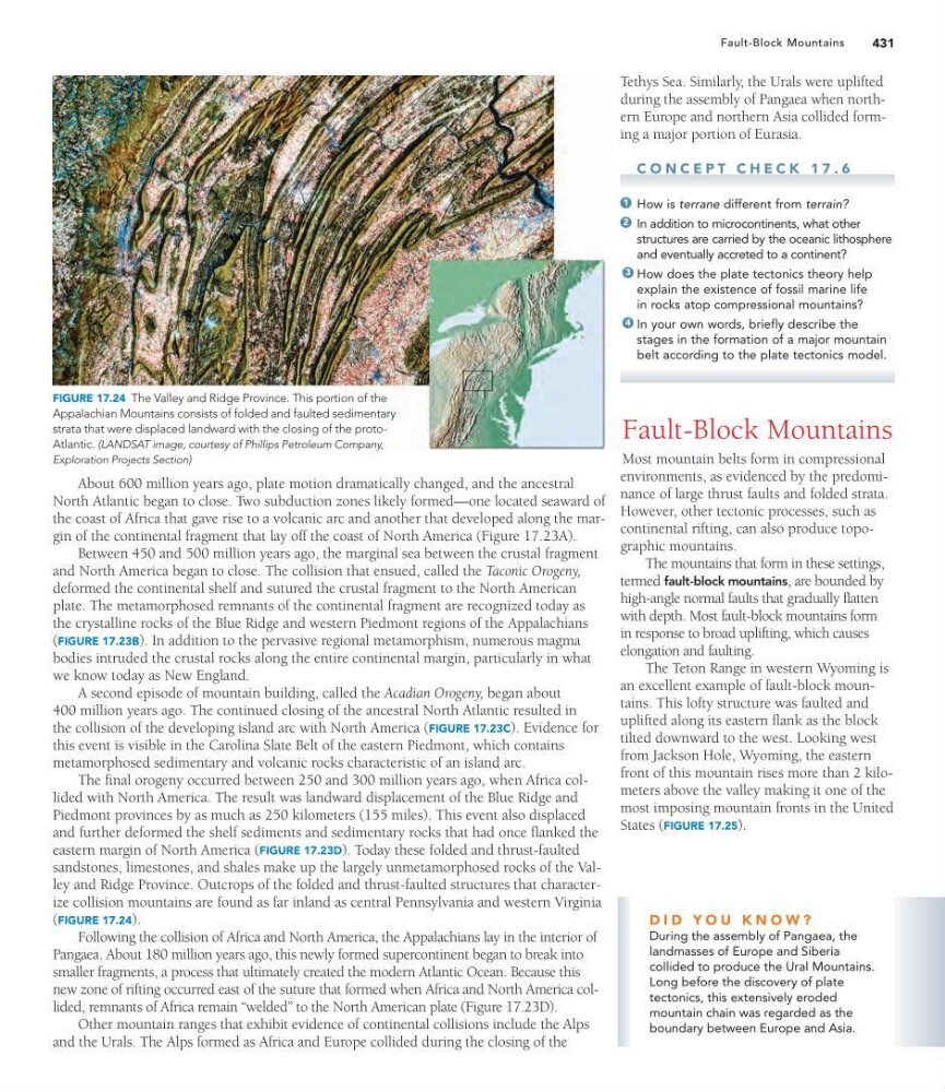
FIGURE 17.24 The Valley and Ridge Province. This portion of the
Appalachian Mountains consists of folded and faulted sedimentary
strata that were displaced landward with the closing of the protoAtlantic. (LANDSAT image, courtesy of Phillips Petroleum Company,
Exploration Projects Section)
Tethys Sea. Similarly, the Urals were uplifted
during the assembly of Pangaea when northern Europe and northern Asia collided forming a major portion of Eurasia.
C O N C E P T C H E C K 1 7 . 6
How is terrane different from terrain?
In addition to microcontinents, what other
structures are carried by the oceanic lithosphere
and eventually accreted to a continent?
How does the plate tectonics theory help
explain the existence of fossil marine life
in rocks atop compressional mountains?
In your own words, briefly describe the
stages in the formation of a major mountain
belt according to the plate tectonics model.
Fault-Block Mountains
Most mountain belts form in compressional
environments, as evidenced by the predominance of large thrust faults and folded strata.
However, other tectonic processes, such as
continental rifting, can also produce topographic mountains.
The mountains that form in these settings,
termed fault-block mountains, are bounded by
high-angle normal faults that gradually flatten
with depth. Most fault-block mountains form
in response to broad uplifting, which causes
elongation and faulting.
The Teton Range in western Wyoming is
an excellent example of fault-block mountains. This lofty structure was faulted and
uplifted along its eastern flank as the block
tilted downward to the west. Looking west
from Jackson Hole, Wyoming, the eastern
front of this mountain rises more than 2 kilometers above the valley making it one of the
most imposing mountain fronts in the United
States (FIGURE 17.25).
4
3
2
1
About 600 million years ago, plate motion dramatically changed, and the ancestral
North Atlantic began to close. Two subduction zones likely formed—one located seaward of
the coast of Africa that gave rise to a volcanic arc and another that developed along the margin of the continental fragment that lay off the coast of North America (Figure 17.23A).
Between 450 and 500 million years ago, the marginal sea between the crustal fragment
and North America began to close. The collision that ensued, called the Taconic Orogeny,
deformed the continental shelf and sutured the crustal fragment to the North American
plate. The metamorphosed remnants of the continental fragment are recognized today as
the crystalline rocks of the Blue Ridge and western Piedmont regions of the Appalachians
(FIGURE 17.23B). In addition to the pervasive regional metamorphism, numerous magma
bodies intruded the crustal rocks along the entire continental margin, particularly in what
we know today as New England.
A second episode of mountain building, called the Acadian Orogeny, began about
400 million years ago. The continued closing of the ancestral North Atlantic resulted in
the collision of the developing island arc with North America (FIGURE 17.23C). Evidence for
this event is visible in the Carolina Slate Belt of the eastern Piedmont, which contains
metamorphosed sedimentary and volcanic rocks characteristic of an island arc.
The final orogeny occurred between 250 and 300 million years ago, when Africa collided with North America. The result was landward displacement of the Blue Ridge and
Piedmont provinces by as much as 250 kilometers (155 miles). This event also displaced
and further deformed the shelf sediments and sedimentary rocks that had once flanked the
eastern margin of North America (FIGURE 17.23D). Today these folded and thrust-faulted
sandstones, limestones, and shales make up the largely unmetamorphosed rocks of the Valley and Ridge Province. Outcrops of the folded and thrust-faulted structures that characterize collision mountains are found as far inland as central Pennsylvania and western Virginia
(FIGURE 17.24).
Following the collision of Africa and North America, the Appalachians lay in the interior of
Pangaea. About 180 million years ago, this newly formed supercontinent began to break into
smaller fragments, a process that ultimately created the modern Atlantic Ocean. Because this
new zone of rifting occurred east of the suture that formed when Africa and North America collided, remnants of Africa remain “welded” to the North American plate (Figure 17.23D).
Other mountain ranges that exhibit evidence of continental collisions include the Alps
and the Urals. The Alps formed as Africa and Europe collided during the closing of the
Fault-Block Mountains
D I D Y O U K N O W ?
During the assembly of Pangaea, the
landmasses of Europe and Siberia
collided to produce the Ural Mountains.
Long before the discovery of plate
tectonics, this extensively eroded
mountain chain was regarded as the
boundary between Europe and Asia.
FIGURE 17.24 The Valley and Ridge Province. This portion of the
Appalachian Mountains consists of folded and faulted sedimentary
strata that were displaced landward with the closing of the protoAtlantic. (LANDSAT image, courtesy of Phillips Petroleum Company,
Exploration Projects Section)
Tethys Sea. Similarly, the Urals were uplifted
during the assembly of Pangaea when northern Europe and northern Asia collided forming a major portion of Eurasia.
C O N C E P T C H E C K 1 7 . 6
How is terrane different from terrain?
In addition to microcontinents, what other
structures are carried by the oceanic lithosphere
and eventually accreted to a continent?
How does the plate tectonics theory help
explain the existence of fossil marine life
in rocks atop compressional mountains?
In your own words, briefly describe the
stages in the formation of a major mountain
belt according to the plate tectonics model.
Fault-Block Mountains
Most mountain belts form in compressional
environments, as evidenced by the predominance of large thrust faults and folded strata.
However, other tectonic processes, such as
continental rifting, can also produce topographic mountains.
The mountains that form in these settings,
termed fault-block mountains, are bounded by
high-angle normal faults that gradually flatten
with depth. Most fault-block mountains form
in response to broad uplifting, which causes
elongation and faulting.
The Teton Range in western Wyoming is
an excellent example of fault-block mountains. This lofty structure was faulted and
uplifted along its eastern flank as the block
tilted downward to the west. Looking west
from Jackson Hole, Wyoming, the eastern
front of this mountain rises more than 2 kilometers above the valley making it one of the
most imposing mountain fronts in the United
States (FIGURE 17.25).
4
3
2
1
About 600 million years ago, plate motion dramatically changed, and the ancestral
North Atlantic began to close. Two subduction zones likely formed—one located seaward of
the coast of Africa that gave rise to a volcanic arc and another that developed along the margin of the continental fragment that lay off the coast of North America (Figure 17.23A).
Between 450 and 500 million years ago, the marginal sea between the crustal fragment
and North America began to close. The collision that ensued, called the Taconic Orogeny,
deformed the continental shelf and sutured the crustal fragment to the North American
plate. The metamorphosed remnants of the continental fragment are recognized today as
the crystalline rocks of the Blue Ridge and western Piedmont regions of the Appalachians
(FIGURE 17.23B). In addition to the pervasive regional metamorphism, numerous magma
bodies intruded the crustal rocks along the entire continental margin, particularly in what
we know today as New England.
A second episode of mountain building, called the Acadian Orogeny, began about
400 million years ago. The continued closing of the ancestral North Atlantic resulted in
the collision of the developing island arc with North America (FIGURE 17.23C). Evidence for
this event is visible in the Carolina Slate Belt of the eastern Piedmont, which contains
metamorphosed sedimentary and volcanic rocks characteristic of an island arc.
The final orogeny occurred between 250 and 300 million years ago, when Africa collided with North America. The result was landward displacement of the Blue Ridge and
Piedmont provinces by as much as 250 kilometers (155 miles). This event also displaced
and further deformed the shelf sediments and sedimentary rocks that had once flanked the
eastern margin of North America (FIGURE 17.23D). Today these folded and thrust-faulted
sandstones, limestones, and shales make up the largely unmetamorphosed rocks of the Valley and Ridge Province. Outcrops of the folded and thrust-faulted structures that characterize collision mountains are found as far inland as central Pennsylvania and western Virginia
(FIGURE 17.24).
Following the collision of Africa and North America, the Appalachians lay in the interior of
Pangaea. About 180 million years ago, this newly formed supercontinent began to break into
smaller fragments, a process that ultimately created the modern Atlantic Ocean. Because this
new zone of rifting occurred east of the suture that formed when Africa and North America collided, remnants of Africa remain “welded” to the North American plate (Figure 17.23D).
Other mountain ranges that exhibit evidence of continental collisions include the Alps
and the Urals. The Alps formed as Africa and Europe collided during the closing of the