

Wrangellia
Yukon Tanana
Cache Creek
Oceanic
terranes
U N I T E D S T A T E S
ALASKA
C A N A D A
M E X I C O
A R C T I C
O C E A N
P A C I F I C
O C E A N
S t i k i n i a
W r a n g e l l i a
F
r
a n c i s c a n
429
Collisional Mountain Belts
FIGURE 17.21 Diagrams
illustrating the collision of
India with the Eurasian
plate, producing the
spectacular Himalayas.
A.
Asthenosphere
B.
Continental
crust
Developing
accretionary
wedge
Continental
volcanic arc
Partial melting of
deeply buried
sediments
Asthenosphere
Thick sequence
of shallow marine
sedimentary rocks
Suture Suture Suture
India
Himalayas
Asia
Ophiolite
(fragment of
oceanic crust)
Continental
crust
Continental
crust
Continental
crust
Oceanic
crust
Subducting oce an ic li t h o s p h e r e
Continental collision results in
deformation of crustal rocks by
folding and thrust faulting
T
I
M
E
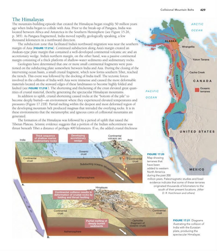
FIGURE 17.20
Map showing
terranes that
have been
added to western
North America
during the past 200
million years. Paleomagnetic studies and fossil
evidence indicate that some of these terranes
originated thousands of kilometers to the
south of their present locations. (After
D. R. Hutchinson and others)
The Himalayas
The mountain-building episode that created the Himalayas began roughly 50 million years
ago when India began to collide with Asia. Prior to the break-up of Pangaea, India was
located between Africa and Antarctica in the Southern Hemisphere (see Figure 15.26,
p. 385). As Pangaea fragmented, India moved rapidly, geologically speaking, a few
thousand kilometers in a northward direction.
The subduction zone that facilitated India’ s northward migration was near the southern
margin of Asia (FIGURE 17.21A). Continued subduction along Asia’ s margin created an
Andean-type plate margin that contained a well-developed continental volcanic arc and an
accretionary wedge. India’ s northern margin, on the other hand, was a passive continental
margin consisting of a thick platform of shallow-water sediments and sedimentary rocks.
Geologists have determined that one or more small continental fragments were positioned on the subducting plate somewhere between India and Asia. During the closing of the
intervening ocean basin, a small crustal fragment, which now forms southern Tibet, reached
the trench. This event was followed by the docking of India itself. The tectonic forces
involved in the collision of India with Asia were immense and caused the more deformable
materials located on the seaward edges of these landmasses to become highly folded and
faulted (see FIGURE 17.21B ). The shortening and thickening of the crust elevated great quantities of crustal material, thereby generating the spectacular Himalayan mountains.
In addition to uplift, crustal shortening caused rocks at the “bottom of the pile” to
become deeply buried—an environment where they experienced elevated temperatures and
pressures (Figure 17.21B). Partial melting within the deepest and most deformed region of
the developing mountain belt produced magmas that intruded the overlying rocks. It is in
these environments that the metamorphic and igneous cores of collisional mountains are
generated.
The formation of the Himalayas was followed by a period of uplift that raised the
Tibetan Plateau. Seismic evidence suggests that a portion of the Indian subcontinent was
thrust beneath Tibet a distance of perhaps 400 kilometers. If so, the added crustal thickness
Yukon Tanana
Cache Creek
Oceanic
terranes
U N I T E D S T A T E S
ALASKA
C A N A D A
M E X I C O
A R C T I C
O C E A N
P A C I F I C
O C E A N
S t i k i n i a
W r a n g e l l i a
F
r
a n c i s c a n
429
Collisional Mountain Belts
FIGURE 17.21 Diagrams
illustrating the collision of
India with the Eurasian
plate, producing the
spectacular Himalayas.
A.
Asthenosphere
B.
Continental
crust
Developing
accretionary
wedge
Continental
volcanic arc
Partial melting of
deeply buried
sediments
Asthenosphere
Thick sequence
of shallow marine
sedimentary rocks
Suture Suture Suture
India
Himalayas
Asia
Ophiolite
(fragment of
oceanic crust)
Continental
crust
Continental
crust
Continental
crust
Oceanic
crust
Subducting oce an ic li t h o s p h e r e
Continental collision results in
deformation of crustal rocks by
folding and thrust faulting
T
I
M
E
FIGURE 17.20
Map showing
terranes that
have been
added to western
North America
during the past 200
million years. Paleomagnetic studies and fossil
evidence indicate that some of these terranes
originated thousands of kilometers to the
south of their present locations. (After
D. R. Hutchinson and others)
The Himalayas
The mountain-building episode that created the Himalayas began roughly 50 million years
ago when India began to collide with Asia. Prior to the break-up of Pangaea, India was
located between Africa and Antarctica in the Southern Hemisphere (see Figure 15.26,
p. 385). As Pangaea fragmented, India moved rapidly, geologically speaking, a few
thousand kilometers in a northward direction.
The subduction zone that facilitated India’ s northward migration was near the southern
margin of Asia (FIGURE 17.21A). Continued subduction along Asia’ s margin created an
Andean-type plate margin that contained a well-developed continental volcanic arc and an
accretionary wedge. India’ s northern margin, on the other hand, was a passive continental
margin consisting of a thick platform of shallow-water sediments and sedimentary rocks.
Geologists have determined that one or more small continental fragments were positioned on the subducting plate somewhere between India and Asia. During the closing of the
intervening ocean basin, a small crustal fragment, which now forms southern Tibet, reached
the trench. This event was followed by the docking of India itself. The tectonic forces
involved in the collision of India with Asia were immense and caused the more deformable
materials located on the seaward edges of these landmasses to become highly folded and
faulted (see FIGURE 17.21B ). The shortening and thickening of the crust elevated great quantities of crustal material, thereby generating the spectacular Himalayan mountains.
In addition to uplift, crustal shortening caused rocks at the “bottom of the pile” to
become deeply buried—an environment where they experienced elevated temperatures and
pressures (Figure 17.21B). Partial melting within the deepest and most deformed region of
the developing mountain belt produced magmas that intruded the overlying rocks. It is in
these environments that the metamorphic and igneous cores of collisional mountains are
generated.
The formation of the Himalayas was followed by a period of uplift that raised the
Tibetan Plateau. Seismic evidence suggests that a portion of the Indian subcontinent was
thrust beneath Tibet a distance of perhaps 400 kilometers. If so, the added crustal thickness